CNFE AAP - Interim Sustainability Appraisal Report
3. Cambridge Northern Fringe East Area Action Plan
3.1 The Existing Site: Constraints and Opportunities
The CNFE AAP boundary is shown on Figure 3.1. The area contains a number of constraints and opportunities which have a strong influence on the alternative schemes possible for this area. The constraints and opportunities which have been considered by Cambridge City Council and South Cambridgeshire District Council in the development of the Issues and Options consultation document are discussed in this section.
Land Uses and creating balanced communities:
-
CNFE is currently a mixed use area with a predominance of employment uses including office, industrial uses, storage and minerals and waste activities (see Figure 3.1). Much of the land in the area is under-utilised in terms of development density. There are also significant areas of vacant and under used land, including the former park and ride.
-
Anglian Water’s Water Recycling Centre (WRC) occupies around 40% of the area, and is currently undergoing a £20 million upgrade to meet Cambridge’s planned growth needs to 2031.
-
Neighbouring residential areas are home to some of the city’s more disadvantaged communities. This AAP and subsequent development proposals represent a significant opportunity to provide employment opportunities and other benefits to local residents.
-
Cambridge is one of the UK’s five most competitive cities. Within CNFE, Cambridge Business Park and St John’s Innovation Park, along with the nearby Cambridge Science Park, comprise around 30% of the office and R&D stock in the urban area of Cambridge.
-
There is a high level of housing need in the Cambridge area. While opportunities for housing on CNFE are limited, due to constraints such as odour and land contamination, the area can still make a valuable contribution to overall housing supply.
-
CNFE currently has very limited facilities (e.g. retail, leisure and community uses) both within its boundary and in the surrounding area.
Movement/Transportation:
-
The Milton Road corridor in Cambridge has been identified in the Cambridge and South Cambridgeshire Transport Strategy (April 2014), and the Cambridgeshire Local Transport Plan 3 (November 2014) (which has been subject to SEA), for bus priority measures and cycle provision. There are wider improvements planned on the A10 corridor further north, including additional park and ride, and an orbital bus route is being investigated.
-
The transport network in Cambridge is relatively constrained with finite capacity for vehicles. Access to the main part of the CNFE area is limited with just one main route in and out onto Milton Road. Capacity at this junction and along the Milton Road Corridor is a significant constraint. The Nuffield Road industrial area is separately accessed off Green End Road to the south.
-
The AAP and subsequent development proposals provide an opportunity to maximise the sustainable transport opportunities offered by the proposed new railway station, the extension to the Guided Bus and connection to the existing high quality off-road cycle network alongside the existing Guided Busway, as well as enhancements to the network including the new Chisholm Trail.
-
The aim should be to reduce the proportion of employed city residents who drive to work to 24% in order to keep traffic levels stable. Careful consideration needs to be given to appropriate levels of car parking provision for the site.
-
Permeability across the site is currently severely restricted due to physical barriers including the A14, the railway line and Milton Road. Increasing permeability is therefore crucial.
Environment and Open Space:
-
Various contaminants are present on site, including heavy metals in soils, hydrocarbons in the soil and groundwater and chlorinated solvents. Elevated ground gases have also been identified on parts of the site. Further investigation and remediation will be required as part of any future development proposals.
-
Anglian Water’s WRC serves Cambridge and a number of surrounding villages;
-
The River Cam lies towards the east of the site, and the First Public Drain, which provides the surface water drainage for the whole of CNFE and the surrounding area, flows through the site. Both are potential sources of fluvial flooding, although the risk to the CNFE site is low.
-
There is a risk of surface water (pluvial) flooding within CNFE, although this is confined to small areas. Development proposals will need to take this level of risk into consideration, providing mitigation through carefully designed sustainable drainage systems and other design measures.
-
Levels of groundwater in the area are known to be high, although there are no recorded instances of groundwater flooding within CNFE.
-
The WRC is a source of both odour and insects, which have an impact on the amenity of the surrounding area and the mix of uses that will be considered acceptable within CNFE. Odour zones have been used to inform the location of different uses on the site in the spatial options proposed.
-
Areas immediately adjacent to the A14, the railway line and sidings, and the minerals and waste operations will be unsuitable for some forms of development due to noise issues.
-
Consideration will need to be given to air quality associated with the industrial areas and adjacent major roads; dust from the minerals and waste operations; and vibration close to the railway line and sidings. Measures to reduce light pollution from new development will also be required.
-
CNFE includes several areas of green infrastructure which, along with their associated biodiversity, should be retained and enhanced, where possible.
-
The area contains three identified areas of ecological value that will need to be protected and enhanced: Bramblefields Local Nature Reserve (LNR); the protected hedgerow on the east site of Cowley Road opposite St. John’s Innovation Centre, which is a City Wildlife Site; and the First Public Drain, which is a Wildlife Corridor.
-
The CNFE area has very limited existing open spaces, and what open space exists, such as the Bramblefields LNR and Nuffield Road allotments, is utilised by the existing community. Deficiencies in neighbouring areas highlight the importance of open space provision within the CNFE site.
Built Form and Sustainable Construction:
-
The scale of development at CNFE will be determined by a range of factors including demand, viability and transport constraints. Consideration will need to be given to the massing of development and its visual impact on the immediate and wider area, and this will be assessed through the development of the AAP. Scale and massing therefore needs to be appropriate for the area and its context.
-
Development at CNFE will need to complement and enhance the city’s character through the use of high quality design that maximises opportunities to support the natural environment with new and existing open spaces.
-
The AAP will ensure that development proposals take a holistic approach to sustainable development, integrating the principles of sustainable design and construction into development proposals from the outset.
Infrastructure:
-
The following infrastructure that provides important services for Greater Cambridge will need to be taken into account in the AAP and any future development proposals:
-
The WRC;
-
The Cambridge to Ely railway line on the eastern boundary of the site;
-
The strategic aggregates railhead; and
-
The 132Kv overhead power line running east to west across the area.
-
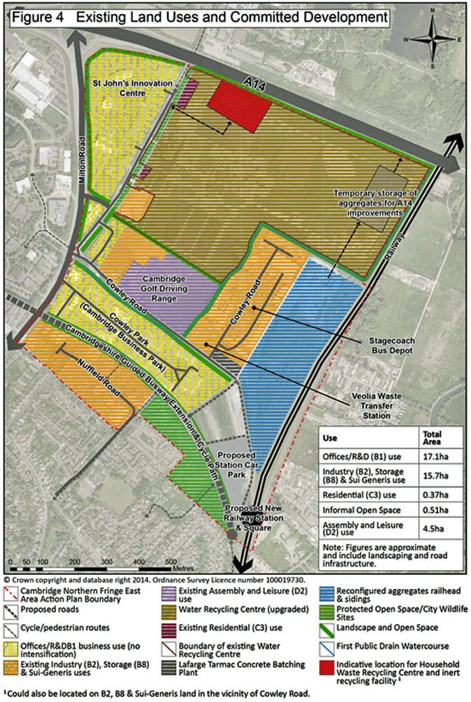
Figure 3.1: Cambridge Northern Fringe East existing land uses and committed development
3.2 Vision, Development Objectives and Development Principles
The proposed Vision for the CNFE AAP is:
Box 3.1 PROPOSED VISION
CNFE will be a vibrant and successful employment led, mixed use neighbourhood, shaped as a whole by the community, and embracing;
-
Successful regeneration of the wider area
-
modern commercial business needs and buildings;
-
sustainable urban living;
-
the proposed new railway station and extension to the Cambridgeshire Guided Busway to create new high quality transport gateway and transform the area;
-
opportunities to create a well-connected and vibrant place;
-
opportunities to enhance the environmental assets
The development will also ensure;
-
the new area is supported with the right transport, water, energy, social and community infrastructure;
-
the relocation of existing businesses and release of former industrial land for other uses is properly managed and contributes towards creating sustainable communities;
-
the regeneration and development of CNFE contributes to the wider growth agenda and shared prosperity of Greater Cambridge;
-
the continued presence of strategic aggregates railheads that will facilitate the wider growth of Greater Cambridge;
-
existing and new waste management facilities can be safeguarded/delivered (including Household Recycling Centre and inert waste recycling facility)
The development will reflect both Councils’ visions for Cambridge’s continued growth as an innovative, integrated, fair and sustainable city, whilst supporting sustainable economic growth and providing a high quality of life. The area will be comprehensively planned, but wholly integrated into the fabric of Cambridge.
The Development Principles (A-P) and Development Objectives (1-8) are presented in Box 3.2.
Box 3.2: Development Principles and Development Objectives
Over-arching objective: TO SECURE THE SUCCESSFUL REGENERATION AND REDEVELOPMENT OF THE CNFE AREA AS A NEW GATEWAY TO AND AREA OF CAMBRIDGE
Objective 1: Deliver a place that supports and fosters a strong new neighbourhood, well integrated with the wider community
A. Ensure that the needs of existing and future communities who live and work in and around Cambridge Northern Fringe East are met through development and that it is a place that can adapt to meet changing needs over time.
B. By creating a sustainable, cohesive and inclusive area through improving access to jobs, homes, open space, leisure facilities and other services within the development and to the wider community.
Objective 2: Provide a mix of land uses at densities that make best use of this highly sustainable location and regeneration opportunities
C. Increase the level of economic activity and vibrancy within Cambridge Northern Fringe East and the wider area, by accommodating an appropriate mix of office, R&D, industrial and other related employment uses supported by a range of commercial, retail, leisure, community and residential uses.
D. Focus higher density development around the transport hub and along public transport routes, taking account of the wider landscape and townscape context of the area.
Objective 3: Maximise the Employment Opportunities
E. Deliver additional flexible employment space to cater for a range of business types and sizes, and supporting a wide range of jobs for local income, skills and age groups
F. Manage the release of any redevelopment sites and where possible accommodate the existing businesses elsewhere within the CNFE area.
G. Support uses which are important to the operation of Greater Cambridge, including the strategic aggregates rail head, and the Water Recycling Centre.
Objective 4: Create a new local centre that meets the needs of the new community and which complements other facilities in the wider area
H. Create distinctive and well-connected mixed use local centre for Cambridge Northern Fringe East which provides a range facilities to meet the day to day needs of those live, work and visit the area.
Objective 5: Deliver high quality and well-designed buildings, streets and spaces that responds to the needs of the community and supports regeneration of the wider area
I. Create a distinctive local identity through development forms appropriate to the area and which create and improve the quality, appearance and function of the public realm.
J. Ensure the design, scale and location of new buildings help create streets and places that are safe, easy and convenient to navigate around, and which encourage social interaction.
Objective 6: Create an accessible, permeable, well-connected and well-integrated new neighbourhood
K. Create a gateway development that maximises the potential of the proposed new Railway Station and Cambridge Guided Busway as a transport hub.
L. Deliver enhanced connections for pedestrians, cyclists, buses, prioritise these modes to encourage a modal shift.
Objective 7: Enhance and protect the natural environment and existing and proposed open spaces
M. Create a network of green spaces and corridors to protect and enhance biodiversity and watercourses as attractive features, linking into the surrounding area.
N. Improve the setting of the area from key approaches including the route to the proposed new railway station.
O. Remediate land contamination.
Objective 8: Encourage a low carbon lifestyle & addressing climate change
P. Deliver sustainable forms of development, mitigating and adapting to the impacts of climate change.
3.3 Developing Options
3.3.1 Spatial Redevelopment
The draft CNFE AAP Issues and Options consultation document presents 4 options for the spatial redevelopment of the AAP area which have been developed using the opportunities and constraints identified (see Section 3.1).
Each option takes a more comprehensive approach to redevelopment than the previous option. The Spatial redevelopment Options are summarised in Box 3.3.
Box 3.3 Summary of Spatial Redevelopment Options
Option 1: Lower Level of Redevelopment – Creates an enhanced ‘Boulevard’ approach to the proposed new railway station, to provide a gateway to Cambridge. Focuses on regeneration of areas of more easily available land, allowing existing business and the Water Recycling Centre to stay, whilst creating a major new area for businesses. This option could be delivered early, but does little to secure the wider regeneration of the area.
Option 2: Medium Level of Redevelopment – Focuses on regeneration of areas of more easily available land, allowing existing business and the Water Recycling Centre to stay. Includes new homes and a local centre near the proposed new railway station, to create a vibrant mixed use area around the gateway. More comprehensive redevelopment improving existing areas south of Cowley Road, to integrate them into the Station area. A new road north of Cowley Road to separate out industrial traffic from the main station access. Option for Nuffield Road industrial area to change to offices / residential. This option could be delivered in the short to medium term.
Option 3: Higher Level of Redevelopment – Reconfiguration of the Water Recycling Centre onto a smaller site, with more indoor or contracted operations, subject to technical, financial and operational deliverability. Would retain the Water Recycling Centre on site but open up options for larger scale employment redevelopment and a mix of other uses. This option is complex and delivery of the full option would be in the longer term. The potential to phase redevelopment to achieve the objective of an early gateway to the proposed new railway station would need to be explored, whilst ensuring that the delivery of the full option is not prejudiced by piecemeal redevelopment. Also in this option, Nuffield Road industrial area is proposed for entirely residential development, with existing industry relocated north of Cowley Road.
Option 4: Maximum Level of Redevelopment - Water Recycling Centre relocated off site, subject to identification of a suitable, viable and deliverable alternative site being identified. This would free up a large area of land for redevelopment, and the opportunity to comprehensively address the area. This option is complex and delivery of the full option would be in the longer term. The potential to phase redevelopment to achieve the objective of an early gateway to the proposed new railway station would need to be explored, whilst ensuring that the delivery of the full option is not prejudiced by piecemeal redevelopment.
3.3.2 Proposed Policy Approaches
The CNFE AAP Issues and Options consultation document also presents a range of proposed policy approaches for consultation. The policy approaches cover the following topic areas:
-
Land uses;
-
Place making, gateway and building design;
-
Density and building heights;
-
Effective integration with the wider area;
-
Employment;
-
Housing;
-
Services and facilities;
-
Open space;
-
Transport;
-
Parking provision;
-
Climate change; and
-
Development management policies.
Detailed information about each option, along with the proposed policy approaches, can be found in Annex A.
3.3.3 Boundary extensions
The CNFE AAP Issues and Options consultation document also presents a range of options in relation to the extension of the boundary. These are assessed in Section 4.3 as part of the assessment of the Policy Approaches.