Draft North East Cambridge Area Action Plan
7.4 Safeguarding for Cambridge Autonomous Metro and Public Transport
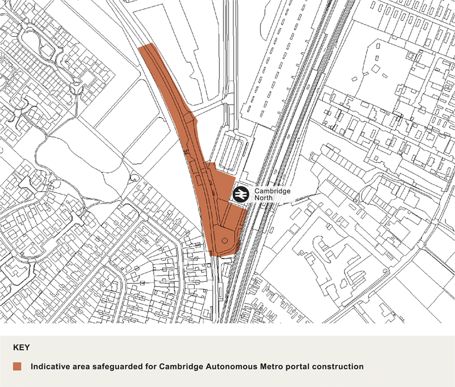
Figure 38: Map showing location of land to be safeguarded for the CAM interchange
The Cambridgeshire and Peterborough Combined Authority is promoting the development of a high quality, regional mass transit network called the Cambridgeshire Autonomous Metro (CAM). The concept consists of a tunnelled central core which will connect Cambridge station and the city centre to four portal locations. The current consultation proposal is for the northern portal to be located in the North East Cambridge area close to Cambridge North Station along the alignment of the Guided Busway. This policy ensures that land is safeguarded for this, as well as other public transport hubs.
- There was broad support for protecting corridors for sustainable movement options.
How your comments and options have been taken into account
- The central core section to be delivered by the Cambridgeshire and Peterborough Combined Authority and the Waterbeach to North East Cambridge surface section being delivered by the Greater Cambridge Partnership are in the early phases of business case development. In order to allow both projects to proceed through the appropriate stages of options assessment and route development, policies in this plan will remain suitably broad at this early stage to ensure as much flexibility is maintained as possible without stalling development of the wider site in the meantime.
(10) Policy 19: Safeguarding for Cambridge Autonomous Metro and Public Transport
Portal for the central core of Cambridge Autonomous Metro
The north portal for the central core section is likely to be located within the North East Cambridge Area Action Plan boundary. An area of land in close proximity of Cambridge North station (shown on figure 38) shall be safeguarded for the operation of the Cambridge Autonomous Metro, including land for the portal/tunnel entrance as well as for construction and maintenance.
Cambridge North Transport Interchange
Sufficient land will be safeguarded in the vicinity of Cambridge North Station to facilitate a quality transport interchange and mobility hub. The interchange shall accommodate the convergence of the three mass transit routes from the central core, the St Ives route and the proposed Waterbeach route and link seamlessly to the railway network. It will also incorporate space for first/last mile link modes to be used. The interchange will be designed in such a way that it caters for existing technologies, however it should include enough flexibility that it can be adapted in the future for emerging technologies, such as autonomous vehicles.
Mobility hubs
Mobility hubs will be provided on key walking and cycling routes, main arrival points into North East Cambridge as well as within the identified centres, across the site to enable seamless interchange between public transport and other mobility options for first/last mile links within the site. Sufficient space should be allocated to each hub to enable a mix of traditional and innovative options for the first/last mile link to be provided or to evolve as new technologies come forward.
Hubs should include space for cycle parking, including an area for dockless cycle hire cycles, good wayfinding and signposting and real time information as a minimum, but could also include space for emerging micro-mobility modes, ride-hailing services, last mile deliveries and lockers or charging points, for example.
Relevant Objective: 1, 3, 5
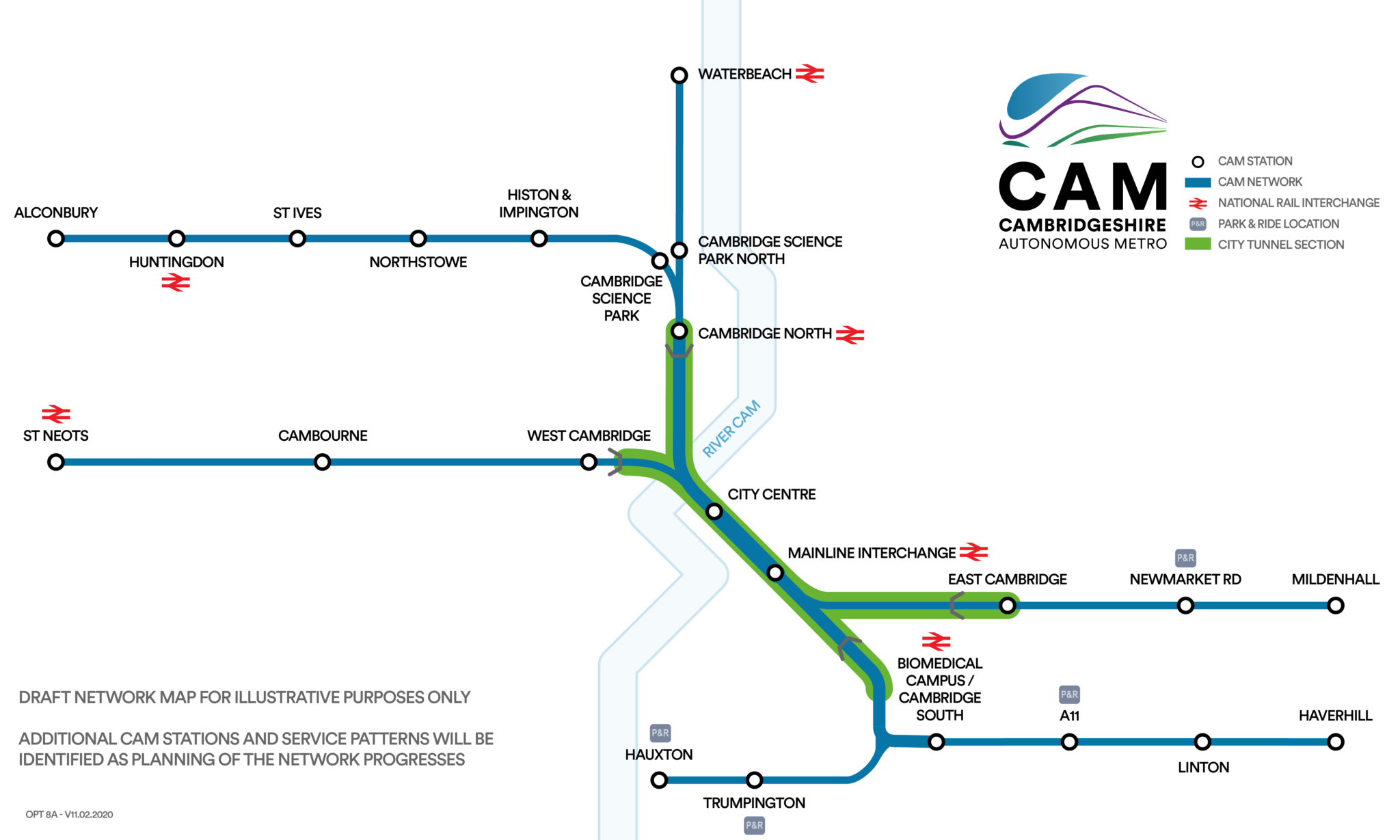
Figure 39: Indicative CAM network map. Source: https://cam.consultationonline.co.uk/the-proposals/
North East Cambridge should be designed around a network of links and connections for sustainable active modes which will provide access to a series of fully accessible mobility hubs where it is possible to interchange between high quality public transport and other modes for seamless journeys.
The Cambridgeshire and Peterborough Combined Authority is promoting the development of a high quality, fast regional mass transit network called the Cambridgeshire Autonomous Metro (CAM). The concept consists of a tunnelled central core which will connect Cambridge station and the city centre to four portal locations in the north (the current consultation proposal is for this to be located in the North East Cambridge area close to Cambridge North Station along the alignment of the Guided Busway), east, south and west of the city. These four portals will then connect seamlessly into existing segregated routes to St Ives and Trumpington Park & Ride, as well as four new segregated surface routes being promoted by the Greater Cambridge Partnership to Waterbeach, Newmarket Road, Granta Park and Cambourne, connecting to new growth sites along the way. Finally, four regional extensions are also in the early development stage, connecting onwards to Alconbury Weald, Mildenhall, Haverhill and St Neots.
The scheme is of relevance to North East Cambridge for two reasons; where the portal for the tunnelled section might be located within the plan area and how the segregated surface section from the new town north of Waterbeach feeds through the development site to the portal entrance.
To secure the benefits of the CAM, including seamless integration with Cambridge North Station, the Guided Busway and the proposed Waterbeach Mass Transit, it is appropriate for the Area Action Plan to safeguard land to facilitate delivery. As the CAM and Waterbeach to North East Cambridge projects are developed, more certainty will be given as the plan process advances.
In addition to serving the Area Action Plan area the interchange will be important in serving the sustainable transport needs of the wider catchment. The final location and design of the interchange should inform wider sustainable walking and cycling connection in accordance with Policy 17: Connecting to the wider network.
The public realm should be designed to enable seamless interface between different travel options at mobility hubs. Mobility hubs should include appropriate waiting facilities; shelter, seating and real time information, with good wayfinding and onwards journey information, cycle parking and access to dockless cycle hire schemes (in accordance with Policy 18: Cycle Parking).
- Modal share for public transport users
- Number of mobility hubs provided
- Policy 5: Strategic transport infrastructure
- Policy 59: Designing landscape and the public realm
- Policy 80: Supporting sustainable access to development
South Cambridgeshire Local Plan 2018
- Policy HQ/1: Design Principles
- Policy TI/1: Chesterton Rail Station and Interchange
- Policy TI/2: Planning for Sustainable Travel
Cambridgeshire and Peterborough Local Transport Plan – Draft Plan and Policies Annex
Cambridgeshire Local Transport Plan 2011-2031 (2015)
Transport Strategy for Cambridge and South Cambridgeshire (2014)
Making Space for People Supplementary Planning Document (Draft 2019)
Cambridgeshire Autonomous Metro Strategic Outline Business Case (2019)