The New Museums Site Development Framework Supplementary Planning Document (SPD)
4. THE EXISTING SITE
4.1 Location
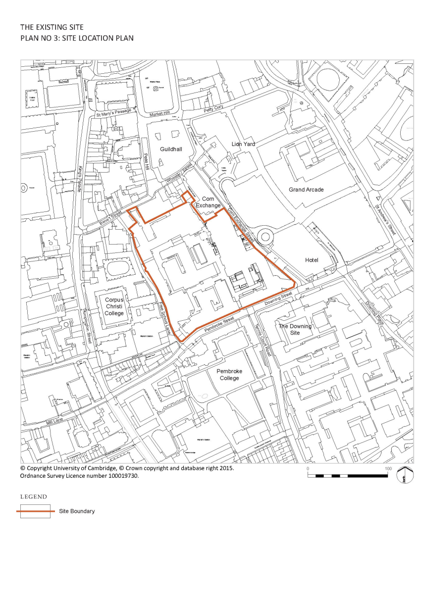
4.1.1 The NMS, which is one of the University’s central and most prominent sites, occupies an historic location in the city centre with a unique and globally important heritage. It consists of the greater part of the urban block bounded by Pembroke Street, Downing Street, Corn Exchange Street, Wheeler Street, Bene’t Street and Free School Lane. The buildings along the northern edge of the block fronting onto Wheeler Street and Bene’t Street, including the Corn Exchange, are outside the site.
4.1.2 As illustrated in Plan 3 below, the site sits between the area of College development along Trumpington Street and the commercial core of the town along St. Andrews Street. Pembroke College and the University’s Downing and Old Addenbrooke’s sites are to the south; Corpus Christi College is to the west; the Corn Exchange and Grand Arcade shopping areas are to the east and the Guildhall and Market Square are to the north. As such the site has an important role in mediating between the scale of modern commercial development to the east and that of older college buildings to the west, and between the busy vehicular highway that is Pembroke/ Downing Street to the south and the more pedestrian orientated area around the Market Square to the north.
4.2 Historical Development of the Area and its Significance
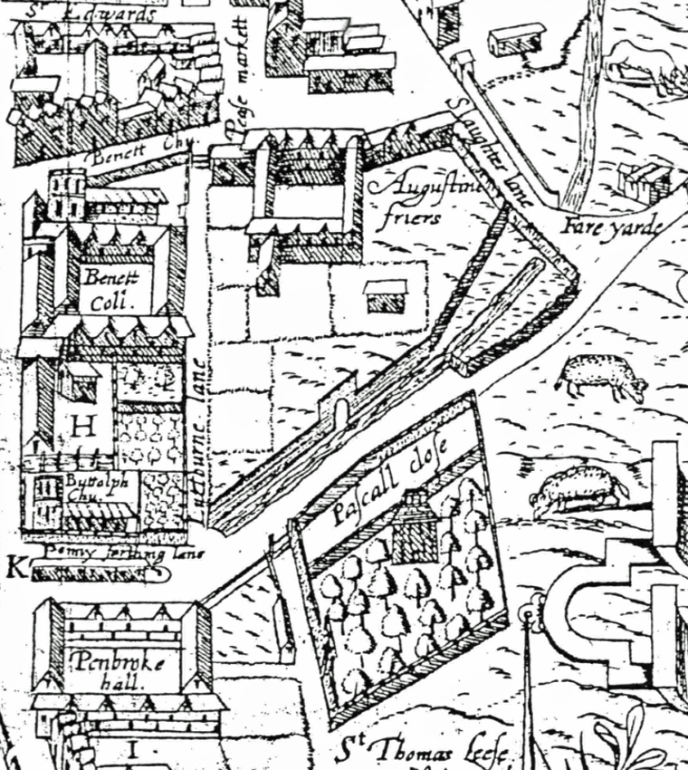
4.2.1 What is now the New Museums Site is at the heart of the medieval city of Cambridge. Its early known history is as the site of an Augustinian Friary. The Friary was founded in 129o but following the dissolution of the monasteries (1536-39) it was surrendered to the Crown. Late 16th century maps (Lyne 1574, Smith 1588 and Hammond 1592) show that significant elements of the Augustinian Friary were still evident at this time. The King’s Ditch (thought to be a Saxon defence) runs across the south-eastern corner of the site. To the north of the site, the market place was the economic and social core of the town.
4.2.2 From the 17th century onwards, overcrowding in Cambridge meant that available land within the city was increasingly valuable and was gradually developed. The former Augustinian Friary land, although still significantly open, was encroached upon along its street frontages and in the 1620s, The Free School was constructed in the southwest corner of today’s New Museums Site. The remaining elements of the former Friary buildings were subsumed into the range of courts and buildings fronting what is now Wheeler/Bene’t Street. By the end of the 17th century, despite the increasing development on the site, much of the land was still open gardens, including the triangle of land south of the King’s Ditch.
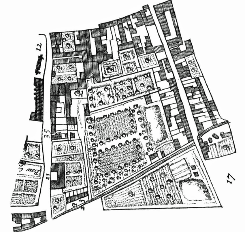
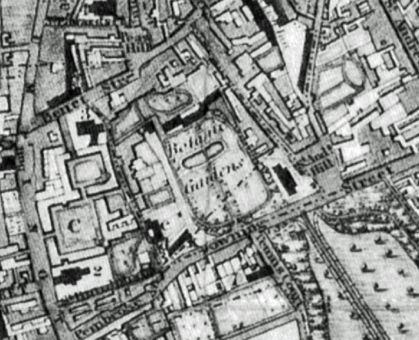
4.2.3 The 18th century marked the beginnings of an era of more substantial changes to the New Museums Site, with the development of a large mansion house (Mortlock’s house and then bank) and associated outbuildings at the north end of the site. In 1760, the majority of the site was bought by Richard Walker, Vice-Master of Trinity College for the University to provide a Botanic Garden. This was established in 1762 and was accessed from a pair of gates on Pembroke Street and a small archway along Free School Lane. By the end of the 18th century, apart from the Botanic Garden, there was no longer any undeveloped land in any quantity within the central core of Cambridge except for The Leys (marshy land) on the south side of Pembroke Street.
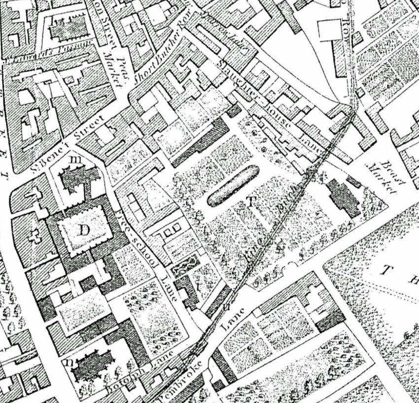
4.2.4 The enclosure of Cambridge in the early years of the 19th century, changed the wider topography of the town, with rapid development occurring predominantly to the east initially and then to the south. Within the New Museums Site, however, little changed until 1832 when buildings by Charles Humfrey were constructed for the use of the Professor of Anatomy on the corner of Downing Street and St Andrew’s Hill. The Leys, on the opposite side of Pembroke Street became the site of Downing College and construction began in 1821. 19th century maps no longer show the King’s Ditch running through the site, with the line of the ditch only dotted on Baker’s Map of 1830.
(1) 4.2.5 More major change came with the establishment of the Natural Science Tripos in the mid-19th century which highlighted the need for better accommodation for this rapidly expanding area of the University. This coincided with the realisation that the Botanic Garden was not fit for purpose and it was removed to its present site off Hills Road between 1846 and 1852 when the site was sold to the University for building ‘new museums and Lecture Rooms’ (Willis & Clark). A detailed report setting out the requirements was prepared in 1853 and in 1854 when the architect Anthony Salvin was authorised to prepare plans. However, the costs of the plans were not well received and, despite numerous changes over the years, indecision over the development of the site continued until 1863 when Salvin was finally given approval to begin construction of the central buildings on the site. These were followed by the Cavendish Laboratory (completed by 1873) and further buildings to the rear of Salvin’s Museum of Botany and along Corn Exchange Street.
(1) 4.2.6 By 1883, the site was largely in the ownership of the University, with only the northern frontage facing the present day Bene’t Street still privately owned. The Perse School became part of the site by 1890 and was remodelled to form engineering laboratories, while the Perse Almshouses were replaced in 1886-8 by chemical laboratories, lecture rooms and a porter’s lodge. Despite this development, however, a good deal of the Botanic Garden remained undeveloped.
4.2.7 The early years of the 20th century saw the enclosure of much of the Site’s boundaries with buildings including the Zoology Building which replaced earlier buildings along Pembroke Street and Corn Exchange Street. A reasonable portion of the old Botanic Garden and its entrance gates on Pembroke Street still survived however. The Examination Halls were completed in 1909 and the adjoining Arts School, designed as lecture rooms and a departmental library, was completed in 1911.
4.2.8 Scientific advances in the 20th century required new and enhanced teaching spaces and buildings were quickly erected or altered on the New Museums Site in the first half of the 20th century. Considerable consolidation of the site occurred with development on an ad-hoc basis as necessity arose and/or funding became available.
4.2.9 The site was described as ‘an incredible muddle inside’ by Nikolaus Pevsner writing in 1970. By this time, the need for comprehensive redevelopment of the site had already been established and in 1961, Denys Lasdun had published a master plan for the site, but this was not well-received by the City and County Councils largely due to the excessive height of some of the buildings. A long planning wrangle ensued before a much reduced scheme was approved in 1964 and the job passed to the newly formed Arup Associates. Only Stage 1 of the redevelopment was ever completed. This was to become known as the Arup Building and has recently been renamed the David Attenborough Building.
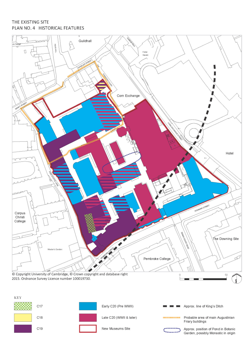
4.2.10 The erection of the Arup Building involved the demolition of almost all of the remaining Salvin buildings in the centre of the NMS. Such wholesale redevelopment was being replicated on the other side of Corn Exchange Street with the construction of the Lion Yard shopping centre and car park to which the Arup Building was originally intended to link. The historical features of the site are illustrated in Plan 4 below.
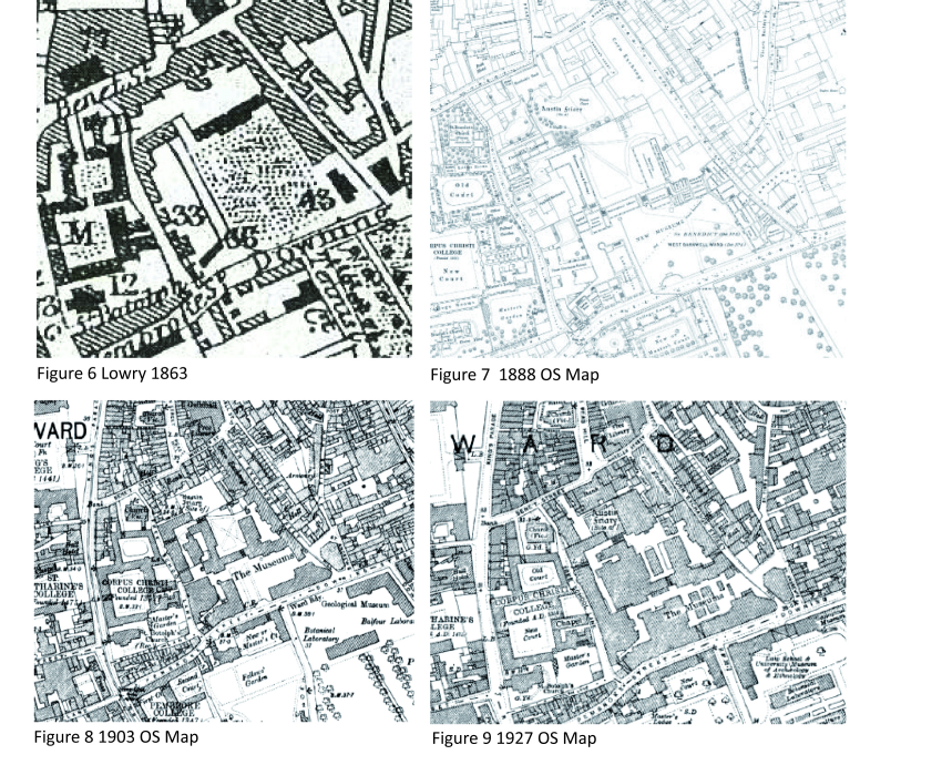
Figure 6 Lowry 1863
Figure 7 Ordnance Survey Map 1888
Figure 8 Ordnance Survey Map 1903
Figure 9 Ordnance Survey Map 1927
4.3 Existing Heritage Assets
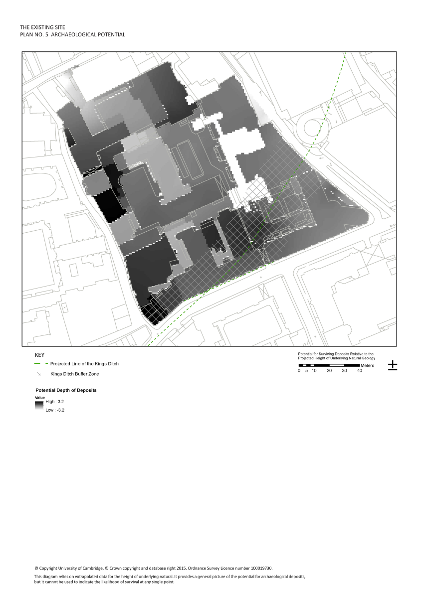
4.3.1 The site lies in an area of varying archaeological potential. There is generally considered to be low potential for prehistory remains and low to moderate potential for Roman remains. The potential for medieval remains is however high as the site’s boundaries encompass the precinct of the Augustinian Friary and the course of the King’s Ditch runs across the southeast corner of the site.
4.3.2 Plan 5 shows the predictive model of the areas in which archaeology is most likely to survive on the NMS. This deposit model has been built using extrapolated data from nearby intensively investigated sites (e.g. the Grand Arcade) together with what little formal archaeological information on the site (e.g. the excavation work undertaken before World War I) exists. This has been combined with surface, ground and basement level heights to produce the predictive model which indicates the areas where there is potential of greatest impact upon any underlying archaeological remains.
4.3.3 Archaeological remains have previously been identified within the site during the excavations for the foundations of the Arts School and Examinations Rooms in 1908 at the northern end of the site. These investigations identified Friary structures and a cemetery. In 1991, work inside the Old Cavendish Laboratory building found substantial masonry remains belonging to the friary (Cambridge Archaeological Unit Report 037, CAB 91). The site also straddles the line of the King’s Ditch which was identified in the neighbouring (to the west) Grand Arcade development and recorded as being 10-12 metres wide and 3.5 metres deep (Cambridge Archaeological Unit Report Number 800, ECB2379 and ECB2389).
4.3.4 The location of the site, within the historic core of Cambridge, encompassing the precinct of the Augustinian Friary (CHER Number 04731) and spanning the city’s defences, is highly significant and any surviving archaeological remains in this area will be key to our understanding of the early development of the town. The development of this area offers the potential to considerably advance the understanding of the layout of the friary as the precise location and form of the friary remains unclear.
4.3.5 Any investigation of and, ultimately mitigation for, the archaeology will adhere to the principles outlined in national, local and industry guidelines which favour the preservation in situ of significant archaeological remains where they have been identified. Where preservation is not required, an appropriate level of recording of the archaeology will be completed prior to further work.
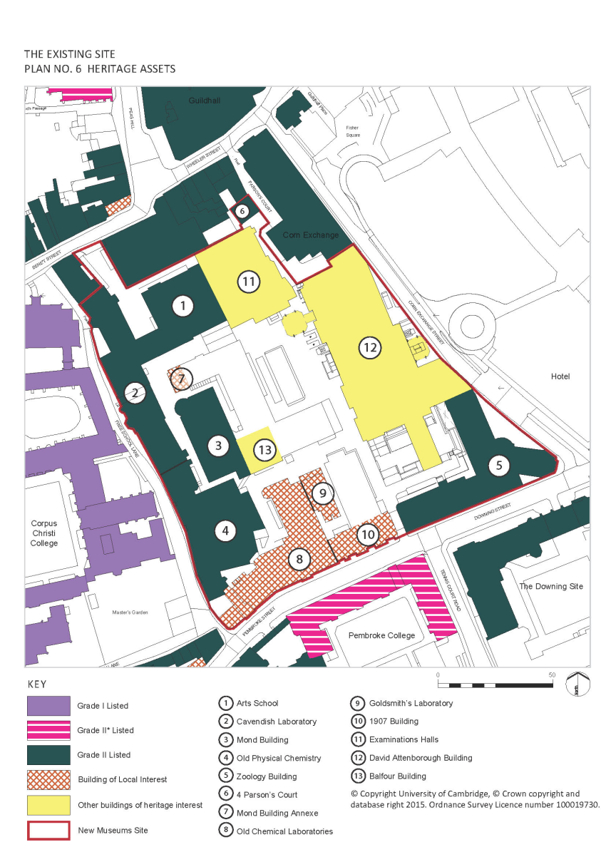
4.3.6 There are a number of Listed Buildings within and directly adjoining the site. These buildings are indicated on Plan 6. There is a statutory duty to have special regard to the desirability of preserving any Listed Building or its setting, or any features of special architectural or historic interest which it possesses (Sections 16 and 66 of the 1990 Act).
(3) 4.3.7 In summary, the Listed Buildings (all Grade II) within the site that need to be considered as part of any proposals are:
- Mond Building
- Zoology Building
- Old Physical Chemistry
- Cavendish Laboratory
- Arts School
4.3.8 The entire site lies within the Cambridge Historic Core Conservation Area which is itself part of the large Cambridge Conservation Area No.1. There is a statutory duty to preserve or enhance the character and appearance of the conservation area (conferred by Section 72 of the Planning [Listed Buildings and Conservation Areas] Act 1990).
4.3.9 The Conservation Area is a designated heritage asset, along with the Listed Buildings, and the contribution that the site makes to the character and appearance of this heritage asset must therefore be considered. Detailed assessment of the streets that the New Museums Site forms part of is provided in the Cambridge Historic Core Conservation Area Appraisal that forms part of the background evidence to this SPD: https://www.cambridge.gov.uk/historic-core-appraisal.
d. Buildings of Local Interest
4.3.10 The site and surroundings also contain a number of Buildings of Local Interest (BLIs) which are ‘non-designated heritage assets’ as defined in the National Planning Policy Framework. Works to such buildings are controlled by a specific Local Plan policy (Policy 62: Local heritage assets) in addition to national planning policy. These buildings are indicated on Plan 6.
4.3.11 The non-designated heritage assets (Buildings of Local Interest, otherwise known as “BLI’s”) within the site that need to be considered as part of any proposals are:
- Mond Building Annexe
- Old Chemical Laboratories and Porter’s Lodge
- Chemical Laboratories extension (1907 building, the frontage of the Shell Building)
- Goldsmith’s Laboratory
e. Other buildings of heritage interest
(1) 4.3.12 In addition to the designated and non-designated heritage assets, some other buildings on the site have been identified as having some heritage interest. They have no individual heritage designation, but are buildings within the conservation area:
- David Attenborough (Arup) Building
- Balfour Building
- Examination Halls
(1) 4.3.13 Building functions and uses within the wider area have changed considerably over the centuries. The site’s significance is now based on its function for University teaching (primarily originally sciences) and as a key block in the historic core of the city. The cultural significance of the site in terms of its scientific history and its previous uses as the University’s original Botanic Garden, the site of the original Perse School and as an Augustinian Friary is however lesser-known. Allied to this, is the archaeological significance of the site which may contain surviving remains of earlier phases of development including the locally important King’s Ditch.
4.3.14 The site contains a variety of building types, although they are all unified by their University use. They vary between adaptations of existing buildings, such as No.4 Parsons Court and Old Physical Chemistry, and purpose-built University buildings, although these too have all been subject to substantial remodelling to suit changing University needs.
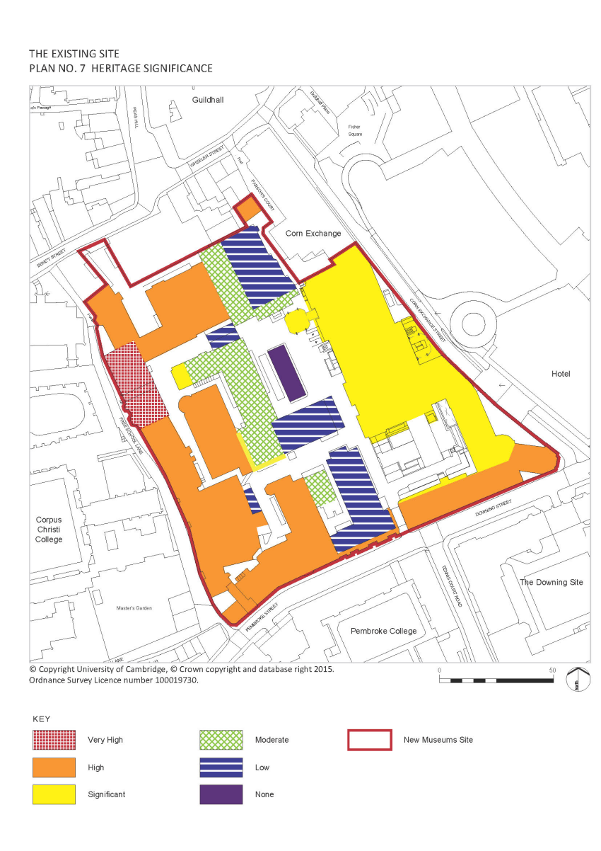
4.3.15 A detailed assessment3 of the site including each building has been completed. The level of architectural, historical and townscape significance attributed to each building is illustrated on Plan 7. Significance will normally be measured as follows:
- Very High: Usually reserved for designated heritage assets of the highest importance, i.e. Grade I and II* Listed Buildings and Historic Parks and Gardens and Scheduled Monuments.
- High: Grade II Listed Buildings.
- Significant: Non-designated heritage assets (e.g. BLIs) or Buildings of considerable townscape interest and/or intrinsic architectural or historic interest.
- Moderate: Buildings of some townscape interest and/or architectural or historic interest, but which have no formal heritage status.
- Low: Buildings which are neutral in townscape terms and/or have little architectural or historic interest.
- None: Buildings of no or insignificant townscape or heritage interest.
4.3.16 N.B. A building may move up a significance category if it is of considerable townscape importance and integral to the character and appearance of the conservation area. Similarly, a building may move down a category if it has been assessed, following investigation/research, to have lesser heritage interest than its status may imply.
(2) Plan 7 Heritage Significance
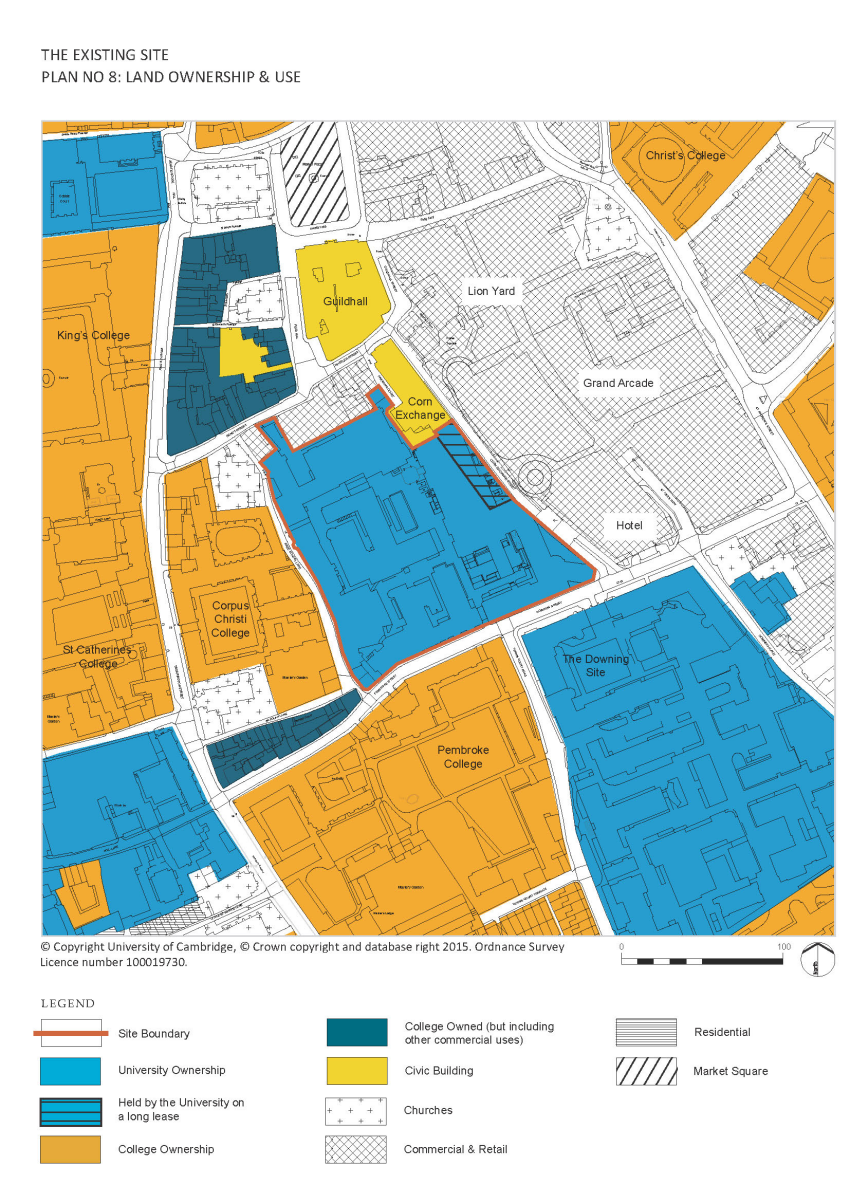
4.4 Land Ownership and Use
4.4.1 The whole of the site is either owned by the University of Cambridge or held by it on long leases, as shown on Plan 8. There are approximately fifteen different University institutions on the site including the Dept. of Zoology, the Dept. of the History and Philosophy of Science, the Dept. of Sociology and the Divisions of Biological and Social Anthropology within the Dept. of Archaeology and Anthropology. There are also a variety of support functions such as central library facilities and a number of large lecture theatres including the 450 seat Babbage Lecture Theatre; one of the largest in the University.
4.4.2 All of this is used almost exclusively for teaching and research. Two of the University’s museums, the Museum of Zoology and the Whipple Museum of Science, which are used for teaching and research but also encourage non specialist visitors, are located on the site. The University’s Sedgwick Museum of Earth Sciences and the Museum of Archaeology and Anthropology are located close by on the south side of Downing Street. In addition, the University will be providing accommodation for the Cambridge Conservation Initiative in which a number of non-university conservation organisations will be tenants from 2016.
4.4.3 The site is surrounded by a wide variety of land uses as is typical of Cambridge city centre, with Colleges, shops, restaurants, businesses and civic and cultural amenities all within a short distance.
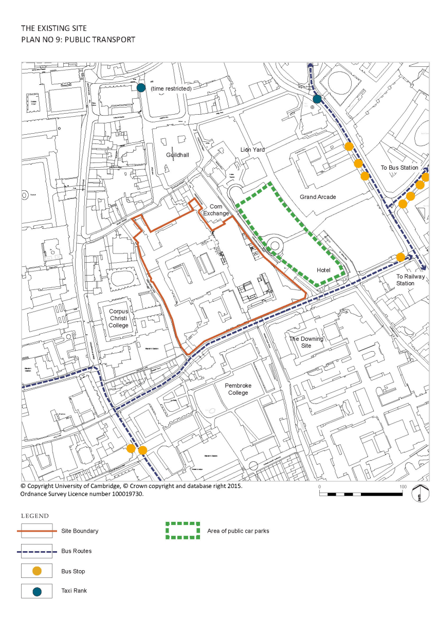
4.5 Transport Connections
4.5.1 The site is well connected to the wider city beyond the immediate city centre in terms of public transport, as shown on Plan 9. The Trumpington Park and Ride bus stops on Downing Street itself, the Uni 4 passes the end of Pembroke Street along Trumpington Street to the other main University sites and the main bus station is only a few hundred yards away. A taxi rank is also nearby on St Andrews Street and the railway station is approximately 1 mile away with links to London, Stansted Airport and other major transport hubs.
4.5.2 Downing Street and Pembroke Street are a part of the main one way traffic route through the town centre and provide access to Corn Exchange Street from which the city centre car parks are reached. As such they are busy roads and queues frequently form along these roads along the southern edge of the site. A pelican crossing links the site to the University’s Downing Site to the south east but the quality of the environment for pedestrians - with narrow pavements of inadequate width to accommodate the numbers of users, especially at busy times, and those with particular needs - could be improved.
4.5.3 Large vehicles, including articulated lorries, use the route along Pembroke Street, Downing Street and Corn Exchange Street to service the Corn Exchange and the Arts Theatre as well as commercial premises along Wheeler Street and Benet Street.
4.5.4 There are contraflow cycle lanes on all the surrounding streets. Cycle hoops are located on Free School Lane.
4.6 Access into the Site
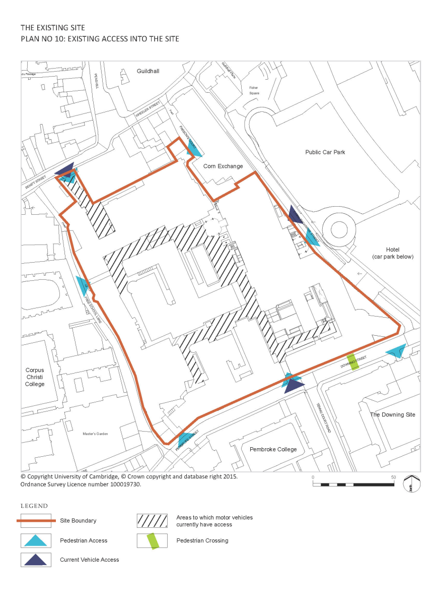
(1) 4.6.1 Access into the site is currently very poor, as highlighted by Plan 10. The main entrance is through the arch in the Zoology Building on Pembroke Street, almost opposite Tennis Court Road. This provides the only vehicular access to the interior of the urban block and there are significant problems caused by the needs of different users. This is a particular problem in term time when there are large numbers of undergraduate students accessing the large lecture theatres on the site.
4.6.2 Other places for pedestrian access to the site for the public are via the entrances in the Old Cavendish Laboratory at the northern end of Free School Lane, the Heycock Wing at the south west corner of the site on Pembroke Street, and via an alley adjacent to the Corn Exchange.
4.6.3 A service yard with car parking spaces is accessed from the north via Bene’t Street. Members of the University can access the NMS through the Arts School building, the entrance to which is via this yard.
4.6.4 There is a layby for the delivery of goods on Corn Exchange on the east side of the David Attenborough Building.
4.7 Quality of the External Spaces and Movement within the Site
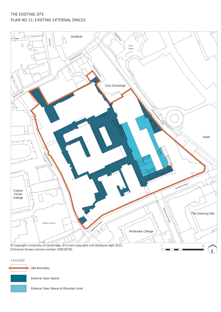
4.7.1 Plan 11 shows the location of external spaces on the site. Most of the external space on the ground level of the site is given over to parking for motor vehicles though cycle parking stands have been introduced to some of these spaces as part of the University’s plan to generally reduce car parking and increase cycle parking provision. None of this space can be described as a public realm though it is publicly accessible. The David Attenborough Building was designed, as was typical at the time, with a raised public podium to separate the public- pedestrian realm from the service areas on the ground level. This was not successful due to the lack of connectivity and continuity with the wider city and to the lack of facilities on the podium.
4.7.2 Circulation within the site is chaotic due to the piecemeal development, the ad hoc nature of the external spaces and the prominence given to motor vehicles. Wayfinding is very difficult and public access to the Museums is confusing. Current work to the David Attenborough Building is improving this through the construction of a new stair up to the podium and a new external stairs from Corn Exchange Street.
4.7.3 Access and movement around the site is particularly poor for those with limited mobility due to the presence of motor vehicles though the site is fundamentally level. Again, improvements are being made through the works to the David Attenborough Building.
4.8 Landscape Features and Ecology
4.8.1 As can be seen from Plan 12, there are no significant landscape features on the site other than a small area of garden at the northern end of Free School Lane outside the Old Cavendish Laboratory. Within the interior of the block there is a self-seeded tree at the southern end of the Mond Building and some planting, including a Birch tree, in a raised bed adjacent to the Old Physical Chemistry Building. None of this has high ecological value. The work to the David Attenborough Building includes a green roof designed to encourage biodiversity on the site and an area of planting with a tree on the raised podium outside the new entrance foyer to the Museum of Zoology, and on Corn Exchange Street. Bird boxes, bat boxes and ‘insect hotels’ are also included in these works.
4.9 Townscape
4.9.1 The quality of the public realm within the site, as illustrated in Plan 12, has been identified as a key issue throughout the latter half of the 20th century to the present day. The problem is the piecemeal way in which the interior of the site developed with buildings erected as needs and budgets were identified rather than to conform to any particular plan.
4.9.2 Some of the buildings within the site are rather utilitarian, whilst others have positive features, but in many respects, the problem is how the buildings relate to each other. The quality of the spaces is extremely poor with many buildings extended or modified to the rear to accommodate all the necessary plant, flues, ducting and fire escapes, leaving little intervening space.
4.9.3 The space which does remain is dominated by car parking and utilitarian tarmacadam surface treatments to allow vehicular access, at the expense of pedestrians and cyclists. Soft landscaping within the site is limited to the small raised courtyards outside the Zoology Museum, the tree adjacent to the Balfour Building, some shrubs in the south west corner of the site and the area of planting on Free School Lane outside the Raleigh Wing. The settings of the heritage assets and the interior of the site’s contribution to the conservation area is therefore extremely poor.
4.9.4 The exterior of the site, the south and west-facing street frontages, however contribute hugely to the townscape character of Free School Lane and Pembroke/Downing Street. The buildings of the site are an integral part of the townscape of these streets, complementing the buildings of the Downing Site and Pembroke and Corpus Christi Colleges. This is slightly marred by the large box addition to the roof of the former Chemical Laboratories. In common with the interior of the site, soft landscaping is limited, and there is only a small patch of shrubs outside the Rayleigh Wing, reputedly the last remnant of the original Botanic Garden.
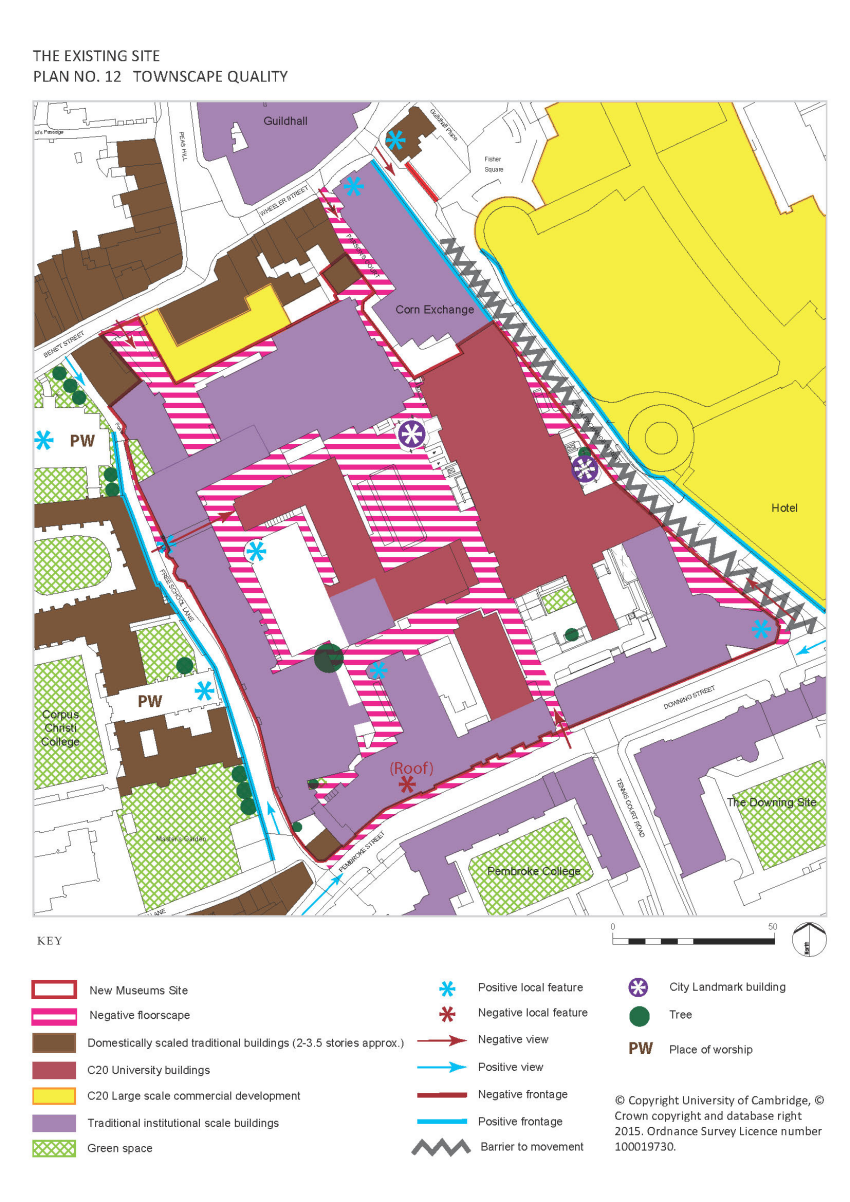
4.9.5 The site’s contribution to the north, to Bene’t Street and Wheeler Street (including Parson’s Court) is far more limited as the site has no direct frontage onto these routes except for No.4 Parson’s Court. Only poor quality glimpsed views are possible of the site’s buildings from these streets.
4.9.6 The site’s contribution to the east, to Corn Exchange Street, is entirely generated by the monumentality of the David Attenborough Building which contributes to the ‘service route’ character of this street.
4.10 Roofscape
4.10.1 At roof level, aside from the towers of the David Attenborough Building, the site does not feature strongly in the city’s skyline, and there are limited points outside the site from where it is seen at a raised level.
4.10.2 In street views, the traditional, largely Victorian/Edwardian properties of Free School Lane and Pembroke/ Downing Streets with their variety of pitched roof forms contributes positively to the character of these streets. The notable exception is the large later ‘box’ addition on top of the Old Metallurgy Building, which hides the attractive ventilation shaft of this building.
4.10.3 Along Pembroke/Downing Streets, the variety of pediments that break the strong parapet line is a particular feature of the built form on this route, and echoes that of the Pembroke College buildings on the opposite side of the road. The stepped gables of the remodelled Perse School and the cupola of the old hall within this complex are attractive features of Free School Lane’s roofscape, complemented by the use of half-dormers on the Old Cavendish Laboratory.
4.10.4 Views across the site from raised points nearby, including Great St Mary’s Church tower and the Grand Arcade multi-storey car park, show the variety of roof forms within the site. Chimneys, skylights, attic windows and a mixture of gabled/hipped roofs are prevalent amongst the traditional properties, whilst the later 20th century buildings have either flat roofs or mansard roofs and a large number of flues or other paraphernalia. However, dominating the eastern part of the site is the considerable mass of the David Attenborough Building.
4.10.5 In common with much of the historic core, the prevailing feature of the site’s roofscape is its variation, a consequence of 150 years of continual development. It diverges between single storey to eleven storeys and traditional pitched roof forms and materials to flat roofs; all across one city block of approximately 1.5ha.
4.11 Infrastructure
4.11.1 The infrastructure on the site and the servicing of individual buildings on the site has developed in a piecemeal fashion over time. The systems are therefore complex, confused and inefficient and as a result very difficult to maintain and adapt.
4.11.2 Energy use is high due to the nature of the various buildings on the site.
4.11.3 There is no attenuation of storm water drainage.
3 The New Museums Site Historic Environment Analysis (Beacon Planning Ltd. 2015)