The New Museums Site Development Framework Supplementary Planning Document (SPD)
5.0 PARAMETERS FOR CHANGE
5.0.1 This section of the SPD identifies the constraints and opportunities that will shape how future development of the NMS will take place.
5.0.2 A total of four key "parameters" are set out here. They include connectivity and movement; open space and the public realm; built form; and sustainability. Proposals on the NMS site should be in broad compliance with the parameters as set out herein.
5.1 Connectivity and Movement
5.1.1. The NMS is the larger part of an existing urban block which has been formed through the long historical development of the city. The block makes an essential contribution to the Central Conservation Area through its definition of urban structure and through the architectural quality and variety of the frontages of the buildings around the perimeter, particularly along Downing Street and Free School Lane. Its fundamental form and identity should remain unchanged.
(1) 5.1.2 However, the block fails to contribute to the wider context in two crucial respects. Firstly its perimeter is very closed and does not engage with the surrounding streets; and secondly, the interior of the site provides no clear routes or open spaces of any quality to contribute to the grain and continuity of the wider public realm.
5.1.3 Opportunities should be explored to improve the quality of the public realm outside the boundaries of the site and to better the relationship of the NMS to the wider city centre more generally and to the University’s other city centre sites more specifically. This will require consideration of improvements to the surrounding streets as part of the public realm and as part of the city centre traffic management plans. Cambridgeshire County Council, on behalf of the City Council and other stakeholders, entered into the City Deal with central government in 2014 to help deliver economic benefits through improvements to transport infrastructure in and around the city. Along with improvements to the public realm which can be made by the University of Cambridge, the City Deal offers a potential opportunity to improve wider accessibility of the city centre to the benefit of the NMS site.
5.1.4 A recent study known as the Cambridge City Centre Access Study – DRAFT (January 2015) prepared by Beacon Planning and led by the City Council also recommended areas for improvement within and around the city centre. Recommendations from this study will be considered further in respect of how improvements in the surrounding public realm can provide mutual benefit to the NMS and the public using surrounding streets. The report and relevant council meeting minutes (Community Services Scrutiny Committee, 19 March 2015) related to this study may be found at: http://democracy.cambridge.gov.uk/ieListDocuments.aspx?CId=176&MId=2574&Ver=4
(1) 5.1.5 Corn Exchange Street is the vehicle entrance and exit to the main city centre car park which is part of the Grand Arcade. If it were possible, this location would benefit from increased areas of pavement in order to improve the safety of pedestrians, (such as those being implemented at the time of writing as part of the works to the David Attenborough Building), but it is unrealistic to imagine it becoming a principal place of arrival for pedestrians or for it to be more than the service road it has become.
5.1.6 Free School Lane on the other hand is a unique and high quality part of the Central Conservation Area. It provides a pleasant and enjoyable place in which to experience many Listed Buildings and the scale of a medieval street with views of St Benet’s Church and King’s College Chapel beyond. The entrance to the Whipple Museum however, though charming in its scale, is unsatisfactory in terms of access. Opportunities to address this issue and to make the Museum more visible should be explored.
5.1.7 Wheeler Street, to the north, is a busy and energetic part of the city full of character with a number of retail units, public houses and St. Benet’s Church. The NMS faces onto the street with a nondescript yard currently used as a car park and service area. This should be improved so that the University’s presence in the city is made more visible and the street scene improved, in this case especially from Bene’t Street.
5.1.8 Pembroke Street and Downing Street form a complex place which is an important part of the city centre, with many buildings of high quality and its own particular spatial and architectural character. Four of the University’s internationally important museums are located along the street, as well as one of the largest hotels in the city, and it forms a key link between the mostly University and College focussed area along Trumpington Street and the commercial area along St Andrews and Regent Streets.
5.1.9 Pembroke and Downing Streets are, however, dominated by vehicular traffic flows resulting from the current city centre traffic system, with particularly congested junctions at the intersections with Trumpington Street and with Tennis Court Road.
5.1.10 A future, wider re- consideration of city centre traffic movement might address the various issues posed by this problem but, in the specific context of the NMS, it is the area defined by the existing entrance loggia to the Downing Site to the north and east, and the junction with Free School Lane to the south and west, that is crucial.
(2) 5.1.11 The adoption of a less conventional approach to the design of the highway in this area and the prioritisation of pedestrians would not only facilitate better and safer movement between the sites for the large numbers of members of the University who travel between them, but would also better connect the Museums and create opportunities for them, and the University generally to engage in the wider public realm. Such a space would need very careful design to make drivers aware of the changed priorities and their responsibilities. The design of the paving, the introduction of trees and a system of controlling traffic queuing for the car park during busy periods could all potentially play a part in this.
(1) 5.1.12 There is a potential opportunity to introduce small specialist retail outlets at ground level along Pembroke Street which would help activate this street scene. The appropriateness of any outlets would, however, need to be tested at a detailed level, in particular in respect of appropriateness of fit with the heritage assets and accessibility in this part of the site.
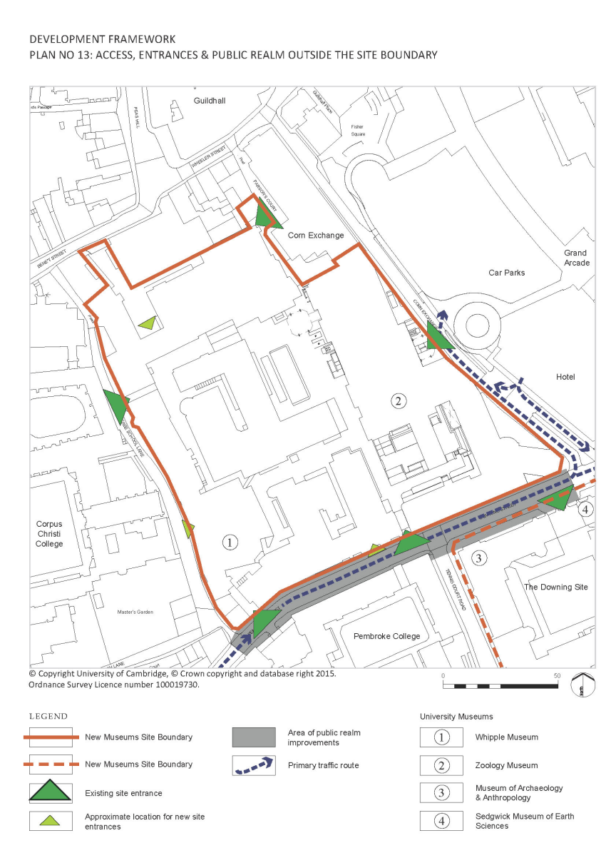
(18) 5.1.13 An increase in the permeability of the site for pedestrians is critical and must be delivered as part of the redevelopment of the site. This can only be achieved through the creation of new entrances, and, as identified on Plan 13 specific opportunities which exist are as follows:
- Pembroke Street. Pembroke Street is the main and busiest public street relating to the NMS and as such a primary public entrance, or ‘front door’, to the site is required. The street frontage is an important part of the central conservation area but sensitive and creative architectural design could engage with the existing buildings to make this frontage more permeable at ground level.
- Off Bene’t Street through the yard onto which the Arts School faces. (Bene’t Street Yard). This existing yard is currently used as a car park and the view into it from Bene’t Street is terminated by the almost blank and very plain back wall of the Cavendish Laboratory. Though this is a Listed Building, existing window openings could be sensitively adapted and possibly enlarged to provide a new entrance with a view into the site in association with general environmental improvements to the yard and the way it engages with the street.
- Free School Lane. The current public entrance to the Whipple Museum is unsatisfactory for both members of the public and the Department of the History and Philosophy of Science in which it is located. Access for disabled and those visiting as groups is via a lift which is located at the rear of the building accessed from within the site itself. If done with sensitivity to the existing buildings in this location, an opportunity exists in the notional gap between the geometries of the Old Physical Chemistry Building and the Phoenix Building to create a new entrance leading into a new foyer. This would separate the public and department entrances and improve disabled access while at the same time forming a new entrance to the site as a whole.
There are limited opportunities for improvement to the existing access way to the site via Parson’s Court at the northern end of the site due to its use as a spill out space for the technical and ancillary areas of the Corn Exchange, though this route will be maintained.
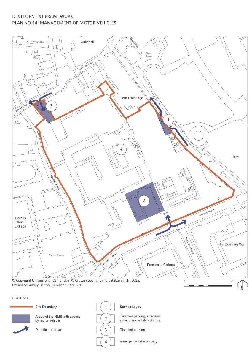
5.1.14 Access to the site by motor vehicles shall be limited to the minimum requirements to meet those needs which cannot be met in any other way. Access control mechanisms will ensure that motor vehicles do not casually enter the site without prior permission. Movement within the site will be limited to have a minimum impact on the layout and quality of the public spaces with parking constrained to those areas adjacent to the vehicular access points. The proposed arrangement of managing motor vehicles is shown on Plan 14.
5.1.15 Service vehicles will as a matter of course be directed to the layby and goods in/out facility on the lower ground floor of the David Attenborough Building on Corn Exchange Street. Specialist service vehicles will be permitted to enter the site when necessary by prior arrangement.
5.1.16 Waste from the various University institutions on the site will be stored in a central location from where it can be removed by specialist vehicles accessing the site via the Pembroke Street arch.
5.1.17 Disabled parking spaces will be provided in both Bene’t Street Yard and at the entrance to the site from Pembroke Street.
5.1.18 Access to the site for emergency vehicles will continue to be limited by the size of the existing entrance through the archway leading from Pembroke Street. The movement of a fire tender able to enter the site through the existing arch around the site will be facilitated to allow fire-fighting. Dry horizontal ‘risers’ will be provided where it is not possible to provide tender access.
5.1.19 A small number of parking spaces for University vehicles provided for the use of staff on essential business and available via a central booking system will be provided near the main vehicle entrance from Pembroke Street.
5.1.20 Access and parking facilities for bicycles will be improved. Parking facilities will be provided in a manner such that they do not dominate and overpower the open spaces. Underground parking will be provided where possible either in existing basements or through the use of proprietary systems with clusters near the main entrances. Imaginative and creative solutions to this issue will be encouraged.
5.1.21 Ancillary facilities such as showers, lockers and basic maintenance facilities (compressed air) should be provided at key points and where possible in new development.
5.2 Open Space and the Public Realm
a. Public Realm within the site
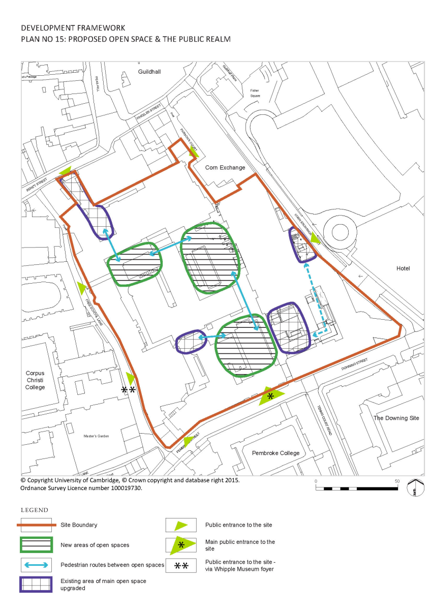
(1) 5.2.1 The creation of high quality open spaces within the site is also a priority. These spaces should provide the clarity, cohesion, continuity and spatial identity for the site which it is currently lacking. They should also provide more appropriate settings for new buildings and the Listed Buildings on the site and make the heritage of the site more accessible and visible.
(5) 5.2.2 Opportunities exist for three new main primary open spaces (referred to as A, B and C respectively on Plan 2: Illustrative Masterplan and as shown on Plan 15 below):
- An entrance court on the site of the existing Shell Building. This would be the main reception space to the site accessed from Pembroke Street. It should be a place of welcome and orientation and should be able to cope with the numbers of people and groups of people visiting the site and the Museums on it. The foyer to the Museum of Zoology and the café on the podium of the David Attenborough Building (under construction at the time of writing), as well as the foyer of the Whipple Museum, should address and be accessed from this space. The space should also have a scale appropriate to this part of the site as determined by the monumental character of the David Attenborough Building and the frontages of the buildings facing onto Downing Street and Pembroke Street.
- A central court in the existing area between the David Attenborough Building, Cockcroft, Austin and Examinations Hall buildings .This should be the heart of University life on the site and form an open air ‘foyer’ to the Babbage Lecture Theatre, which is one of the two large University lecture theatres in the city centre, and the Examinations Halls. The space should also be used to create terraces or steps that could mediate between the ground level and the raised podium of the David Attenborough Building, and mitigate its unwelcoming face at ground level.
- A third court. A welcoming open space, reached and visible through the existing archway from Free School Lane and a possible new entrance from Bene’t Street, could be created to form a new and appropriate setting for the entrance drum to the Mond Building. The character of this space should reflect the smaller scale of the buildings and urban grain in this part of the city.
5.2.3 The site is the property of the University and as such access to the site, including the open spaces, will be controlled for reasons of security and safety. In general however, they will be open to the public and will form a part of the public realm of the city. Even spaces such as the Babbage Lecture Theatre, which will generally be private spaces for University teaching, will on occasion become a part of this public realm at certain times when, for example, they become venues for public lectures; a function that will be encouraged and facilitated by the redevelopment.
5.2.4 Both open and enclosed secondary and tertiary spaces, of a smaller scale and less public nature, should also be created as a continuation of the public realm, thereby spatially linking institutions within the University and providing variety to the grain and scale of the townscape.
(1) 5.2.5 The design of open spaces should be developed to relate and give structure to existing facilities and buildings. Consistent specification of paving materials, furniture and fittings and the detailed design of build elements such as steps, ramps, raised planters and tree pits should allow for a coherent approach to open spaces across the site.
(1) 5.2.6 The new open spaces should be planted with trees in such a way that they contribute to the spatial structure of the place. The areas underground should be used for storm water attenuation and surface water features relating to this, which would make an important contribution to the quality of the environment, should be incorporated where possible.
5.2.7 External lighting should be discrete to avoid light pollution and optimise energy use but should nevertheless fulfil its functions in creating a safe and legible environment through the illumination of key features such as entrances, art work, primary pedestrian routes and vistas.
(1) Plan 15 Proposed open space and the public realm
5.2.8 Public art should be delivered across the site in a holistic and coherent way and a strategy to deliver this will be submitted with the first major proposal for redevelopment.
5.2.9 Public art should engage with the site’s heritage and its continuing importance to public life and knowledge.
5.2.10 Public art should contribute to other important issues addressed in this SPD such as the quality and cohesion of the public realm, the creation of comprehensible and high quality external spaces, public engagement and interpretation of heritage.
5.2.11 The site has an extraordinarily rich history but this is largely invisible or inaccessible except for the presence a number of wall plaques. The heritage embedded within the site, including its archaeology; use as a botanic garden;contributions to the history of science and the architecture of special interest, will be made more accessible by the creation of a significant public realm, as described in previous sections, and through public art and information systems including technologies such as smart phones and Wi-Fi. The history of the University as well as the current and future contributions being made by those working on the site will also be made more accessible in this way.
5.3 Built Form
5.3.1 The existing buildings on the site have suffered from the need to adapt them to modern functional requirements for laboratories and other specialist uses over a long period of time. The University’s initiatives in relocating the science orientated departments that have a need for such facilities to West Cambridge and for re-using the buildings as accommodation for the Humanities and Social Sciences, which are largely desk based activities, provides an opportunity to remedy the situation.
5.3.2 The plethora of plant mounted on the rear elevations of the buildings, for example, should be addressed as should inappropriate roof top additions and the current situation in which buildings around the perimeter of the site now turn their backs to their surroundings as a result of functional needs within, with many blacked out windows. Creative adaptation and restoration of the interiors of these buildings would improve their contributions to the public realm outside and is to be encouraged. Opportunities to improve the relationship of the brick plinth of the David Attenborough Building to its surroundings should be explored.
5.3.3 Existing buildings will continue to determine the overall visual character of the site but the creation of new open spaces and the introduction of new facilities within new buildings within the site will require the demolition of some structures and, in turn, the re-provision of useable space elsewhere on the site.
(1) 5.3.4 Opportunities also exist for new buildings to replace existing buildings of a lesser quality. These are primarily in the centre of the site where much ad hoc development took place in the mid-twentieth century to meet the urgent space needs of the Dept. of Physics and where the contribution of the townscape to the Historic Core Conservation Area is negligible or non-existent.
(1) 5.3.5 New buildings should be considered firstly in relation to the structure of the external spaces and the need to provide natural light and sunshine into the interior of the site. The height of buildings in this respect is of key importance and proposals for new buildings will need to demonstrate their impact on the quality of the external spaces through daylight and sun path modelling. New buildings must also be of a height appropriate to the historic context of the site and not “compete” with existing buildings and the site in its immediate and wider townscape.
5.3.6 Entrances should be orientated towards the public spaces and ground floors should contribute to the activity and life of the public realm where appropriate.
5.3.7 Roofs should be designed to add to the grain and variety of the city roofscape and roof top plant should be avoided if possible. Any new roof plant should be positioned discreetly on roof tops and screened appropriately.
5.3.8 New buildings on the site should be designed to a high standard and to address contextual issues including scale, size, the use of materials and the way in which openings in facades are formed.
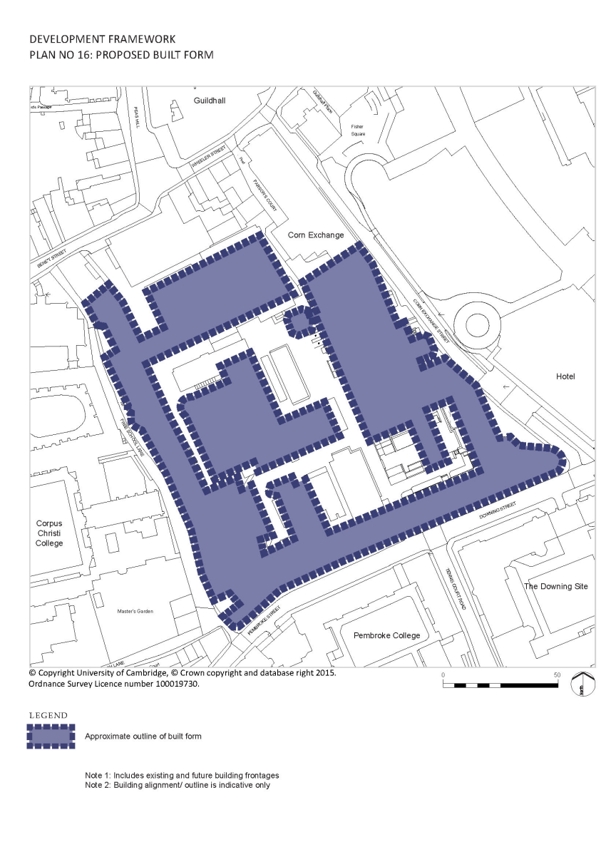
(1) 5.3.9 The proposed built form is annotated with the existing and proposed building footprints on Plan 16.
5.4 Sustainability
(1) 5.4.1 Creating a sustainable place within the city should be a priority underpinning all initiatives to redevelop the site and a holistic and site wide approach, addressing environmental, social and economic issues is required. These should include;
- Health and well-being of occupants and visitors
- Energy efficiency of new buildings
- Design for climate change
- Water use
- Flood mitigation
- Use of materials and resources
- Waste
- Employment opportunities
- Pollution
- Transport and mobility
- Conservation of heritage assets in a manner appropriate to their significance
5.4.2 Specific initiatives to be included are:
- A Combined Heat and Power network driven from a site wide energy centre
- A site wide storm drainage scheme to attenuate storm water run-off from the site is to be implemented using green roofs and storage of water below open spaces
- Reuse of existing structures and materials arising from the works itself
- Specification of materials with a view to social and environmental impacts
- Initiatives and infrastructure in support of sustainable modes of travel
- Technologies, especially photovoltaics to generate renewable energy where appropriate on new roofs
- Improved infrastructure reducing risks of pollution and noise
- Design of new buildings using passive environmental control principles, natural ventilation and natural daylighting
- Improved air quality and decrease in noise pollution through the management of vehicles and plant
- Conservation of heritage assets in a manner appropriate to their significance
5.4.3 Though standard industry-wide assessment methods should be used where appropriate (such as in the construction of new buildings for example), a less rigid approach should be considered with regard to existing buildings and the site as a whole. Specific issues should be addressed and benefits sought though the setting of real and challenging targets and through the monitoring of achievements against those targets rather than through the application of prescribed criteria, which might not be relevant in this unique location. Other sections of this document are also relevant to the wide agenda of sustainability.
5.4.4 There are many opportunities for the ecology and biodiversity of the site which currently has very low ecological value. Initiatives should be developed in the context of wider plans for improvements to the ecology and biodiversity of the city centre and to locations situated within Cambridgeshire. Such initiatives would be particularly appropriate given the site’s history as the University Botanic Garden.
These should include the provision of;
- Trees and planting throughout the site where appropriate
- Water resources at both ground and higher levels ( in association with SUDS and landscape features where possible)
- Nesting opportunities for a variety of bird and bat species
- Habitats for insects
5.4.5 New and existing flat roofs provide a specific opportunity to improve the ecology of the site and to contribute to the general increase in the biodiversity of the city centre. The creation of calcareous grasslands, which are a feature of the region, should be considered together with neutral grassland environments. A variety of substrates and microclimates have a part to play and both green and brown roofs, which support much needed habitats for invertebrates, are desirable. The installation of photovoltaics on roofs should not prohibit the creation of planted roofs as the shade will add variety to the environmental conditions.
5.4.6 Opportunities for the creation of green walls comprising climbing plants should be explored in north and east facing walls to provide nectar sources for invertebrates and cover and night roosting sites for birds.
5.4.7 Initiatives that link the provision of ecological enhancements with the public art strategy should be explored.
5.4.8 Infrastructure on the site should be improved where possible through rationalisation and consolidation of services in order to ensure fitness for purpose and minimisation of disruption in the future.
5.5 Phasing and Implementation
5.5.1 The New Museums Site is home to a number of University departments and Museums, and learning and teaching spaces, and most of the site will remain in operational use as development comes forward. It is likely that change will be delivered over a number of years and phases. The Masterplan identifies discrete areas on the site where development is likely to come forward at the same time.
(1) 5.5.2 The phasing of development of these areas will need to be determined with detailed reference to the specific nature of the existing conditions, the proposals for change and the need to maintain a reasonable environment for those continuing to travel, live and work in the vicinity.
5.5.3 It is essential that each phase is approached as part of the larger redevelopment of the site and that design is focused on the quality and coherence of the site as a whole.