Mill Road Depot Draft Planning and Development Brief SPD
4 DEVELOPMENT PARAMETERS
4.1 OVERVIEW
4.1.1 This chapter provides planning and design guidance on how the development principles will be used to guide future planning applications. In some cases the wording is more prescriptive, and this is reflected in the language with words such as “will” and “should”. In other cases the guidance is more discretionary and illustrative, providing a vision and aspirations for future development.
(1) 4.1.2 Figure 26 summarises the broad scope and status of the material. The main guiding principles are defined in a series of "parameter" drawings with supporting text. These are supported by a range of illustrative drawings which depict how the principles could be realised.
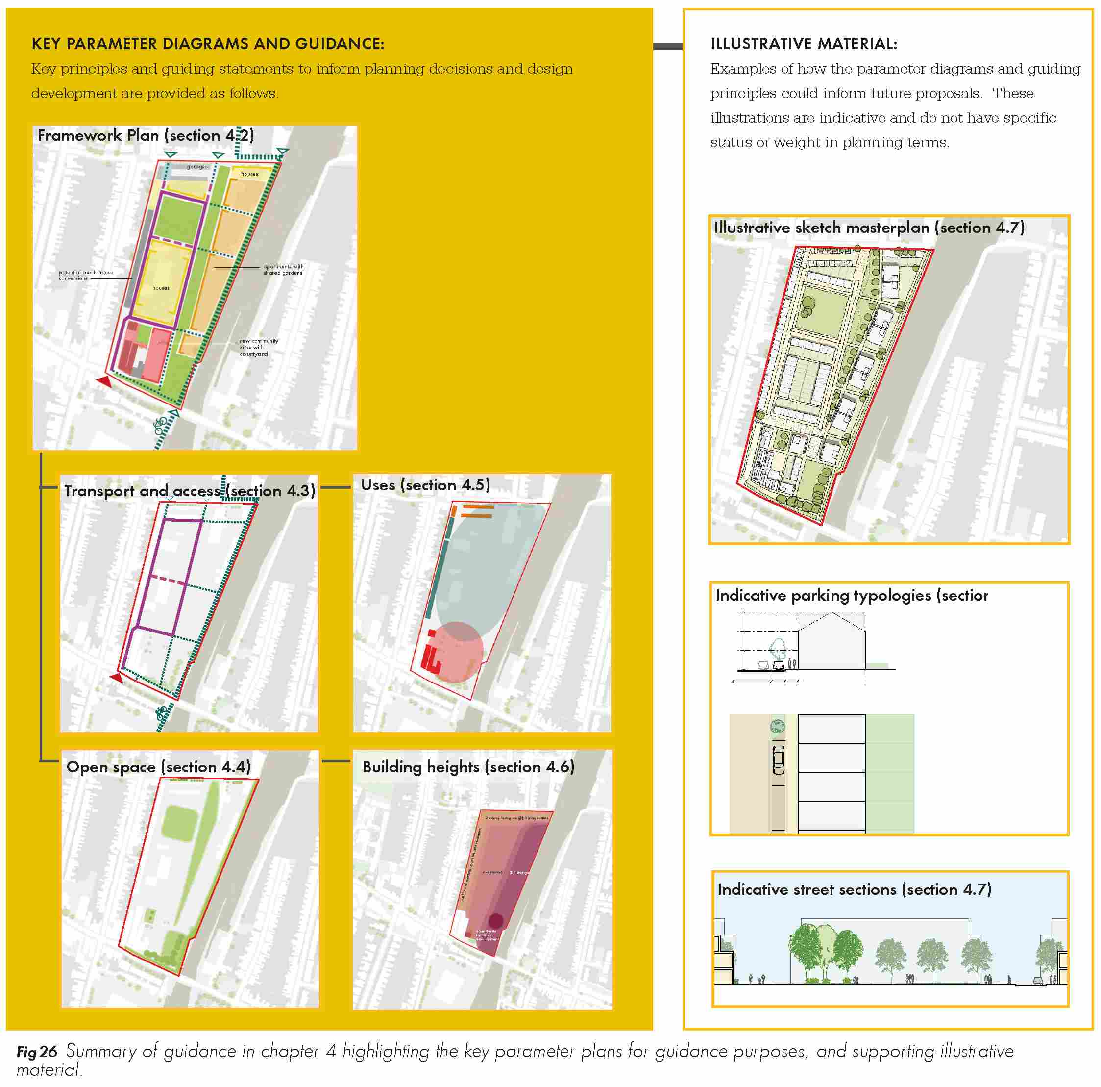
(1) 4.1.3 As well as complying with the planning and design guidance in this SPD, any future planning applications should comply with the policies in the Cambridge Local Plan (2006) and its replacement currently the subject of an examination led by a government inspector. This chapter is structured under the following headings:
- Site layout
- Transport and access
- Open space
- Uses
- Building heights
- Character and form
- Environmental considerations and sustainability
- Planning obligations
4.2 SITE LAYOUT
(1) 4.2.1 The site layout (see figure 27) assumes the retention of the existing access route running north-south through the site from the Depot entrance at Mill Road towards the garages to the north. This alignment is informed by the retention of the Grade II Listed Building and undesignated Gateway building at the entrance to the site.
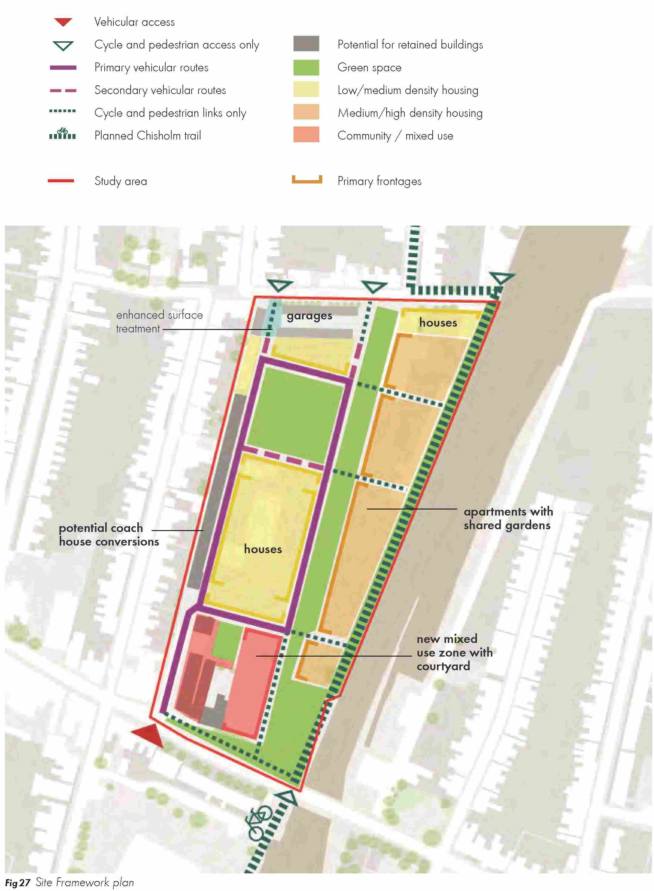
(1) 4.2.2 The primary route will be complemented by a new central route situated broadly in parallel and to the east. The precise position of the new route will be determined by detailed design work including the dimension of the development block / open spaces between the primary routes.
4.2.3 East-west linkages should be established to connect the primary north-south routes. These will be informed by the precise position of residential frontage and open spaces.
4.2.4 Tertiary pedestrian and cycle links will complement the dominant north-south grain and the secondary east-west linkages. Of particular importance is the Chisholm Trail which coincides with the eastern boundary to the site adjacent to the railway.
4.2.5 Key frontages have been highlighted on the drawing. The precise location of these will evolve through the detailed design process at a planning application stage, but it is important that frontages define key streets and spaces as illustrated in the drawing.
4.2.6 Reference should also be made to the following sections on transport and access (4.3), open space (4.4) and character (4.7).
4.3 TRANSPORT AND ACCESS
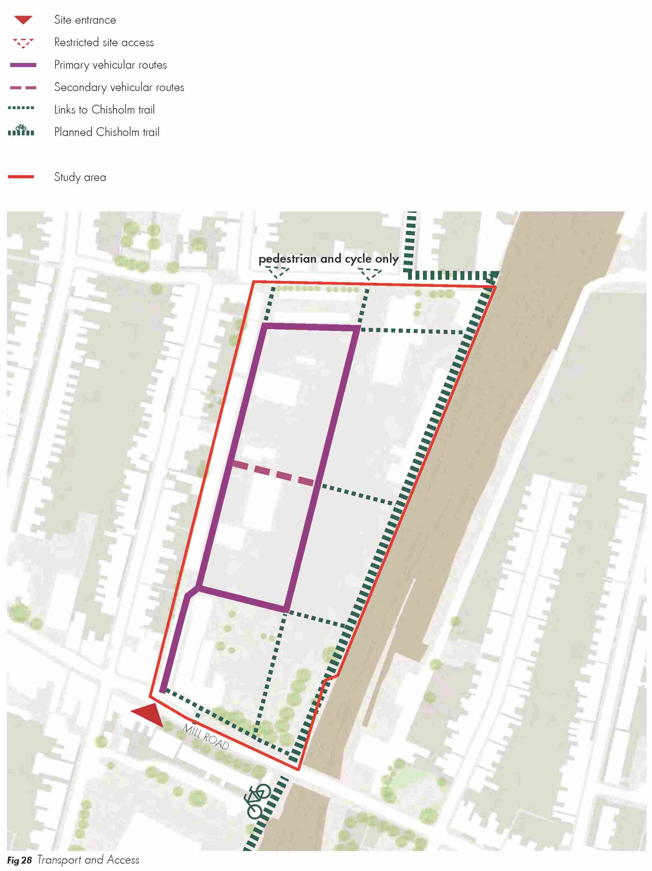
(1) 4.3.1 The overall approach to transport and access is summarised on Figure 28.
(5) Pedestrian and cycle connectivity
4.3.2 Proposals should make full provision for the delivery of the Chisholm Trail cycle route which will enter the site from the south via the arch formed by the railway bridge at the southern boundary of the site. The route should be incorporated within the demise of Depot site ownership, running parallel to the railway line and reconnecting to the on-street network at Hooper Street. The Chisholm Trail proposals (see figure 28) assume a parallel north-south route to the east of the railway line. Proposals should demonstrate how wider cycling patterns have been considered to ensure an integrated approach in the local area.
(1) 4.3.3 For the purposes of the SPD, it is assumed that the Chisholm Trail would be accommodated as an off-road, segregated route with a minimum of 6m width, or otherwise identified in guidance on the Chisholm Trail. Opportunities to incorporate other objectives such as biodiversity mitigation, drainage or landscape planting should be pursued.
(3) 4.3.4 Proposals will be required to demonstrate an appropriate cycling strategy in terms of the immediate site, and wider cycling journeys which interface with the site. Particular attention will be required to illustrate how cyclists heading east from the City Centre join the Chisholm Trail. There is a natural desire line for cyclists to enter the site of the Mill Road Depot junction and join the Chisholm Trail (heading north of south) via the path in front of the language school. This movement requires careful design review in the context of potential junction enhancements (see below) to ensure a safe, formalised means of access. Although northward movements will be possible, the County Council might seek to encourage principal strategic cycle journeys via the branch of the Chisholm Trail to the east of the railway bridge.
(1) 4.3.5 Sightlines between local cycle routes and the main Chisholm Trail will need to be reviewed to encourage safe access.
4.3.6 Local cycle and pedestrian only connections will be encouraged on-site. Pedestrian and cycle connections will also be accommodated on primary and secondary routes. Cycle, pedestrian and emergency only movements will be accommodated at the points of connection to Hooper Street.
(2) Vehicle access, routes and hierarchy
4.3.7 In line with the site allocation, vehicle access to the site should be from the Depot entrance on Mill Road.
(2) 4.3.8 Cambridge City Council is reviewing the primary access point which will consider the junction layout in the context of traffic count analysis, a Stage 1 Road Safety Audit (RSA1), the general layout of the site and emergency access requirements. As part of this, the City Council is working closely with Cambridgeshire County Council to consider basic requirements for safe ingress and egress to the site. A more detailed junction concept and assessment will be required as part of any future planning application. As one solution, it is likely that the existing bridge ramp, pier and railing at its north-westerly corner will need to be widened out to improve sightlines when exiting the site.
(1) 4.3.9 Access to leased garages only or emergency vehicles only is likely to be provided from the northern end of the site from Hooper Street. Subject to more detailed design, this could be achieved via the existing entrance to the garages, or from a new point of entrance on alignment.
(1) 4.3.10 Any future site developer will need to demonstrate appropriate capacity at the Mill Road junction for all vehicles to/from the site in addition to required works to facilitate these movements.
4.3.11 Developers will be encouraged to incorporate a traffic calmed environment using street design and intersecting cross routes to create a natural reduction in speeds. Shared surface environments should be employed including for the retained route adjacent to the coach houses at the western edge of the site.
4.3.12 The presumption is that existing access restrictions on surrounding streets would remain.
(4) Car parking
4.3.13 Cambridge City Council’s car parking standards are expressed as maximum standards in line with national guidance and the City’s Council’s sustainability aims. The Local Plan identifies a justification for car parking provision below this maximum given the site’s close proximity to public transport, shops and services. Based on discussions to date, the aspiration is to provide low car parking provision with an additional visitor parking space of 0.25 per home (i.e. 1 visitor space for every four homes). Any parking allocation will need to be justified in future planning applications in the context of more detailed design, assessments and the exact proportion of house types.
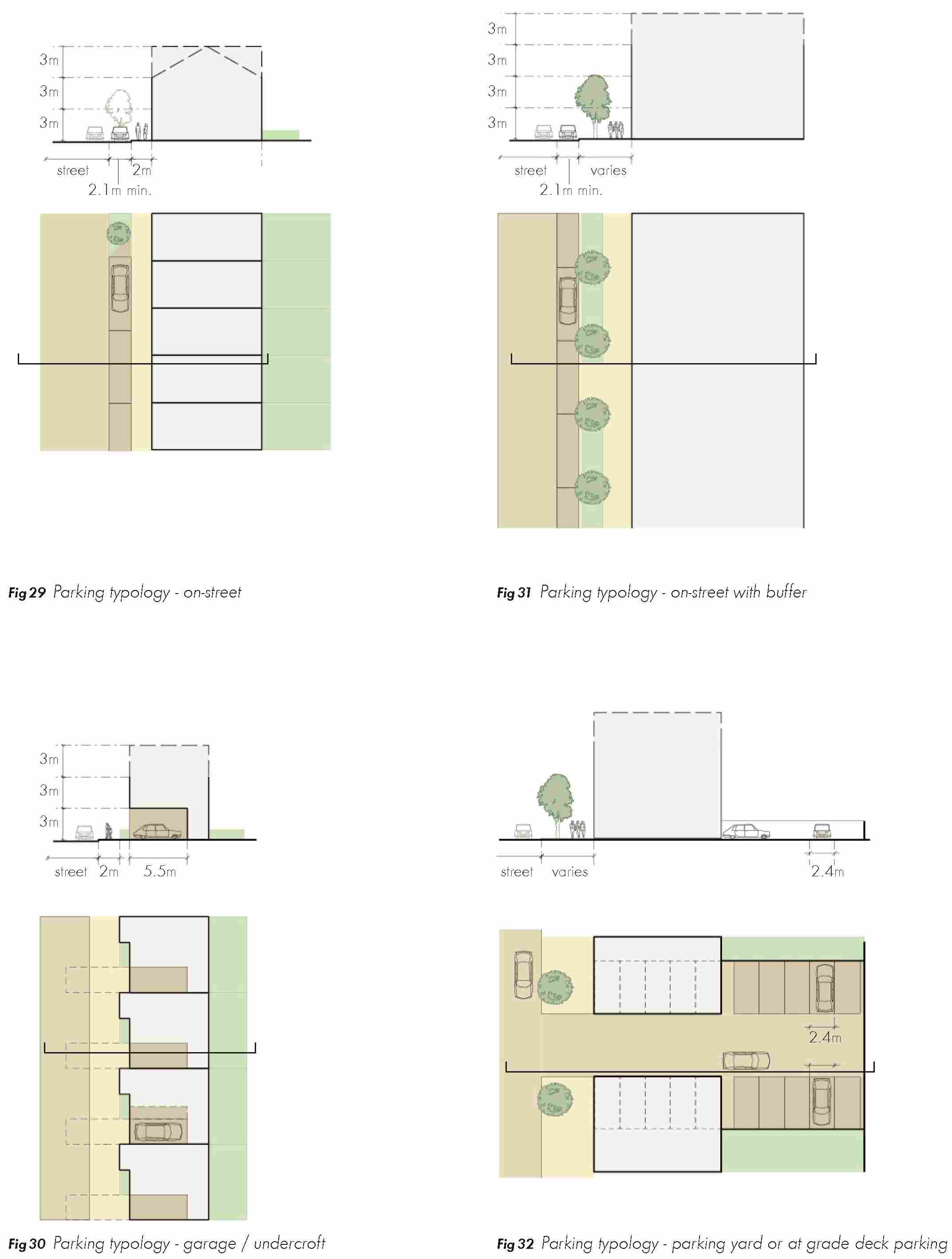
4.3.14 Car parking should be provided in a range of typologies (see figure 29 to 32), including parallel on-street bays, on-plot in integrated garages or undercroft spaces or allocated off-street parking courts / at grade "decks". The potential for the use of car clubs and electric vehicle charging points within the development as a whole should be investigated early in the development process.
(1) 4.3.15 The Council will encourage early liaison with Cambridgeshire County Council to consider the wider strategy for the adoption of streets and car parking management including potential for a pay and display regime.
Cycle parking
4.3.16 Safe and secure cycle parking should be provided and should accord with Cambridge City Council’s policy requirements. Cycle parking should be considered early in the design process with an emphasis on Sheffield stands or within garages where appropriate.
4.4 OPEN SPACE
(3) 4.4.1 A significant proportion of the Mill Road Depot site should be allocated to open space as set out in figure 33. Through consultation, stakeholders identified an aspiration to create a balanced approach to open space which combines the needs of the wider Mill Road community, the existing neighbourhood to the north and new residents on the site.
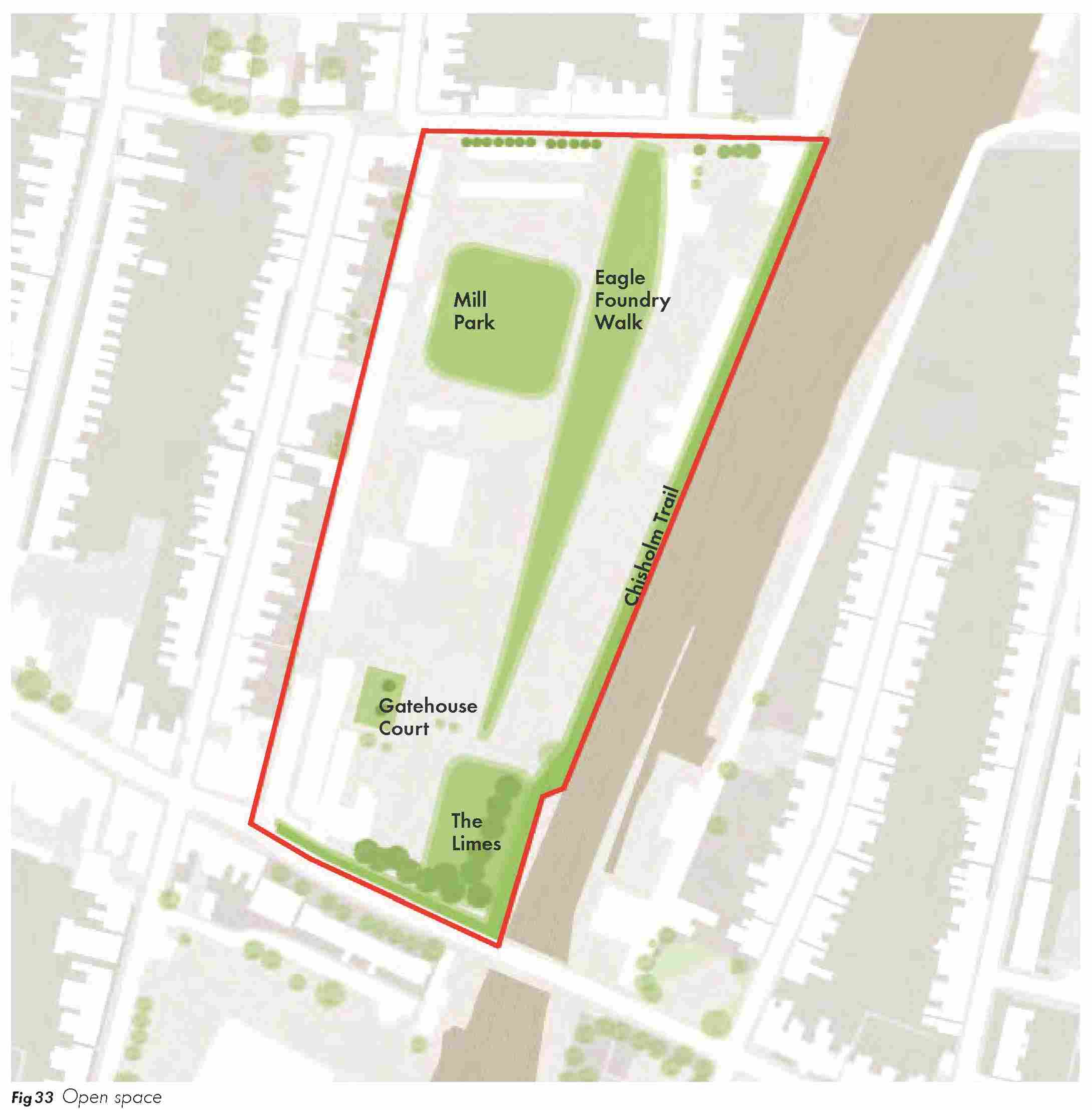
(2) 4.4.2 In this context, the open space strategy focused on two primary spaces; a new space adjacent to Mill Road bordered by the Chisholm Trail as it enters the site and an open space to the north in closer proximity to Hooper Street. This spatial strategy supports initial guidance / advice relating to sustainable urban drainage (SUDS) which is likely to necessitate a minimum space allocation for on-site attenuation requirements in close proximity to existing infrastructure at the north and south of the site. Further guidance is set out in section 4.8.
(2) 4.4.3 Subject to detailed design process including the delivery of the full housing allocation and adherence to the key principles and parameters in this chapter, it is anticipated that a future scheme could indicatively accommodate approximately 20% to 25% of site area as open space.
(1) Street trees
4.4.4 Existing trees are an important factor on development sites and a material consideration in the UK planning system. There are trees located on and immediately adjacent to the Depot that will need to be considered as part of any redevelopment proposals. In accordance with BS5837: 2012 Trees in relation to design, demolition and construction - Recommendations, the above and below ground tree constraints should be collated by an arboriculturalist and this information used to inform development layouts.
4.4.5 Street trees should be planted on the primary north-south streets, the Chisholm Trail and to mark the boundaries of key open spaces. Species should be selected to establish a sense of hierarchy through the streets and spaces including larger trees on key routes, junctions and spaces. Opportunities to establish early planting regimes will be encouraged alongside other key elements of site infrastructure to accelerate place-making benefits for new streets and urban spaces on the Depot site.
4.4.6 New development schemes should take a proactive approach in consulting with the Conservation team and Tree Officers to review the strategy to retention and selective removal / replacement. For example, the existing mature trees at the south eastern corner of the site form a distinctive boundary to the site which might require active stewardship and management through appropriate surveys and interventions.
Open space character areas
4.4.7 As set out above, any future planning applications should set out a comprehensive open space strategy which articulates a distinct approach to formal and informal spaces across this accessible urban site. Although there is a degree of flexibility, any scheme should seek to include the following elements. Historic site plans have inspired the identification of possible names for the key spaces, but these will be subject to further discussion and review as the project moves forward.
- (2) “The Limes”: Proposals should seek to embed a new space at the south eastern corner of the site as a cornerstone of the scheme. This space will provide a flexible asset for the Mill Road area being within easy walking distance of the principal pedestrian entrance to the site and immediately adjacent to the Chisholm Trail as it enters the site from the south. This space, bounded by mature trees, will be defined as an attractive formal setting with potential for a wide range of regular, or more temporary, events which appeal to new residents and the wider neighbourhood. As noted above, some interventions might be required subject to more detailed assessment of existing tree health. Replacement species should achieve a similar scale and enclosure to this important edge. As noted in section 4.8, it is likely that this space would form part of a wider drainage strategy accommodating water storage (attenuation) for the purposes of managed discharge to the south of the site.
- “Mill Park”: Future development should also include a new more central local park with appropriate playspace and facilities to serve the new community and existing residents in the wider neighbourhood. This space has potential to include larger species trees to create an attractive focal point at the heart of the development. As set out in section 4.8, it is likely that provision for surface water attenuation will be required as part of Mill Park to accommodate discharge to the northern part of the site.
- (1) “Eagle Foundry Walk”: A linear landscape feature could be incorporated adjacent to the central north-south street, forming a generous formal edge to the more substantial apartment buildings which form a strong urban boundary adjacent to the Chisholm Trail and the railway line. The exact layout and orientation of this space in relation to the residential frontages should be resolved at a detailed design stage. For the purposes of the illustrative scheme, the apartments and associated linear space deviates from the dominant alignment of the primary north-south streets in response to the orientation of the railway line and Chisholm Trail – widening from south to north and then cutting back to form an axial connection to Ainsworth Street. This is likely to form a popular pedestrian route through the site and will also form an edge to a less formal on-street cycle connection which complements the Chisholm Trail. The space offers opportunities for street tree planting and incorporation of biodiversity measures.
- (1) Chisholm Trail: A 6m zone should be reserved at the eastern edge of the site to accommodate the segregated, off-road Chisholm Trail. This linear route will make allowance for a 2-way cycle way and a separated cycle zone alongside appropriate public realm and planting. The route could form part of a wider green infrastructure strategy with biodiversity and drainage functions. Early liaison with relevant officers at the City Council and County Council will be required to ensure integration with wider design proposals for this city-wide cycling strategy. Careful consideration of patterns of cycle and pedestrian movement across the wider Depot site will be required to mitigate potential conflicts and safety issues.
- (1) “Gatehouse courtyard”: The illustrative scheme highlights the potential for a new local square adjacent to the retained and refurbished Gatehouse building. Depending on the exact layout and mix / disposition of uses, this could have a community focus, or take on a semi- public character with connections to adjacent community uses including a nursery.
Play space
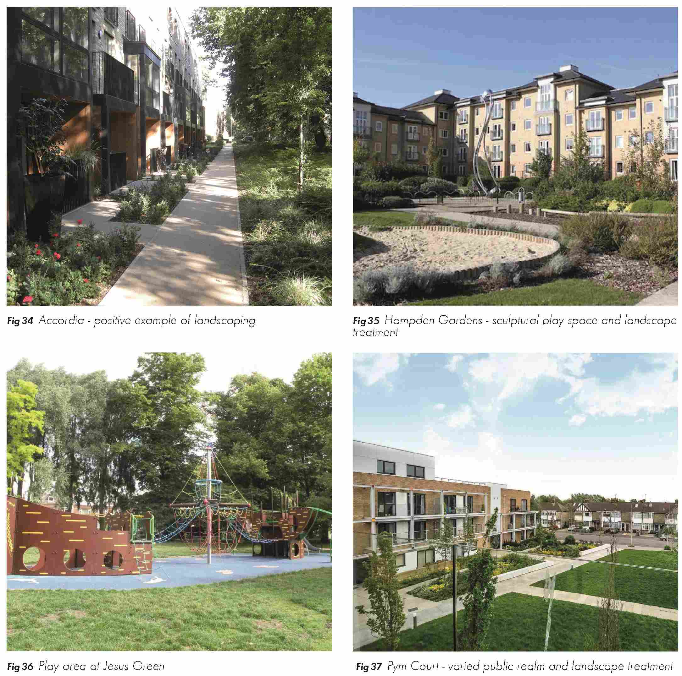
4.4.8 Children’s play space for a range of ages should be provided in the development. It is estimated that approximately 0.13ha of equipped play space / outdoor provision would be required on- site. Allotments and opportunities for communal growing could be provided on-site, depending on local demand. Examples of spaces are illustrated in figure 34 to figure 37.
Outdoor sports pitches
(1) 4.4.9 Given the relatively small size of the site and its long rectangular form, it is not appropriate to provide outdoor sports pitches on site. Commuted sums for off-site provision or improvements in lieu of on-site provision will be sought.
Shadow studies
4.4.10 All proposals for the site should use shadow studies at different times of the year to demonstrate that the public open space receives a reasonable amount of sunlight.
4.5 USES
Housing
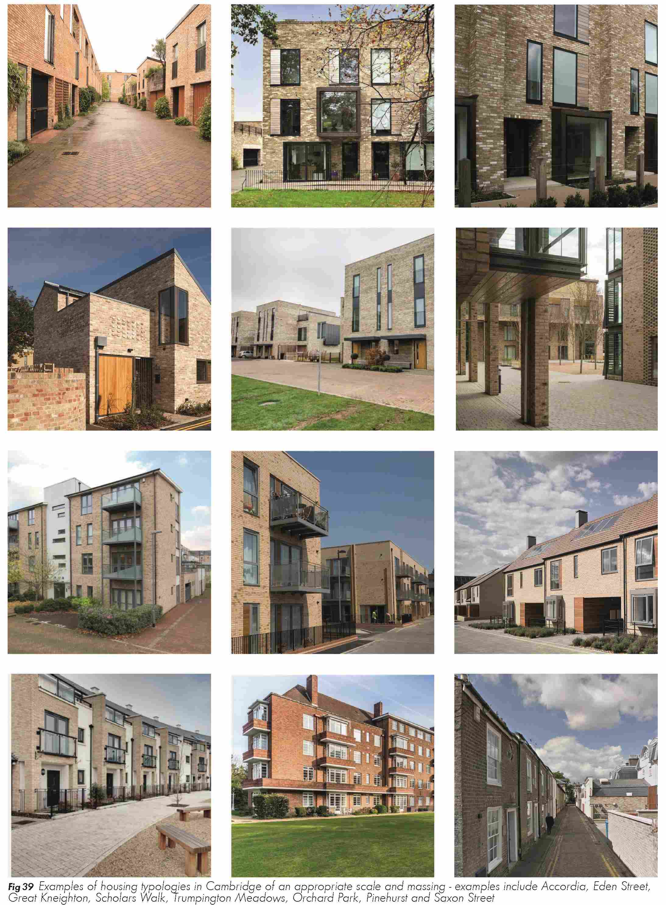
(4) 4.5.1 In line with the site allocation, the primary land use will be housing. The site has capacity for 167 homes during the Local Plan period to 2031. The indicative approach to uses is set out on figure 38.

(1) 4.5.2 The site is suitable for a range of house typologies and it is anticipated that the City Council will seek to achieve a balanced mix of housing and apartment typologies. Based on initial capacity studies, the 167 home allocation is likely to be apportioned as 50% to 60% apartments and 40% to 50% houses. The exact mix is flexible and will be informed by a consideration of housing market dynamics, approach to tenure, and disposition of open space.
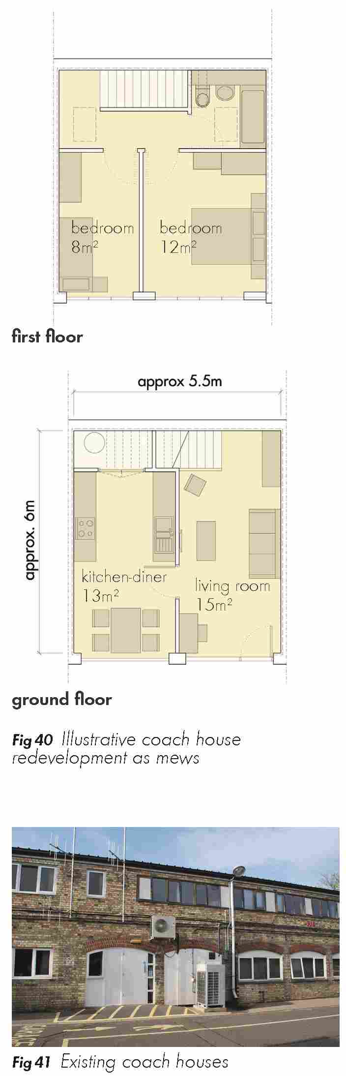
4.5.3 The images overleaf (figure 39) illustrate a range of local typologies, traditional and contemporary in form, which could be appropriate on the site. These include terraces, town houses and mews as well as apartments or mansion blocks. The precise approach will be informed by building heights as set out in section 4.6. Opportunities for bespoke refurbishment of the existing coach house blocks to 1 or 2 bedroom properties at the western boundary of the site also exist.
(4) Affordable housing
4.5.4 The policy requirement for affordable housing is a minimum of 40%. The Council is considering a spectrum of delivery models which could include a number of different formats including co-operative housing.
Community and other non-residential uses
(5) 4.5.5 Any planning application on the Depot site will need to be informed by an appropriate assessment of demand and capacity. The assessment should be in line with Policy 73: Community, sports and leisure facilities in the emerging Local Plan. Consultation on the emerging proposals for Mill Road has pointed towards a need for new community uses and this will be considered in the context of a wider review of community resources by the Council which is due for completion in Summer 2016.
(6) 4.5.6 The exact approach will be dictated through the development of a more detailed brief. The City Council will work with partners to understand the following:
- The potential for reprovision of the Women’s Resource Centre (currently occupying the building in the north-east corner of the site). It is important to consider whether co-location with other community activities is appropriate, or whether separate standalone facility is more suitable.
- The need for flexible community spaces such as a new hall or community meeting rooms will be considered. Opportunities to make connections with adjacent open space proposals should be sought.
- Demand and need for a nursery space will be explored as a potential “anchor” community use.
- Consider the aspirations of the Language School which is outside of the ownership of Cambridge City Council.
- Other acceptable non-residential uses could include a small proportion of bespoke workspace, for example, potentially arranged as live-work units as part of the refurbished coach house units.
4.6 BUILDING HEIGHTS AND TYPES
Building and housing types
4.6.1 A range of building and housing types should be provided across the site in a mixture of houses and flats. This range of typologies will help to create an integrated community, with homes suitable for a range of household types and sizes.
4.6.2 New homes should seek to optimise solar orientation and outlook, while also providing a robust street and block layout as illustrated in the site framework plan (figure 27). Dual aspect homes should be maximised and single aspect north facing homes avoided.
Click here for Fig 27
(1) 4.6.3 New homes should generally be set-back from the street, with small front gardens or privacy strips. Where possible, ground floor properties should have rear gardens, or patios and flats should have a balcony or terrace.
4.6.4 The level of parking provision will influence the mix of house types. For example, a high proportion of garages could reduce the proportion of houses, and require an uplift in apartments to meet the 167 unit target in the Local Plan allocation.
(3) 4.6.5 Opportunities exist to refurbish the existing coach house style block (see figure 41) at the western boundary of the site. This building could divide into a range of bespoke, small 1-2 bed homes with a “mews” character (see figure 40).
Building heights
4.6.6 A range of building heights should be provided across the site to create visual interest and character (see figure 42). It is vital that detailed proposals respond to the wider context established in the Mill Road conservation area. The key characteristics are set out in chapter 2.
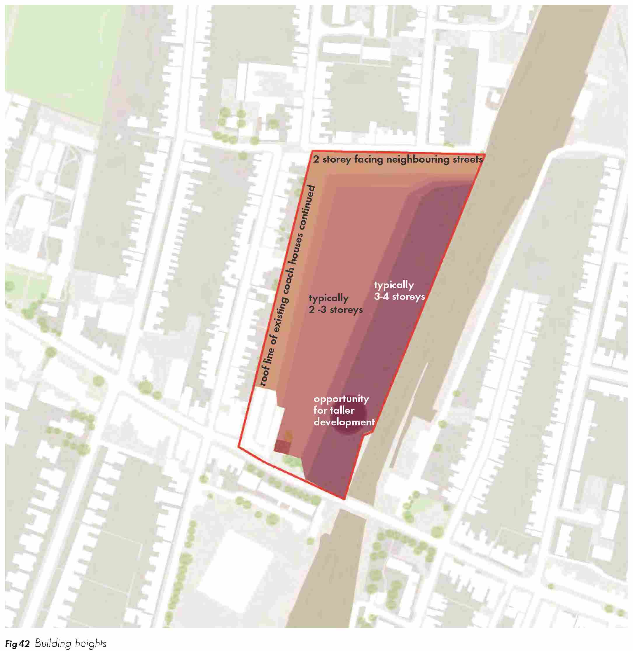
(7) 4.6.7 In broad terms, typical building heights are likely to follow a distinct east-west pattern across the site. The westerly line of building frontages, potentially involving the retained coach house- style buildings, proposed for refurbishment form a tight two storey edge at the western boundary of the site adjacent to private gardens to the rear of properties on Kingston Street. Buildings in the centre of the site will typically involve 2-3 storeys depending on the exact house types proposed. At the eastern edge of the site, it is proposed that the apartment buildings increase up to 4 storeys. Facades of any apartment building will need to be broken down to avoid the appearance of a long, horizontal edge to the railway line. A taller buildings, e.g. maximum of 5 storeys, could be appropriate at the south eastern edge of the site.
4.6.8 In general, proposals will be expected to incorporate architectural modulation and variety to generate a varied roofscape and positive streetscape / townscape character. This could be achieved through variations in massing along the street and within blocks, and innovative use of roof space for accommodation where appropriate.
(2) Heritage
4.6.9 Any planning application will be required to submit a townscape assessment and heritage statement in support of proposals. These assessments should demonstrate a thorough understanding of local context and key views. An initial appraisal of the 4 storey apartment buildings has been undertaken. Although few buildings in the conservation area reach four storeys it is considered that this scale is likely to be appropriate for the following reasons:
- Aside from the Grade II listed building and Gatehouse building, the Depot site does not make a positive contribution to the character and setting of the conservation area. It has major potential for change, and it is vital to set out a positive context for investment.
- The proposed apartment blocks are situated at the edge of the conservation area and benefit from significant separation from existing streets and views at Kingston Street to the west (by virtue of the geographical separation and the likely screening effect of existing / proposed 2/3 storey properties). To the east, views from Great Eastern Street and Mill Road are mitigated by the horizontal distance associated with the railway, the raised road level of the bridge and the natural screening effect of the existing mature trees and planting off Mill Road.
- The Council will seek to ensure that proposals are of the highest design quality and properly broken down to avoid long, horizontal facades.
Boundaries
4.6.10 All new buildings should respect the amenity of surrounding existing properties and maintain a reasonable back-to-back distance between directly facing windows of habitable rooms in existing adjacent properties. Existing vegetation within the boundary should be retained where possible.
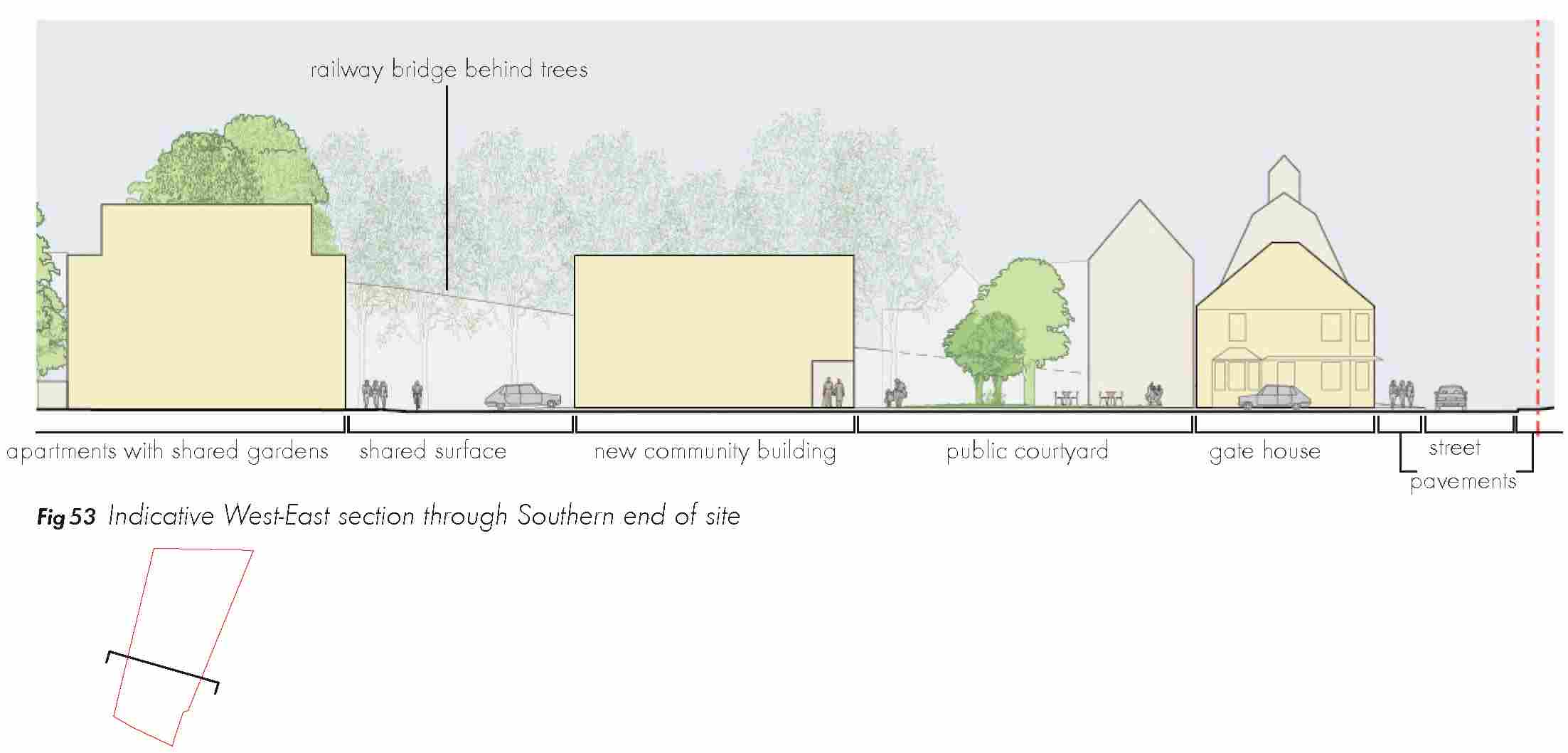
4.7 CHARACTER AND FORM
Layout
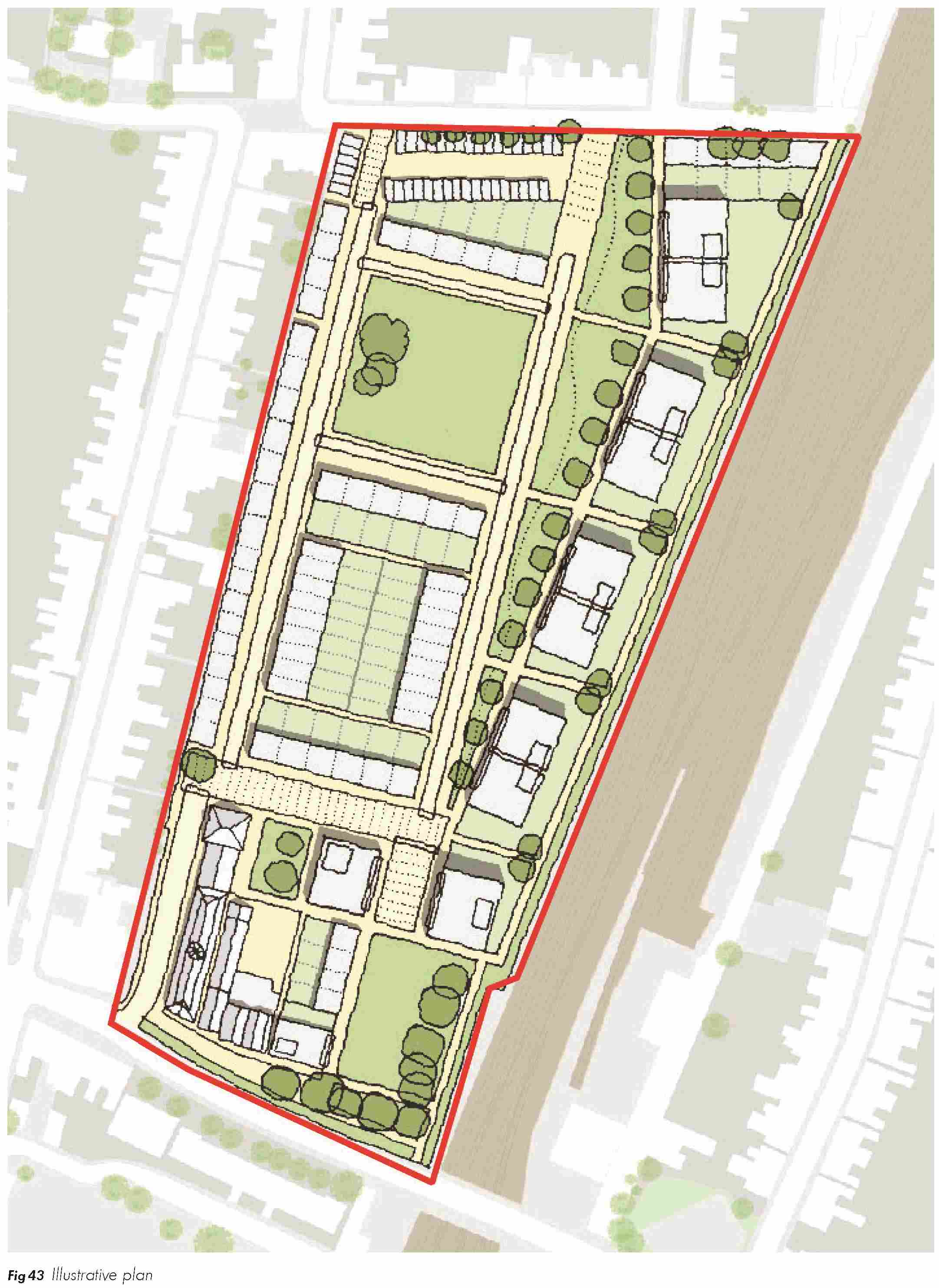
(1) 4.7.1 Section 4.2 provides an overview of the key principles in terms of site layout which is summarised in figure 6. The adjacent drawing (figure 43) provides an indicative illustration of the proposed approach. This illustrative masterplan does not have planning status for the purposes of the assessment of future applications, but provides a helpful illustration of how a scheme could come forward in response to the various parameters and supporting guidance in this document.
(1) 4.7.2 Existing streets and blocks should respond to the surrounding context as described in the Conservation Area Appraisal. A dominant north-south street pattern is suggested alongside more secondary east-west links. The street grain and approach to massing will play a key role in establishing a framework which responds to the terraced character and form that exists in streets in the surrounding conservation area.
4.7.3 Buildings should be oriented to overlook streets and public spaces, with layouts following the principles identified in best practice guidance such as Secure by Design.
(5) Long-term phasing
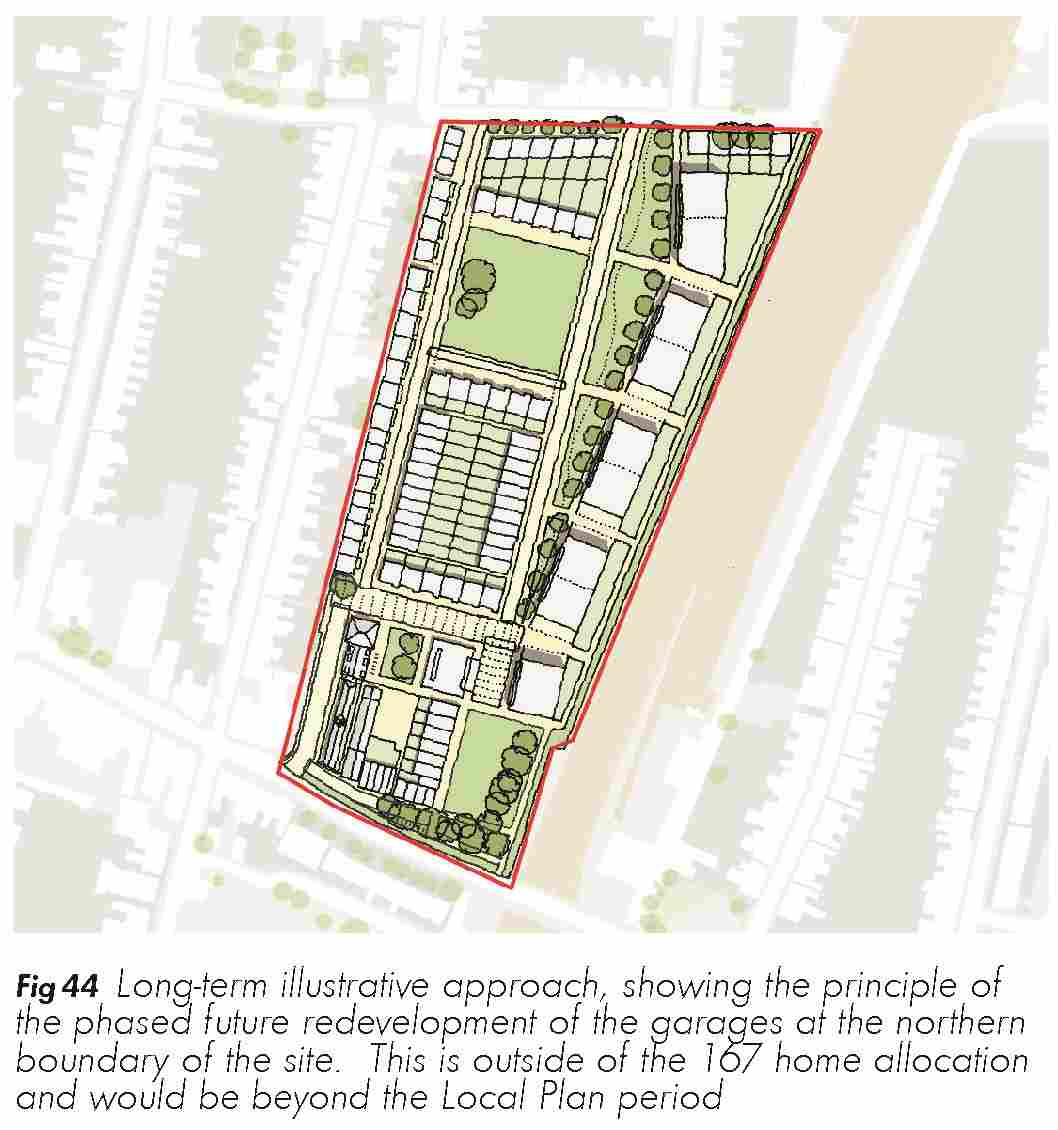
4.7.4 As illustrated on figure 44, the illustrative approach does not preclude the phased redevelopment of the existing garage blocks at the north-west corner of the site. Early work indicates that the 167 home target can be accommodated without redeveloping the garages. Subject to the expiration of existing long leaseholds, it would be possible to develop this parcel as a small collection of houses to address Hooper Street in a later phase beyond the plan period.
(2) Indicative street typologies
4.7.5 Buildings should be oriented to overlook streets and public spaces, with layouts following the principles identified in Secure by Design.
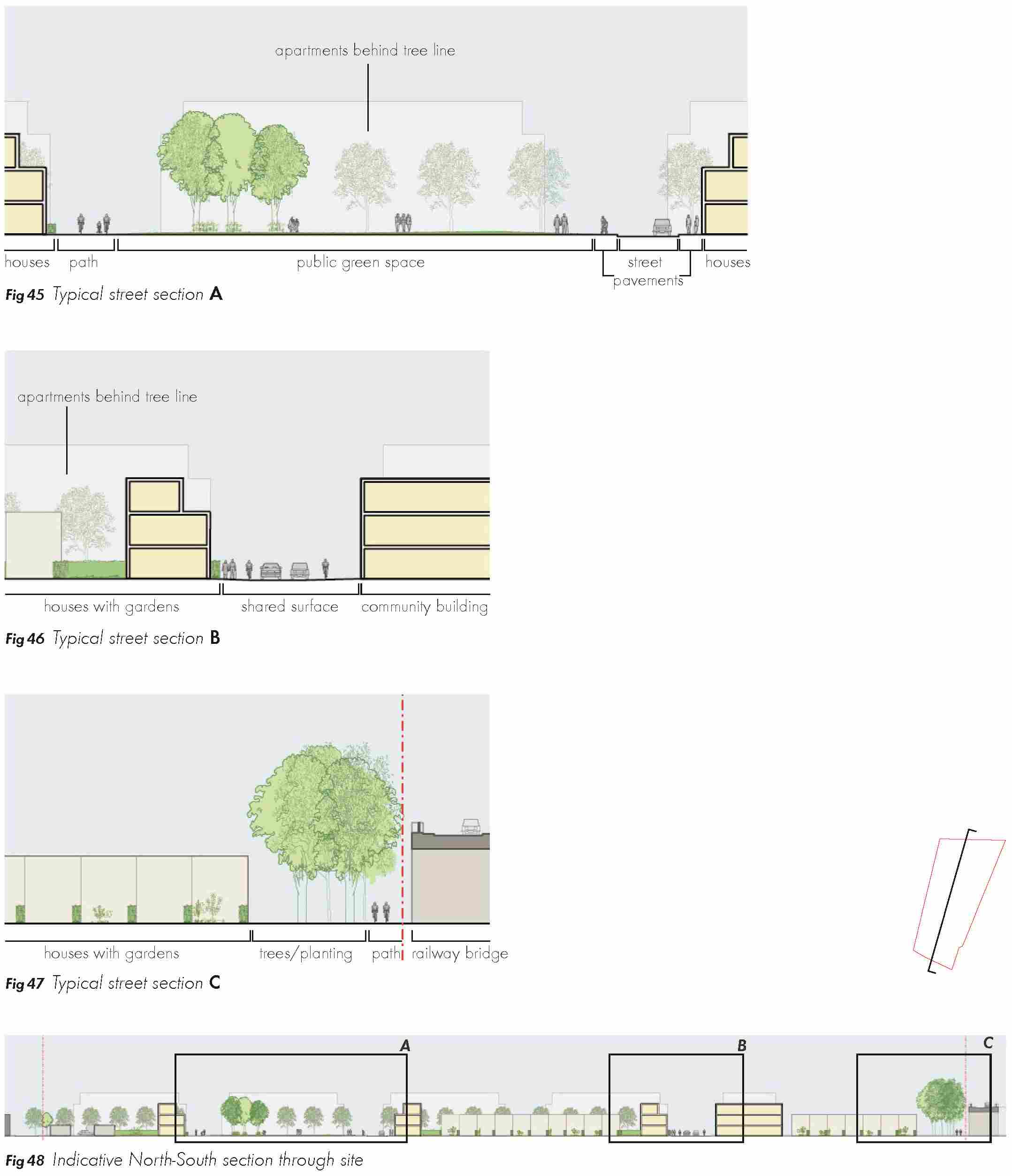
(1) 4.7.6 Variety should be encouraged through careful design of street types with a clear distinction between public and private space and a hierarchy of street widths.
(1) 4.7.7 The following street types (figures 45 to 48 and 49 to 53 overleaf) illustrate indicative street typologies that could be developed at a planning application stage.

(2) Character
4.7.8 Proposals should respond to local townscape and demonstrate a positive and appropriate response to key design features including street elevations, roofscape, materials, massing and building corners. Opportunities for contemporary design solutions which consider to traditional local styles and detailing should be incorporated as appropriate.
4.7.9 Buildings with a larger form such as the apartments could draw inspiration from the scale and materiality of the historic industrial buildings in the wider Mill Road Conservation Area or indeed, some of the former buildings on the Depot site.
4.8 ENVIRONMENTAL CONSIDERATIONS AND SUSTAINABILITY
Site-wide sustainability
(1) 4.8.1 Creating a sustainable development should be a priority underpinning the redevelopment of the Mill Road Depot site. A site wide approach should be employed to address environmental, social and economic issues. Development should comply with the Cambridge Sustainable Design and Construction SPD and propose strategies for the following relevant issues:
- Health and well-being of future residents
- Energy efficiency of new buildings
- Design for climate change
- Water use
- Flood mitigation – SUDs
- Use of materials and resources
- Waste and recycling
- Employment opportunities
- Pollution
- Transport and mobility
(1) 4.8.2 Specific strategies that could be considered for the site include:
- Mitigation of overheating in flats and taking measures to improve internal thermal comfort.
- Water sensitive urban design such as sustainable drainage features like swales, rain gardens, ponds and rills could be designed into the open space and landscape.
(1) 4.8.3 The Local Plan allocation made reference to the provision of a district energy centre. More recent work has indicated that this might not be technically suitable for the site. A combination of passive design solutions and building design solutions should form the basis of site energy strategies for future schemes.
Surface water drainage
4.8.4 Future proposals should consider the surface water drainage strategy at an early point in the design process. Initial work suggests that opportunities for storage / attenuation space should be provided as part of open spaces. These would be located close to existing discharge locations at the northern and southern parts of the site.
(2) 4.8.5 Above ground multi-functional storage could play an important role, together with a combination of sustainable drainage source control features such as rain gardens, permeable paving, swales, rills and green/brown roofs. Increased source control employed would mean that less underground storage will be required. On plot storage could provide around 5-10 cubic meters of storage per property if a parking space is provided.
4.8.6 Infiltration is the preferred method of surface water disposal and should be explored through detailed site investigations during the design development of the site; however soil types and the potential presence of contamination will possibly limit its use.
Foul drainage
4.8.7 Foul drainage has similar discharge locations, both at the south and north of the site.
4.8.8 A split between north and south would be appropriate and although it is likely that capacity would be available in both of these, a pre-development enquiry should be made to Anglian Water to determine capacities and allowable discharge rates.
Remediation
4.8.9 Elevated concentrations of various contaminants have been identified associated with made ground across the site, which would not be suitable for use within proposed domestic garden or landscaped areas. More localised contamination was identified within the northern part of the site, especially surrounding the Underground fuel Storage Tanks (USTs).
4.8.10 Impacts to soil and groundwater from fuels were identified within this area which will require further assessment.
(1) Ecology
4.8.11 There are likely to be opportunities to enhance the ecology and biodiversity of the site. Initiatives should be developed in the context of wider plans for improvements to ecology and biodiversity.
(1) 4.8.12 Initiatives that could be considered are:
- Tree and other planting where appropriate (see section 4.3 above).
- Water resources in association with SUDs and landscape features where possible
- Nesting opportunities for a variety of bird and bat species
- Habitats for insects
4.8.13 Flat and low pitched roofs could provide an opportunity to improve the ecology of the site and contribute to the general increase in biodiversity. Both green and brown roofs with local species of flora might be desirable including roof allotments. The installation of photovoltaics over green roofs is also possible as the shade will add variety to the environmental conditions.
4.8.14 Opportunities for the creation of green walls comprising climbing plants could be explored in north and east facing walls to provide nectar sources for invertebrates and cover and night roosting sites for birds. Initiatives that link the provision of ecological enhancements with the public art strategy could also be explored.
4.8.15 A Phase 1 habitat and protected species survey should be undertaken to establish which habitats and species are likely to occur. Particular focus should be on bat roost potential of any of the existing trees and buildings and invasive non-native species. This report would recommend if any further survey effort is required. BS42020 should be followed.
4.8.16 The sites should be viewed in the wider context to see how ecological connectivity between surrounding gardens, the railway line and new on site habitats may be enhanced during the master planning process. This should include detail such as gaps in garden fences to provide access for hedgehogs.
4.8.17 The SUDs design guide principles should be promoted to encourage the use of green, brown, biodiverse roofs, swales and attenuation ponds with ecological and recreational value.
(1) 4.8.18 Open Spaces and gardens should include native and non-native species trees, shrubs and herbaceous plants to provide a wide range of nesting, roosting and foraging opportunities throughout the year. There is potential to engage new residents with information packs on wildlife gardening principles.
4.8.19 As many units as practically possible, depending on scale, should have at least one integral bird or bat box for a range of species. Romsey retains a good Swift population that should be relatively easy to encourage to adopt new nest sites within the development.
4.8.20 The new residents will be well placed to use the new Chisholm trail and existing Sustran route to the south to explore Milton Country Park, RSPB Fen Drayton, Clay Farm Green Corridor and Trumpington Meadows Country park. On site interpretation or homeowner welcome pack could promote these natural sites.
4.9 PLANNING OBLIGATIONS
(4) 4.9.1 The development is likely to result in increased demands for community infrastructure such as public open space, sports, health and community facilities and additional school and nursery places. Some of these demands will be met on site and others via commuted sums to provide new or enhanced infrastructure off site. It is also possible that in addition to the provision of the Chisholm Trail through the site, other transport improvements will be needed off site. Waste and Recycling facilities may also need to be secured. Planning Obligations via a Section 106 agreement will be needed to deliver this infrastructure. The full list and scope of these Planning Obligations will be defined through the consideration of the planning application(s).