North East Cambridge Area Action Plan Issues and Options 2019
6. Place Making
What you told us previously
We asked you about whether we should apply a design led approach to the development, and whether density should reflect the sustainability of the location, particularly near the railway station.
You told us there was support for a higher density approach, in particular around transport interchanges, but this needed to consider context, and be accompanied by open space. Tall buildings needed to consider their impact on Cambridge and the surrounding area, and there was range of views on building heights that would be appropriate to the area.
6.1 NEC has the potential to create a new City District that sustains the current Research & Development Businesses that are an essential ingredient in the 'Cambridge Phenomenon'. To make best use of the land available and to maximise the possibility of creating a self-supporting new neighbourhood, development needs to be at a density that creates the best conditions for this to happen and that creates an excellent and improved gateway to the City.
6.2 A design led approach is needed to maximise the opportunities provided by the area and to successfully integrate it into the surrounding existing residential and business areas to create a cohesive community. 'Placemaking' best defines this approach, with the AAP forming the first layer in the establishment of an overall framework to guide the successful and high quality redevelopment of the area.
Figure 6.1 Concept Plan
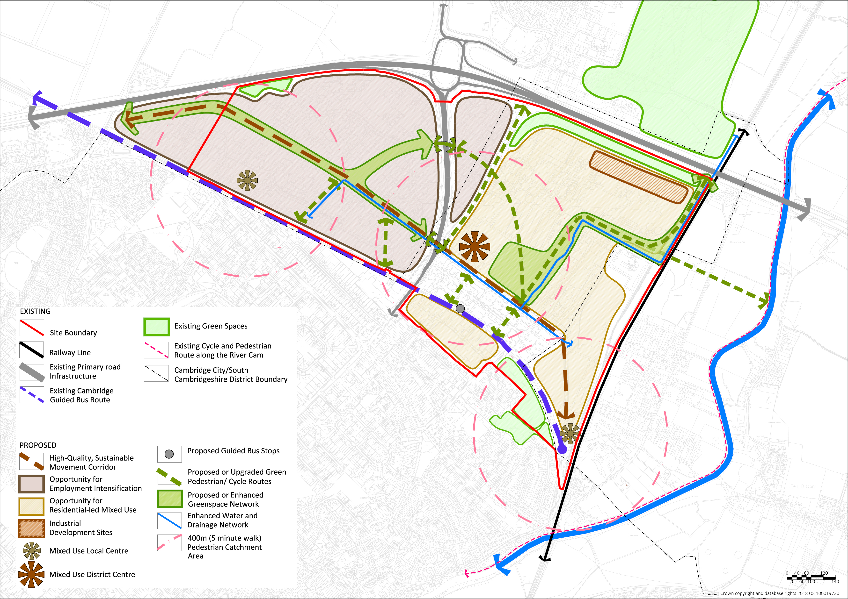
North East Cambridge Indicative Concept Plan
6.3 The NEC Indicative Concept Plan (at Figure 5.1) begins to describe the kind of place that could be created with the successful regeneration of the area. Movement and the ability to do so easily on foot, by bike or on public transport is central to making the area a well-connected place that reduces the need to travel by car. A high quality green route that supports sustainable transport modes will improve connections from the Cambridge North Station to the Cambridge Science Park, and reduce the barrier that is Milton Road.
6.4 The concept of creating a walkable neighbourhood helps to guide the number and location of the district centre and two ancillary local centres. These would provide opportunities to optimise accessibility in relation to the movement network and to create the kind of vitality and footfall needed to support a range of uses and activities that a self-sustaining new City District needs.
6.5 The area is not just about regeneration. The intensification and potential diversification of the range of uses on the Cambridge Science Park creates a genuine opportunity to bring additional businesses to the area and strengthen the Cambridge Phenomenon. Development in areas to the east of Milton Road will be predominately residential led with land allocated to support the relocation of existing industrial sites.
6.6 Green infrastructure capitalises on the network of existing trees and landscape but also extends this to create an overall framework to improve biodiversity and linkages to the wider countryside. Embedded into this framework will be the water management network that improves the First Drain and adds richness to the landscape. A new green space at a district scale will enrich the heart of this new place and provide the kind of multifunctional space that is so typical of Cambridge and central to public life.
6.7 Questions elsewhere in this chapter ask for your views on each of the individual elements shown on the indicative concept plan. However, we would like your views on the high level concept presented above.
Issue: Indicative Concept Plan
(42) Question 7: Do you support the overall approach shown in the Indicative Concept Plan? Do you have any comments or suggestions to make?
Mixed Use City District
6.8 The transport constraints and opportunities in this area mean that we need to take an innovative approach to future development. We need to deliver a place where people can live work and play locally, and travel to, from and within the site without the need for a car. The plan needs to deliver the right mix of uses where people working in the area have more opportunities to live nearby, and those living and working in the area have access to the right mix of services and facilities. This is referred to an 'internalisation', where people's day to day needs can be met within an area without having to travel. This will significantly influence the optimum land use mix to be achieved across NEC.
6.9 The existing employment areas such as Cambridge Science Park and St John's Innovation Park have played and will continue to play a pivotal role in the 'Cambridge Phenomenon'. The existing office and Research &Development buildings are home to over 100 companies from multi-national organisations to start-up companies. However, the potential to intensify and diversify these existing areas needs to be explored through the AAP to help deliver the comprehensive development of the area and make best use of the significant brownfield regeneration opportunity afforded by the relocation of the WRC. The South Cambridgeshire Local Plan already includes a policy supporting intensification of uses on the Cambridge Science Park.
6.10 The AAP area should continue to be a focus for development related to high technology and innovation. This well established and world renowned cluster will need to be carefully supported to ensure that increasing demand for employment floorspace is met over future decades.
6.11 Both the Cambridge and South Cambridgeshire Local Plans support economic growth in these industries and a number of new office buildings have recently been granted planning permission/redeveloped within Cambridge Science Park and St John's Innovation Park.
6.12 Whilst the predominant land use within Cambridge Science Park will continue to be office and research premises, there is the opportunity to introduce other land uses that would be of benefit to existing and future employees within the science park.
Issue: Creating a Mixed Use City District
(16) Question 8: Do you agree that outside of the existing business areas, the eastern part of the North East Cambridge AAP area (i.e. the area east of Milton Road) should provide a higher density mixed use residential led area with intensified employment, relocation of existing industrial uses and other supporting uses?
(14) Question 9: Should Nuffield Road Industrial Estate be redeveloped for residential mixed use development?
(8) Question 10: Do you agree that opportunities should be explored to intensify and diversify existing business areas? If so, with what sort of uses?
(25) Question 11: Are there any particular land uses that should be accommodated in the North East Cambridge area?
Creating a City District with a unique identity
6.13 This new city district needs activity and vibrancy to support the existing and establishing communities. The leisure and cultural offer to enrich lives is a key component of creating successful places and will be needed for residents, workers and visitors alike. Embedding creativity and culture into the scheme is a vital aspect to the success of NEC as a new city district with its own identity. A leisure and culture strategy along with a public art strategy will be needed early in the process to support the overall masterplanning and decision making for the regeneration of NEC.
Issue: District Identity
(21) Question 12: What uses or activities should be included within the North East Cambridge AAP area which will create a district of culture, creativity and interest that will help create a successful community where people will choose to live and work and play?
|
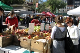
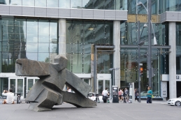
Community events and public art can be both temporary and permanent |
|
|
|
Temporary open air cinema Leicester, UK (Image source: Ian Davis/Leicester City Council) |
|
Temporary market Union Square, NYC (Image source: Image reproduced under Creative Commons License) |
|
|
|
Public art NYC |

Creating a Healthy Community
6.14 Cambridgeshire County Council has produced a Housing Developments and the Built Environment Joint Strategic Needs Assessment, which emphasises the relationship between planning and health and wellbeing of new communities. The draft AAP will need to include health related policies. A range of issues addressed in this issues and options report would contribute to making the NEC a healthy and safe place.
6.15 Recently the new town of Northstowe has been part of the NHS Healthy Towns Initiative. This considered how health, and the delivery of healthy communities, could be a key driver in the planning and design process for a new community. It provided an opportunity to explore innovation and best practice. The principles it explored included promoting inclusive communities, good access to health services, walkable neighbourhoods, high quality public transport and cycling links, and opportunities for physical activity. There are opportunities to apply similar principles in North East Cambridge.
Issue: Creating a healthy community
(19) Question 13: Should the AAP require developments in the North East Cambridge AAP area to apply Healthy Towns principles?
Cambridge Regional College
6.16 As an innovation district, NEC needs to capitalise on great links to education facilities in the area to improve links to businesses. Cambridge Regional College (CRC) is a major further and higher education facility with a catchment which includes Cambridgeshire, Essex, Hertfordshire and Suffolk. The existing CRC site supports 3,000 full-time further and higher education students. Due to its close proximity to the NEC area and the role that the college plays within the immediate and wider area we need to consider how the two can function together and support each other.
Issue: Cambridge Regional College
(8) Question 14: How should the AAP recognise and make best use of the existing and potential new links between the AAP area and the CRC?
Building Heights and Skyline
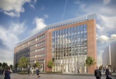
6.17 NEC provides an excellent opportunity to create a new mixed use city district with its own unique character. With this in mind, as well as the recent additions of Cambridge North railway station and the Guided Busway that create the potential to optimise proximity to this infrastructure, there are opportunities for development to be at a scale and height that would usually reflect a city centre location, and this brownfield site on the edge of Cambridge provides opportunities that may not be available in the historic city centre. Nevertheless, in order to create a city district of architectural interest, development at NEC would be expected to provide a range of building heights across the site and deliver sensitively designed and well-articulated built form along with meaningful open spaces, trees and other green infrastructure. As a city edge location, development will also need to maintain and enhance the overall character and qualities of the skyline, including demonstrating how it has taken account of the prevailing context and more distant views.
6.18 It is critical that NEC is of the highest design quality and the AAP will set out design principles which relate specifically to the area. This would require further policy guidance to establish a clear framework for proposals in relation to layout, scale, height, massing and the relationship between buildings and streets. The guidance should provide a clear steer which reduces uncertainty and supports consistency with the overall vision and will be informed by evidence such as the Landscape Character and Visual Impact Appraisal.
6.19 In recent years the scale of development in the AAP area has started to change with the development of the Bradfield Centre on the Cambridge Science Park and the currently unimplemented planning permission for an 8 storey office building adjacent to Cambridge North railway storey (overall maximum height including plant is circa 30 metres). Many of the existing Science Park buildings are equivalent to 5-6 residential storeys.
6.20 In order to use land effectively and efficiently, development can be at a scale that is greater in terms of height and density than its immediate surrounding context to the south of the AAP area. Clusters of taller buildings around areas of high accessibility including district and local centres and transport stops could form part of the design of this new city district, with heights and massing carefully modelled to create varied and well-articulated forms appropriate to their location within the area, including being sensitive to surrounding context. Appropriate building heights, including the consideration of taller buildings, will be informed by the findings of the evidence base studies, including Landscape and Visual Impact Appraisal, Transport Study and alongside the Urban Design response to be taken forward in the draft AAP.
|
Precedent examples of tall buildings |
|
|
|
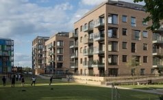
3 to 10 storey residential development, Aylesbury Estate, London (Image source: Levitt Bernstein Architects) |
|
|
Consented office development (Ground floor plus 6) Aylesbury Estate, London (Image source: Levitt Bernstein Architects) |
|
|
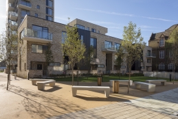
Residential development CB1 ‘Ceres’ (Ground floor plus 5) Cambridge (Image Source: Pollard Thomas Edwards) |
Issue: Building Heights and Skyline
(32) Question 15: Should clusters of taller buildings around areas of high accessibility including district and local centres and transport stops form part of the design-led approach to this new city district?
Local movement and connectivity
6.21 Chapter 6 of this Issues & Options report considers the wider transport implications of the regeneration of NEC. At the local level, and intrinsically linked into the placemaking led approach, are decisions around movement and connectivity within the NEC area and linkages to the surrounding area. Improvements could establish new or upgraded walking, cycling and public transport connections between Cambridge North Station, the employment areas, Cambridge Regional College, and the surrounding neighbourhoods. In addition, leisure and active routes for walking cycling and equestrians which integrate with the wider countryside beyond are crucial in achieving a shift away from private car dependent forms of development, and towards a 'walkable district'. This would allow and encourage easy change between sustainable modes and influences the way that the place will work and meet the needs of those that live and work in the area.
6.22 A number of projects would help to establish improved connectivity to NEC, including the Chisholm Trail and Waterbeach Greenways. These would be delivered as part of separate projects and would connect Cambridge North Station with Cambridge Station, Cambridge Biomedical Campus and Addenbrooke's Hospital. In addition, they provide linkages to Northstowe and the planned new town north of Waterbeach.
6.23 The development of the NEC presents a great opportunity to create a new network of streets and open spaces that will support and improve movement of people throughout the area. To achieve this, new streets, open spaces and green routes will form a comprehensive urban structure and be at the centre of the design of this new city district.
6.24 There are a number of potential options that can achieve this, which could include all or a combination of the options below.
Issue: Local movement and connectivity
(34) Question 16: Should the AAP include any or a combination of the options below to improve pedestrian and cycling connectivity through the site and to the surrounding area?
A – Create a strong east-west axis to unite Cambridge North Station with Cambridge Science Park across Milton Road. This pedestrian and cycle corridor would be integrated into the wider green infrastructure network to create a pleasant and enjoyable route for people to travel through and around the site. The route could also allow other sustainable forms of transport to connect across Milton Road.
B – Improve north-south movement between the Cowley Road part of the site and Nuffield Road. Through the redevelopment of the Nuffield Road area of NEC, it will be important that new and existing residents have convenient and safe pedestrian and cycle access to the services and facilities that will be provided as part of the wider North East Cambridge area proposals.
C – Upgrade connections to Milton Country Park by both foot and cycle. This would include improving access to the Jane Coston Bridge over the A14, the Waterbeach Greenway project including a new access under the A14 (see Transport Chapter), as well as the existing underpass along the river towpath.
D – Provide another Cambridge Guided Bus stop to serve a new District Centre located to the east side of Milton Road.
E – Increase ease of movement across the sites by opening up opportunities to walk and cycle through areas where this is currently difficult, for example Cambridge Business Park and the Cambridge Science Park improving access to the Kings Hedges and East Chesterton areas as well as the City beyond.
Crossing the railway line
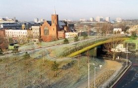
6.25 Providing a cycling and pedestrian bridge over the railway could have benefits to NEC users to access the river corridor and its recreation opportunities. It would also help neighbouring communities to access the new services, facilities and employment that will be delivered in this area.
Issue: Crossing the railway line
(53) Question 17: Should we explore delivery of a cycling and pedestrian bridge over the railway line to link into the River Cam towpath?
Milton Road connectivity
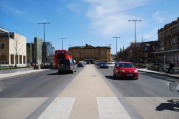
6.26 There is an opportunity to reduce the dominance of Milton Road to create a better environment and enhance the area as a gateway to Cambridge. This could also link the Cambridge Science Park and the area to the east of Milton Road better and create an improved environment for interaction between the two.
6.27 Milton Road currently acts as a barrier to pedestrian and cycling movement across the area, and in particular between the Cambridge North Station and the Cambridge Science Park. If we are to make the area more attractive for access by means other than the car, and to create a well-connected and coherent city district, significant improvements will be required.
6.28 There are a range of ways this could be done, from bridging over the road to changing the nature of the road itself. The ambition is to create a better environment and enhance the approach to the City of Cambridge and the gateway to the Innovation/High-Tech cluster.
Issue: Milton Road connectivity
(32) Question 18: Which of the following options would best improve connectivity across Milton Road between Cambridge North Station and Cambridge Science Park?
A - One or more new 'green bridges' for pedestrians and cycles could be provided over Milton Road. The bridges could form part of the proposed green infrastructure strategy for NEC, creating a substantial green/ecological link(s) over the road.
B - Subject to viability and feasibility testing, Milton Road could be 'cut-in' or tunnelled below ground in order to create a pedestrian and cycle friendly environment at street level. This option would allow for significant improvements to the street which would be more pleasurable for people to walk and cycle through.
C - Milton Road could be significantly altered to rebalance the road in a way that reduces the dominance of the road, including rationalising (reducing) the number of junctions between the Guided Busway and the A14 as well as prioritising walking, cycling and public transport users.
D - Connectivity across Milton Road could be improved through other measures. We would welcome any other suggestions that would improve the east-west connectivity through the site.
E - Other ways of improving connections (please specify)
|
Precedent examples of improving pedestrain and cycling connectivity |
|
|
Green bridge, Mile End Park, London (Source: Tower Hamlets Council) |
Reducing the width of the carriageway and creating a more pleasant pedestrian experience, Fridesride |
|
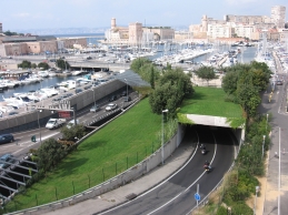
Road tunnelling and introduction of green spaces at street level Saint Laurent, Marseille (Image source: Image reproduced under Creative Commons License) |
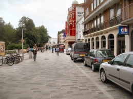
Improvements to the public realm to reduce the dominance of the road New Street, Brighton (Image source: Image reproduced under Creative Commons License) |
Development fronting Milton Road
6.29 Milton Road has the potential to form an important linking area within the wider NEC area. Currently the development to either side of the road is relatively hidden and inward facing and allows the junction and 'highway' to dominate. Regeneration of the area creates the opportunity to revisit how development on each side of Milton Road might interface with this key route. The role of Milton Road as part of the gateway to Cambridge is therefore a key consideration.
Issue: Development fronting Milton Road
(11) Question 19: Should development within the North East Cambridge area be more visible from Milton Road, and provide a high quality frontage to help create a new urban character for this area?
Managing car parking and servicing
6.30 Cambridge North Station and the Guided Busway (including the adjacent maintenance track/cycleway) have radically altered the accessibility of the area and make sustainable modes a realistic and attractive option. There is also limited scope to increase the number of motorised vehicles using Milton Road. Car parking and traffic generation are inextricably linked. Whilst some parking will be needed, there is a recognition that car parking provision will need to be below the standards set out in the Local Plans and provided in different ways. This needs to have a key impact on how the site operates in transport terms in order to reduce levels of car use and support travel by means other than the car. The level of car parking provided, and the management of both on and off-site car parking and car use, will need to be carefully considered. In placemaking terms reducing the impact of vehicles through the district, either moving or stationary, is a key aim of rebalancing spaces in favour of pedestrians and cyclists and supporting sustainable transport modes.
6.31 There is also a need to differentiate between car ownership and car use. Vehicles using the network 'off peak' are unlikely to create the same issues regarding congestion that peak time movements will bring, but seeking to minimise car use, at any time of the day, is an important consideration. However, such an understanding will be vital to managing servicing and deliveries too with consideration of last mile delivery strategies, consolidated deliveries and delivery/collection hubs required to ensure that this new place 'works' to meet the day to day needs of people living and working in the area. The use of car clubs could provide for infrequent car based trips when other more sustainable modes are not possible.
6.32 In order to address this, there will be a need to reduce car parking provision significantly as part of new development proposals and to consider whether the existing number of car parking spaces found in the employment areas across the entire NEC area could be reduced or redistributed. The latter would require further discussions with the relevant businesses and landowners but would ensure that there is a minimal net increase in the number of additional car parking spaces as a result of development and potentially allow further development within the overall proposed area-wide highway trip budget. Measures to manage on-street parking in the area and surrounding areas may also be required.
Issue: Managing car parking and servicing
(29) Question 20: Do you agree with proposals to include low levels of parking as part of creating a sustainable new city district focusing on non-car transport?
(23) Question 21a: In order to minimise the number of private motor vehicles using Milton Road, should Cambridge Science Park as well as other existing employment areas in this area have a reduction in car parking provision from current levels?
(9) 21b: Should this be extended to introduce the idea of a reduction with a more equitable distribution of car parking across both parts of the AAP area?
(16) Question 22: Should the AAP require innovative measures to address management of servicing and deliveries, such as consolidated deliveries and delivery/collection hubs?
Car and other motor vehicle storage
6.33 Radically rethinking car use patterns creates opportunities to think creatively about how and where private cars should be stored and help reduce the visual and practical impact of car parking on the area. It is referred to as car storage, as cars would not be needed for day to day use. Developments in Freiburg show how using 'car barns' on the periphery of development areas allows streets and spaces to be rebalanced in favour of walking and cycling. The NEC AAP could adopt this approach along with more conventional basement car parking to provide 'car storage' and make more efficient use of the land available. Car parking structures should be designed so that they complement their local environment, for example wrapping them in other uses and being designed to allow their future conversion to meet other needs such as for increased cycle parking or alternative uses such as commercial or residential.
|
Precedent examples of car storage and car share scheme |
|
|
|
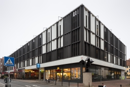
Example of car storage – a multi-storey car park located on the edge of a neighbourhood Hannover, Germany |
|
|
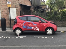
Car share scheme London (Image source: Image reproduced under Creative Commons License) |
Issue: Car and other motor vehicle storage
(19) Question 23: Should development within the North East Cambridge area use car barns for the storage of vehicles?
Green Space
6.34 The site is in close proximity to Milton Country Park and the River Cam Corridor. There will be a requirement for development in NEC to improve pedestrian and cycle connectivity to these well used spaces. As part of this strategy, a strong green infrastructure network will be introduced through the site which will connect north towards Waterbeach new town, west through the Science Park and into Cambridge Regional College, and east to the River Cam and the fenland landscape beyond (see Transport Chapter).
6.35 If NEC is to make a significant contribution to Greater Cambridge's employment and housing needs, maximising the benefits to be realised from the new rail station and Guided Busway, it will be critical that the AAP requires enhanced pedestrian and cycle connectivity to Milton Country Park and the River Cam corridor.
6.36 Green Infrastructure provision will help to structure and soften this new city district. It has a key role in providing space for sustainable drainage systems (SUDS), which will be important in this area. They also provide social spaces which support community activities and healthy activities.
6.37 There are a number of ways how this can be delivered and all would link to the proposed wider green infrastructure/biodiversity strategy.
Issue: Green Space provision
(31) Question 24: Within the North East Cambridge area green space can be provided in a number of forms including the following options. Which of the following would you support?
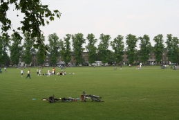
A – Green space within the site could be predominately provided through the introduction of a large multi-functional district scale green space. Taking inspiration from Parker's Piece in Cambridge, a new large space will provide flexible space that can be used throughout the year for a wide range of sport, recreation and leisure activities and include a sustainable drainage function. The sustainable drainage element would link into a system developed around the existing First Public Drain and the drainage system in the Science Park. The green space could be further supported by a number of smaller neighbourhood block scale open spaces dispersed across the site.
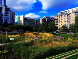
B – Green spaces within the site could be provided through a series of green spaces of a neighbourhood scale that will be distributed across the residential areas. These green spaces will also be connected to the green infrastructure network to further encourage walking and cycling. Again, these spaces will include a sustainable drainage function and link into the existing First Public Drain and the Science Park drainage system.
C – Enhanced connections and corridors within and beyond the site to improve the biodiversity and ecological value as well as capturing the essential Cambridge character of green fingers extending into urban areas. These corridors could also be focussed around the green space network and sustainable drainage and would reflect the NPPF net environmental gain requirement.
D – Green fingers to unite both sides of Milton Road and capitalise on the existing green networks.
E – Consideration of the site edges – enhancement of the existing structural edge landscape and creating new structural landscape at strategic points within and on the edge of NEC. This would also enhance the setting to the City on this important approach into the City.
F – Creation of enhanced pedestrian and cycle connectivity to Milton Country Park and the River Cam corridor
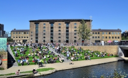
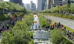
|
Precedent examples of different types of open spaces |
|
|
Multi-functional district scale open space Parker's Piece, Cambridge |
A series of green spaces of a neighbourhood scale Portland, USA (Image source: Image reproduced under Creative Commons License) |
|
Small green spaces set around residential blocks Salmon Street, Portland, USA (Image source: Image reproduced under GNU Free Documentation License) |
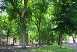
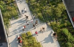
Biodiversity, ecological and movement corridors The High Line, New York City (Source: Thehighline.org) |
|
Small pockets of open space offer places to relax Granary Square, King's Cross (Image source: Image reproduced under Creative Commons License) |
Using water to add value to the public realm Cheonggyecheon, Seoul (Source: stari4ek/ Wikimedia Commons) |
|
Supporting Study |
Description |
Status |
|
A wide-ranging multi modal study commissioned by Greater Cambridge Partnership on the transport schemes needed to accommodate the major development planned at a new town north of Waterbeach, Cambridge Northern Fringe East and the Cambridge Science Park. Completed in January 2018. |
Completed |
|
|
North East Cambridge AAP Transport Assessment |
Building on the recommendations of the Ely to Cambridge Study, it will explore measures required to enable development in the area, and inform preparation of the AAP. |
To be completed |