North East Cambridge Area Action Plan Issues and Options 2019
7. Transport
What you told us previously
We asked you to comment on some key transport principles for the area, which would be to promote walking, cycling and public transport, make the area safe and permeable.
You told us you generally supported these principles, and that a comprehensive approach was needed to transport to make connections both within the site and to the surrounding area. Road access, public transport, cycling and walking were raised in individual comments.
7.1 Since we consulted in 2014 we have gathered new evidence of transport issues facing the area. The Greater Cambridge Partnership completed an Ely to Cambridge Transport Study in January 2018. The study considered the transport needs of the Ely to Cambridge corridor as a whole, including the needs of the major developments on the corridor such as the new town north of Waterbeach, and at North East Cambridge.
7.2 Currently 76% of work trips to the North East Cambridge area are made by car. This is significantly higher than many other areas in and around Cambridge, such as the Cambridge Biomedical Campus or CB1. The opening of the railway station, public transport, and cycling and walking improvements means there is a real opportunity to improve this situation.
7.3 By finding ways to make this area more accessible and attractive to travel to by other means, there is potential to unlock the significant development potential of the area, and make a major contribution to delivering the homes and jobs that the Greater Cambridge area needs in a sustainable manner.
7.4 New infrastructure will be needed to enable people to get to the area by means other than the car, and a mix of uses provided within the site so that people can access a range of services and facilities so reducing their need to travel. The AAP will also need to consider how to move within North East Cambridge, between the station and the science park for example. The potential for new technologies, such as autonomous vehicles, should be explored.
Transport Infrastructure
7.5 There are a range of infrastructure schemes which have potential to support development in the North East Cambridge area, many of which are being undertaken by other bodies such as Highways England, Greater Cambridge Partnership or the Cambridgeshire & Peterborough Combined Authority.
Figure 7.1: Major Transport Schemes in the Greater Cambridge area
Rail
7.6 The Cambridge North railway station opened in 2017. Used by 320,000 people during its first year, the station is an important transport asset that significantly improves the transport accessibility of this area. A relocated Waterbeach railway station serving both the existing village and the Waterbeach new town now has planning permission. Other rail improvements are being planned in the wider area, including East West Rail, which will link Cambridge to Oxford, and may also improve links to Norwich and Ipswich. A new station south of Cambridge near Addenbrooke's to serve the Cambridge Biomedical Campus is also being explored.
7.7 The AAP will need to consider how to make the best use of the station, and we will be working with our partners to explore opportunities to enhance services to accommodate growth needs.
Other Public Transport
7.8 The Cambridge North station is already served by a bus only link to the Guided Busway. There are also busway stops serving the Science Park. We will still need to explore how to improve public transport access to the area, and how routes within the North East Cambridge can be improved.
7.9 There is potential for development in North East Cambridge to be supported by a range of improvements currently planned in the Cambridge area, including:
- A suite of measures to improve conditions for public transport in the city more widely.
- Milton Road and Histon Road projects aimed at improving public transport, cycle and walking infrastructure.
- Segregated public transport links between the new town north of Waterbeach and Cambridge, and park and ride capacity
- M11 park and ride provision, to increase capacity and improve services in the Trumpington Area
- The Cambourne to Cambridge Scheme, which will provide public transport and park & ride improvements west of the city.
- A northern orbital public transport route via North West Cambridge and Darwin Green, linking North East Cambridge with West Cambridge.
- Public transport improvements on the A1307 corridor between Haverhill serving the Biomedical Campus, Babraham Research Park, Granta Park, and various local settlements with Cambridge
- Park and ride and public transport improvements to the east of Cambridge
7.10 The Mayor and the Combined Authority's ambition is to deliver world-class public transport across Cambridgeshire and Peterborough, the city region and future growth centres as well as into neighbouring counties. The Cambridgeshire & Peterborough Combined Authority is exploring the potential of a Cambridgeshire Autonomous Metro (CAM), an advanced Mass Rapid Transit system based on innovative tram like vehicles, but without rails. A Strategic Outline Business Case is being prepared.
7.11 Through the AAP we will need to consider how these schemes can support development in North East Cambridge, and what other public transport measures are required.
Cycling & Pedestrian Routes
What you told us previously
We asked you what was needed to improve pedestrian and cycling links in the area.
You gave us a wide range of ideas, supporting connections in all directions, including across the railway, and to the north towards the Country Park and Waterbeach New Town. The quality of provision was also highlighted, with separation from motor traffic sought.
7.12 Comprehensive high quality pedestrian and cycle networks should permeate the area and link to the surrounding area. There are a range of connectivity issues within the North East Cambridge area that will need to be addressed.
7.13 NEC is well placed to link into the cycle network that crosses the city, as well as routes that serve destinations beyond the city, such as towards Northstowe. Improvements are already planned which will improve access to the area further:
- The Chisholm Trail, creating a mostly off-road and traffic-free route between Cambridge Station, via Abbey, and the new Cambridge North Station, and beyond to St. Ives and Huntingdon.
- Waterbeach Greenway. The Greenways will provide cycling, walking and equestrian routes into Cambridge from the larger villages surrounding the city. Route options for Waterbeach Greenway cross through the NEC site.
- Milton & Histon Road improvements include objectives to deliver safer and more convenient routes for cycling and walking, segregated where practical and possible.
- Cross City Cycling Improvements Project.
- A suite of measures to improve conditions for walking and cycling in the city more widely.
7.14 Movement networks within the area will need to be designed around people rather than cars, and the development should take advantage of the opportunities provided by Cambridge North Station and the busway to take people to and from the area.
Issue: Non Car Access
(40) Question 25: As set out in this chapter there are a range of public transport, cycling and walking schemes planned which will improve access to the North East Cambridge area. What other measures should be explored to improve access to this area?
Car Travel
What you told us previously
We asked you whether we should set a low target for car usage for travelling to and from, and within the site.
You told us that whilst many thought we should set challenging targets, we needed to do more to understand whether it was achievable, and what infrastructure would be required to support it. A range of ideas where put forward regarding specific transport measures that should be included in the site.
7.15 While the North East Cambridge area is well located with respect to the strategic and local highway networks, this advantage is constrained at peak times by significant levels of congestion and delay on these routes.
7.16 Improvements to the A10, including junction improvements and dualling, are being explored by the Cambridgeshire & Peterborough Combined Authority. Whilst this will assist delivery of development, analysis suggests that the largest movements associated with the North East Cambridge would be from the east and west on the A14 and from the south on the M11. Even with the improvements currently taking place, growth at NEC has potential to displace traffic onto less appropriate routes if not planned appropriately.
7.17 The main road access into the area is from Milton Road. We are exploring what we can make to rationalise or improve the current access arrangements. However, there are limited opportunities to make major access improvements to this already congested route and, even if significant improvements could be made, they could potentially further encourage more car trips into this already congested area. The Cambridge to Ely study indicates that a new road junction to serve the area directly from the A14 is not a practical or viable option. Even if it were, this too could potentially also encourage further car-dependent development and increase congestion levels.
7.18 The area is well placed to take advantage of existing and planned transport solutions which do not rely on the car. The challenge for achieving development at North East Cambridge is to deliver growth without also delivering a significant overall increase in car use to the sites and resulting traffic congestion.
7.19 From a technical perspective, the Ely to Cambridge Study proposed that a highway 'trip budget' approach is used. This approach would require finding ways to accommodate development with a constrained number of car trips by supporting means other than the car, rather than planning for unconstrained car trip growth.
Issue: Car usage in North East Cambridge
(26) Question 26: Do you agree that the AAP should be seeking a very low share of journeys to be made by car compared to other more sustainable means like walking, cycling and public transport to and from, and within the area?
(19) Question 27: Do you have any comments on the highway 'trip budget' approach, and how we can reduce the need for people to travel to and within the area by car?
Car Parking and Cycle Parking Levels
What you told us previously
We asked you whether we should set low car parking standards for all or part of the area, given the alternatives available to the car for getting to the site. We also asked you whether we should also have higher cycle parking standards than normal in this area.
Responses were varied. There was benefit in restricting car parking for discouraging car use, but concern about the impact on the area if car parking was not sufficient. We also needed to consider the impact on businesses. Most respondents considered that high levels of cycle parking were needed in this area.
7.20 Existing employment sites in NEC currently have high levels of car parking provision, and this provision is in many cases significantly underutilised. Further, these employment sites generally have higher levels of car use than other large employment areas in the city. While good progress has been made in reducing this in recent years, the proportion of workers at these sites who drive to work is almost double that of the Cambridge Biomedical Campus, and five times that planned at CB1 (56% at North East Cambridge, 31% car driver mode share for staff at the Biomedical Campus, 11% car driver mode share agreed through transport assessments for CB1)[5].
7.21 One of the key recommendations from the Ely to Cambridge Transport Study is that a policy of stringent parking constraints should be applied in the area. This would need to apply to existing sites in the area as well as new developments, and be accompanied by measures to manage on-street parking. We will be carrying out more work on this to inform the draft plan.
7.22 Cycle provision will need to support the level of mode shift required and therefore must be designed to accommodate high levels of cycling provision, including the implications of this on cycle storage and parking. This should consider innovative solutions that increase capacity without resulting in masses of unsightly cycle racks.
Issue: Car Parking
(20) Question 28: Do you agree that car parking associated with new developments should be low, and we should take the opportunity to reduce car parking in existing developments (alongside the other measures to improve access by means other than the car)?
Issue: Cycle Parking
(20) Question 29: Do you agree that we should require high levels of cycle parking from new developments?
(15) Question 30: Should we look at innovative solutions to high volume cycle storage both within private development as well as in public areas?
(17) Question 31: What additional factors should we also be considering to encourage cycling use (e.g. requiring new office buildings to include secure cycle parking, shower facilities and lockers)?
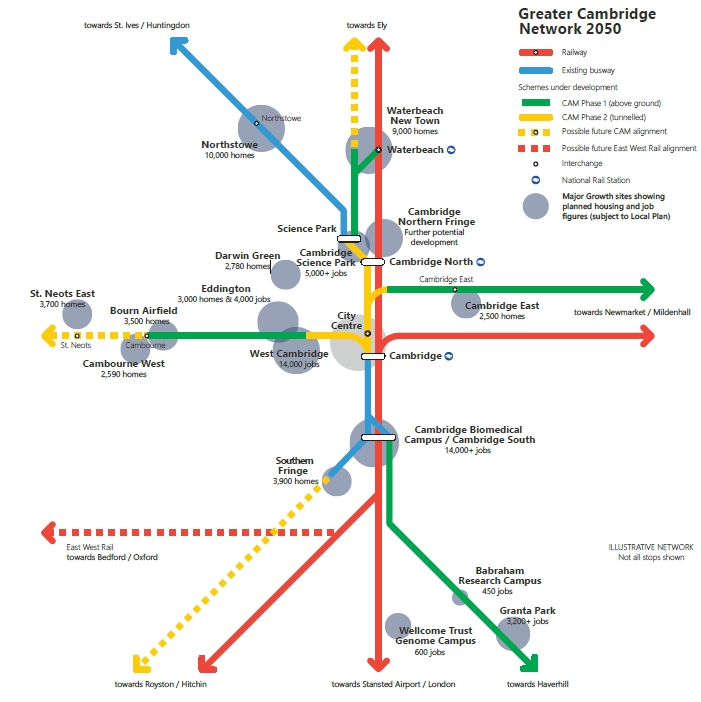
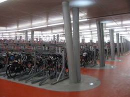
|
Precedent examples of high density bike storage and bike sharing scheme |
|
|
|
High density cycle parking Amsterdam Station, Netherlands (Image source: Image reproduced under Creative Commons License) |
|
|
Bike sharing scheme Madison Avenue, NYC (Image source: Image reproduced under Creative Commons License) |
Innovative approaches to Movement
7.23 NEC will be developed over a long period, and the transport technologies available in that time will also evolve. It will be important that NEC is capable of responding to those changes.
Issue: Innovative approaches to Movement
(13) Question 32: How do we design and plan for a place that makes the best use of current technologies and is also future proofed to respond to changing technologies over time?
|
|
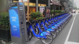
Project Information: The Waterbeach Greenway The Waterbeach Greenway would enable cyclists, walkers and equestrians to travel sustainably from Waterbeach into Cambridge. The Greater Cambridge Partnership consulted on the scheme in November 2018 www.greatercambridge.org.uk/transport/transport-projects/greenways/waterbeach-greenway/ |
Movement within North East Cambridge - Last Mile Trips
7.24 In the Place Making Chapter of this Report, we considered what kind of place this area should be, and what it should be used for. Mixed use development, with a diverse range of residential, employment, education, retail and local amenities would provide the opportunity for those living and working in the area to access many services without using a car.
7.25 Movement networks in the area will need to be designed around people rather than cars. Comprehensive high quality pedestrian and cycle networks should permeate the area and link to the surrounding area.
7.26 Effective 'last mile' links from the station and from the busway stops to destinations like the Science Park will be key to the area's success. This potentially could use innovative solutions like autonomous vehicles, demand responsive transport, or cycle hire schemes.
Issue: Linking the Station to the Science Park
(15) Question 33: what sort of innovative measures could be used to improve links between the Cambridge North Station and destinations like the Science Park?
|
Supporting Study |
Description |
Status |
|
Completed in 2014, provides an overview of sector strengths and likely sources of demand for employment space in the Cambridge Northern Fringe East AAP area. |
Completed |
|
|
Completed in 2014, considered the employment development opportunities of the Cambridge Northern Fringe area. |
Completed |
|
|
Commissioned by the Cambridgeshire and Peterborough
Combined Authority and Cambridge Ahead. To inform the
development of the Local Industrial Strategy and
associated investments. |
Completed |
|
|
Employment Land Review |
Studies which review the demand and supply of employment land. A new study has been commissioned to inform the Local Plan Review, and will also consider North East Cambridge. |
To be completed |