Land North of Cherry Hinton SPD
3. The Site and Surrounding Area
Surrounding areas and adjacent uses
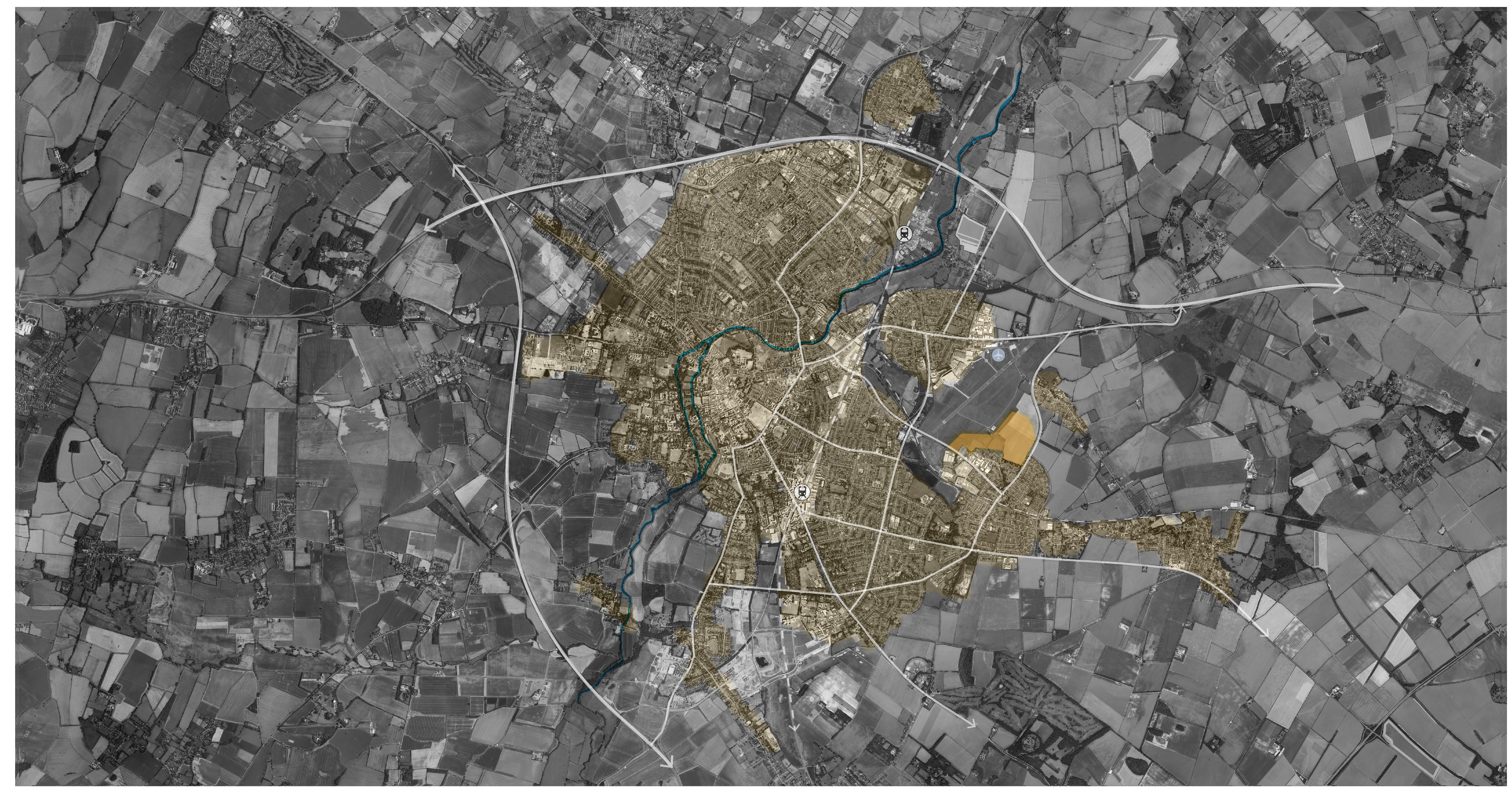
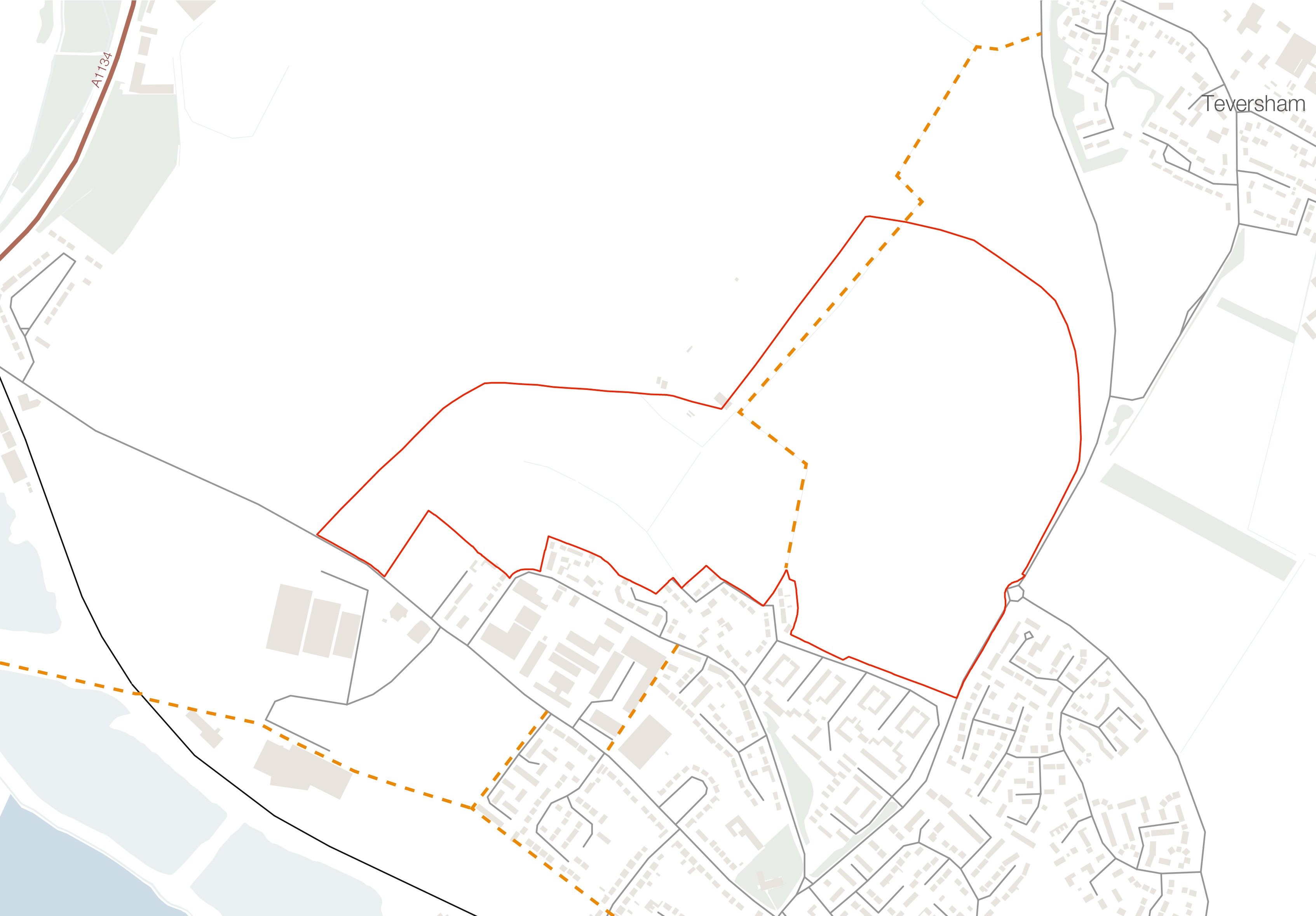
(1) The site is located on the eastern fringe of Cambridge (see figure 6), to the north of Cherry Hinton and adjacent to both residential and non-residential uses, bordering dwellings along Teversham Drift, March Lane and Church End to the south, Cambridge Airport and associated land to the west and north, and Cherry Hinton Road / Airport Way to the east, with agricultural land and the village of Teversham just beyond. The remaining area to the north of the site is in agricultural use.
Allocated site R41 is located immediately adjacent to the site, along Coldham's Lane. Planning consent at this site was obtained in February 2017 for:
'Reserved matters application pursuant to outline approval 14/0028/OUT, as varied by application 16/0970/S73, for the erection of 57 dwellings including 10 No. 1-bed and 19 No. 2-bed apartments together with 20 No. 3-bed and 8 No. 4-bedroom dwellings, open space, car parking and circulation space.'
Transport and movement
(2) The site is adjacent to two major roads connecting it to Cherry Hinton and nearby villages, as well as to the centre of Cambridge.
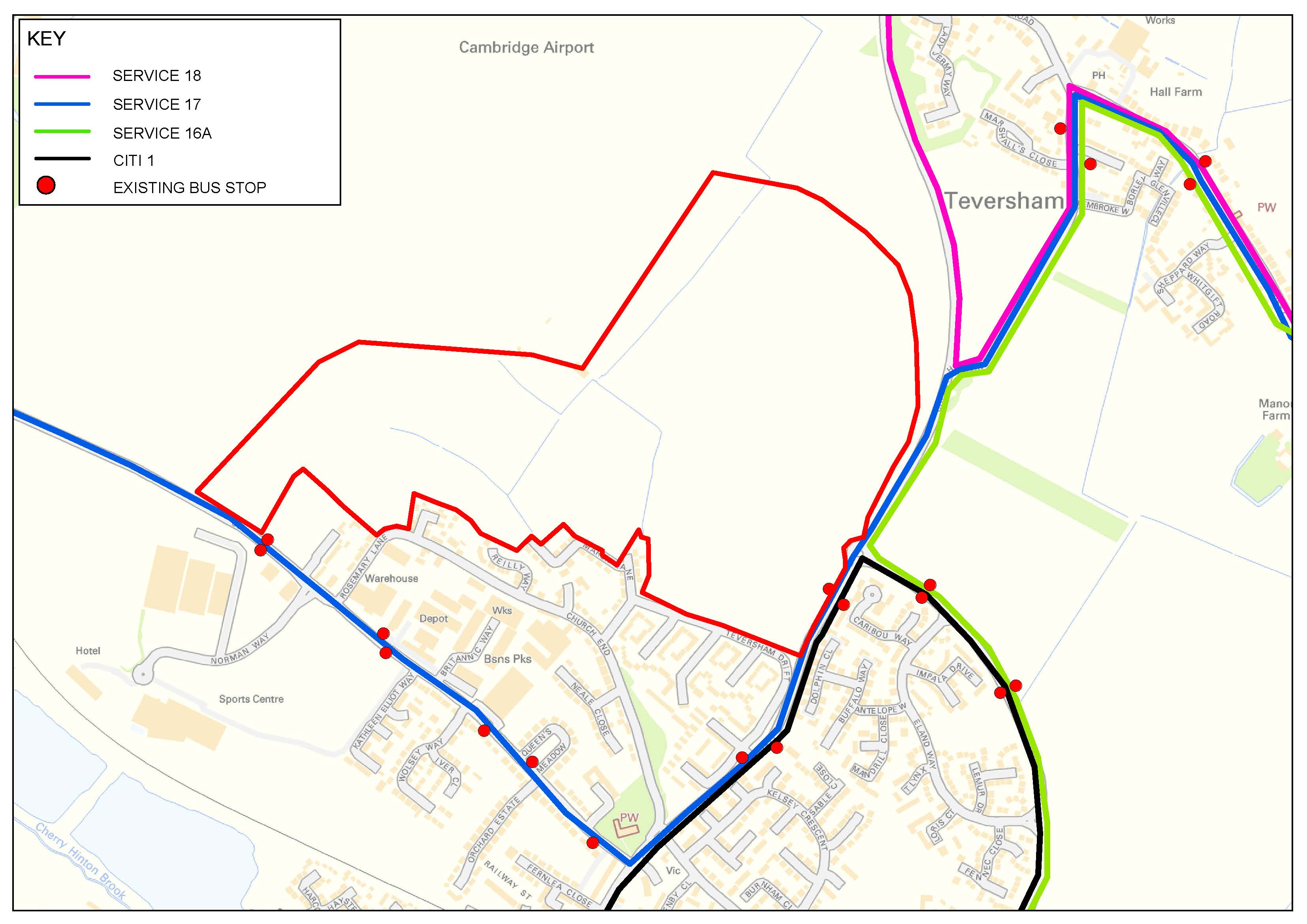
(6) There are a number of bus stops within close proximity of the site, as shown in figure 7. Bus stops along Coldham's Lane are served twice daily by the in and outbound no. 17, service which connects Newmarket, Fulbourn and Teversham with Cambridge at the start and end of the working day. The Citi 1 service from the Cherry Hinton Road bus stops provides frequent services (every 10 minutes) connecting Cambridge to Addenbrookes, Cherry Hinton and Fulbourn.
(1) LNCH is approximately 2.5km from Cambridge Rail Station, which provides regular services to London within approximately 1 hour, and to other nearby settlements. Further, the site is in easy reach of the new Cambridge North rail station, approximately 5.6km to the north west.
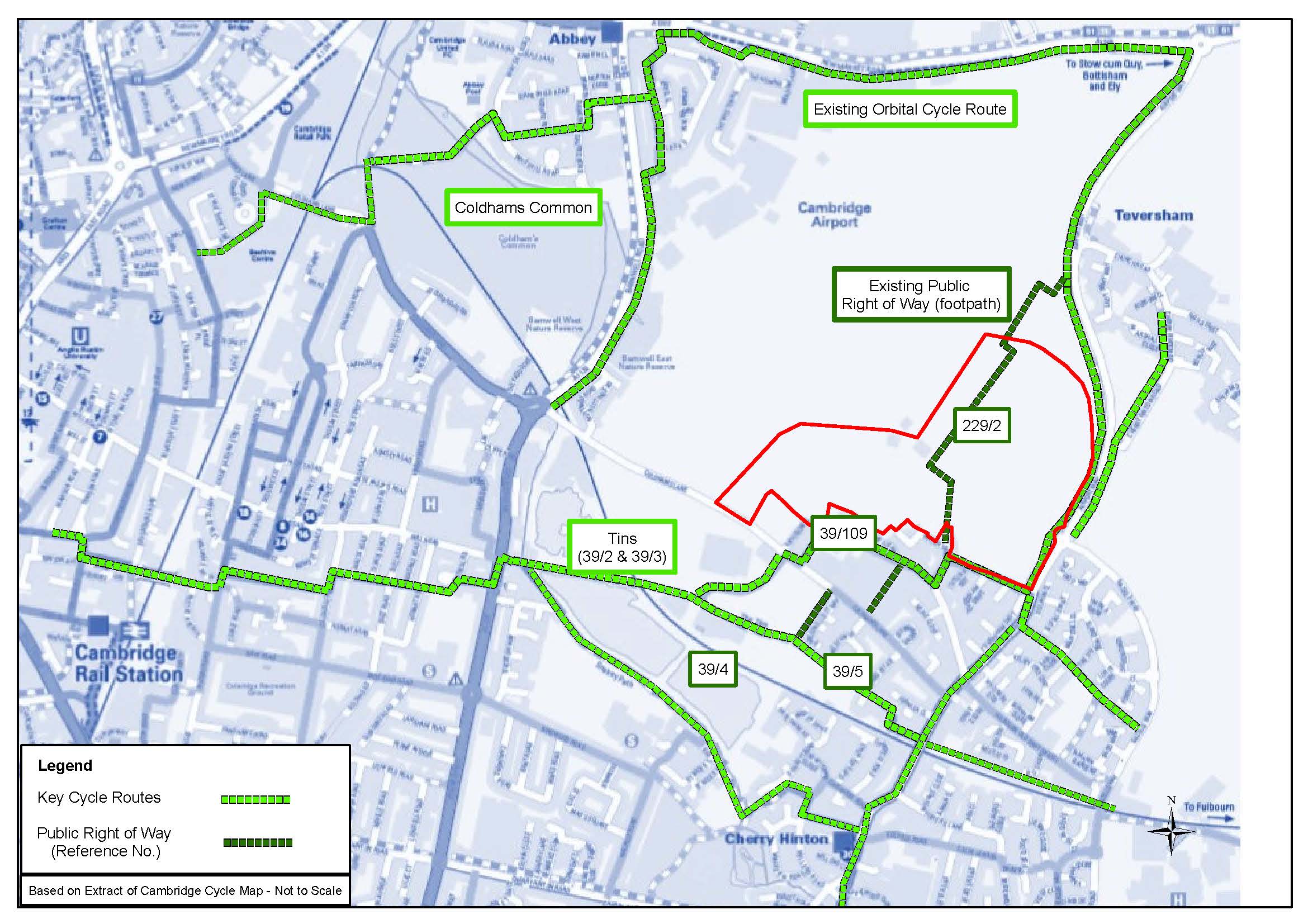
As shown in figure 8, a public right of way (PRoW) runs north-south through the site, linking Cherry Hinton to Teversham. The footpath is accessed from March Lane, leading through to the north-west corner of the site.
(2) Traffic free cycle routes run along the Tins cycle route and adjacent to the site, via Airport Way. A number of other on- and off-road cycle-ways run through Cherry Hinton and into Cambridge.
Services and facilities in Cambridge
The site is located approximately 5km east of Cambridge city centre, which has a good provision of services and facilities, including convenience and comparison retail stores and restaurants (see figure 9).
There are a number of primary and secondary schools and higher and further education establishments across Cambridge, including the University of Cambridge and Anglia Ruskin University.
(1) The city also benefits from a number of employment, research and business centres, including the Cambridge Science Park.
(1) Cambridge city centre offers a good public transport network, including a number of bus services and Cambridge and Cambridge North railway stations, providing direct links to London.
Local facilities
(1) LNCH is located approximately 1 km north of Cherry Hinton village centre. The majority of facilities available within Cherry Hinton can be reached by foot, bike or by public transport within a reasonable time frame.
(2) There are a number of state funded primary and secondary schools in the area, covering the villages of Cherry Hinton and Teversham. The new primary school at the Land North of Newmarket Road will also be within a reasonable walking distance.
(4) There are a number of convenience and comparison retail stores within the local area, including local facilities at Cherry Hinton, which also include a number of restaurants, a bakery and a pharmacy.
(6) The site is located within easy reach of the Cherry Hinton Doctor's Surgery, Brookfields Health Centre and Fulbourn Hospital. In addition, Addenbrooke's Hospital is located approximately 4km south west of the site.
(3) Existing bus stops are located on Cherry Hinton Road and Coldham's Lane, which provide connection to Cherry Hinton and the surrounding areas. Cambridge station is located approximately 2.5km from the site. The Babraham Road Park and Ride is located approximately 4.3 km south of the site.
Green infrastructure
(1) The site lies within a transitional landscape, situated between urban areas of Cambridge city and Cambridge Airport, and the wider rural landscape of South Cambridgeshire. In general, the landscape of the wider area is characterised by relatively low lying land, comprising a variety of land uses, including arable and pastoral fields, roads and settlements.
(1) The immediate surroundings of the site are characterised by a relatively flat agricultural landscape, with field boundary hedgerows and a number of trees within them. The site itself is relatively void of vegetation (see figure 15).
(1) The hedgerow and buffer tree planted strip between the residential development directly to the south of the site is a City Wildlife Site. Hedges either side of Airport Way are County Wildlife Sites. In addition, the road verge along Airport Way has Protected Road Verge status.
(1)
Appropriate sustainable
drainage features should be incorporated into the landscape
framework to mitigate potential surface water flooding. Such
features have the added benefit of enhancing biodiversity and
recreational amenity. Development generated surface water
discharge rates should not exceed existing greenfield
discharge rates from the site with onsite attenuation
provided to mitigate risk to the wider catchment.
Open spaces & recreation
(2) There are a number of public open spaces within close proximity of the site (see figure 16), including the following:
- Church End Green (approximately 0.3km from LNCH)
- Cherry Hinton recreation ground and park (approximately
1.2km from LNCH)
- Cherry Hinton Hall and Park (approximately 2km from LNCH)
- The Plains playing field to be provided as part of the Wing development (approximately 2.8km from LNCH)
- Coldham's Common (approximately 3km from LNCH)
- Cambridge parks including Parker's Piece, Jesus Green, and Midsummer Common (all within 5km of LNCH)
- Wandlebury Country Park (approximately 5.9km from LNCH)
Ecology
(1) Ecological surveys have been undertaken within the site. These include an extended Phase 1 habitat survey (see figure 17) and survey work for protected species (water vole and bats) and birds.
(1) The site supports arable fields, and semi-improved and improved grassland. A combination of hedgerows, ditches and trees are present on field and site boundaries. The semi-improved and improved grassland, and the field margin habitats are assessed to be of low ecological value. The hedgerows within the site, a Habitat of Principal Importance, are of ecological value. Water vole, a Species of Principal Importance, is present within the drainage ditches.
(2) Three non-statutory designated sites are present on the site boundaries:
- Airport Way RSV County Wildlife Site (CWS) is located along the eastern site boundary. The CWS includes the road verges and associated hedgerows/scrub on Airport Way. It is of interest for its population of perennial flax, a nationally scarce plant.
- Teversham Drift Hedgerow City Wildlife Site (CiWS) forms part of the south site boundary.
- Teversham Protected Road Verge (PRV) forms part of the east site boundary. The PRV includes the road verges and associated hedgerows/scrub on Airport way and Cherry Hinton Road. It is of interest for the quality of the grassland habitat present in the road verge.
Local statutory and non-statutory designations
There are no statutory or local landscape designations that cover the site, as shown in figure 18.
(1) There are a number of listed buildings to the south of the site, within Cherry Hinton, including The Red Lion pub (grade II listed), Cherry Hinton Hall (grade II listed) and the grade I listed St Andrew's Church. Teversham village to the north of the site, also contains a number of listed buildings including the grade II* listed Church of All Saints. In addition, the Marshall Airport Control and Office Building located north of the site is grade II listed.
(2) There are no conservation areas immediately adjacent to the site.
(2) The moated site at Manor Farm located some 650m east of the site is a scheduled Ancient monument. The settlement by Caudle Corner Farm, approximately 1.6km south east of the site is also a designated scheduled monument.
The site falls within an area where archaeological assets have previously been identified. Preliminary archeaological investigations have taken place; reporting of the findings will determine whether areas of detailed excavation are required.
(2) Teversham Drift City Wildlife Site lies between the site and existing settlement.
In addition to the above, there are also a number of non-designated heritage assets within proximity of the site which contribute to the character of the area.
(1) The site has historically been used for agricultural purposes. The maps below show the growth of the area immediately surrounding the site and illustrate the growth of Cherry Hinton from a small village parish in the late 1800s to its current compact suburban form. The footpath extending through from March Lane to the existing ditch on the site should be retained, together with the historic hedgerow which is still present on the site.
The historic core of Cherry Hinton is organised along the high street, with later phases of development extending out from this core. Thus the built form in the locality originates from different periods and features different styles and scales. There is no single morphology that is characteristic of the area.
Neighbourhood context analysis
A study of the existing features and trends apparent within Cherry Hinton will help inform the emerging development principles and design concepts for LNCH.
(1) The following pages detail the key characteristics of Cherry Hinton, followed by a short summary and conclusion of the key findings used to inform the development principles set out in section 5.
Cherry Hinton characteristics
Cherry Hinton village is located immediately south of the site and 4 miles east of Cambridge city centre.
The residential areas of Cherry Hinton largely comprise a mix of 2-3 storey semi-detached, terraced and detached dwellings with pitched roofs. 'Traditional' streets with detached housing and rear gardens are the most common typology, although in the immediate vicinity of the site (Teversham Drift) housing is arranged around internal courtyards.
The historic morphology shows clear plot layouts with buildings fronting main streets; the later additions of the 60s and 70s along Teversham Drift are 'Radburn' type layouts, characterised by back gardens facing the streets, and the fronts of houses facing each other across communal gardens.
The village centre comprises a linear high street running north - south through the village. The southern end of the high street is characterised by a triangular form.
The village comprises a mix of uses including The Red Lion pub, St Andrew's Church, village hall and sports centre, and a range of shops.
(1) Cherry Hinton has a good range of open spaces, including Cherry Hinton Hall and Park, the recreation grounds, allotment provision and a range of natural and semi-natural green spaces. The quality of natural and semi-natural green spaces varies, with evidence of a lack of maintenance.
Analysis of Cherry Hinton identified the following key features:
- Mix of semi-detached, terraced and detached dwellings
- Predominately red brick buildings with some render and textured brick on traditional properties and cladding on contemporary dwellings
- Chimneys on dwellings along 'traditional' streets
- Mix of boundary treatments, predominately brick walls along traditional streets and low level fencing or hedgerows fronting more contemporary dwellings
- Mature cherry trees are characteristic of the village
- Triangular form to southern end of village centre.
Neighbourhood analysis - summary of key findings
(1) Findings from the analysis should be taken into consideration in the development of design proposals for the site.
(1) Key findings from the analysis are detailed below. The key precedents to apply to LNCH to ensure a high-quality development that is reflective of the local area include the following:
- Triangular openings to key spaces
- Mix of materials, predominately brick with cladding details
- Chimneys on dwellings to add interest to roofscape. Chimneys should form a functional role in the design
- Predominately linear street patterns
- Mix of low level hedging and brick wall boundary treatments.
- Varied densities with lower densities adjoining the Site
- Mixed use located along village centre approach
- Varied building heights and plot widths but 2/3 storey residential buildings predominate
- Detached housing and 'traditional' streets most common
- Large front gardens to many residential dwellings
- Internal courtyards
- Street widening to create triangular forms
- Historic buildings in core areas create attractive vistas and play an important role in the public realm
Vernacular
- Mix of architectural styles; contemporary architecture can be found toward the edge of Cherry Hinton
- Traditional housing typically characterised by brick wall boundaries; contemporary dwellings with low level hedgerow / small front lawn boundary treatment
- Chimneys on traditional housing; no chimneys on contemporary dwellings
Residential street pattern
- Linear street pattern with some curved residential roads
- Some streets characterised by Radburn-style layouts
- Core of village is defined by a connected street pattern centred on the linear high street
- Cherry trees are a common feature of Cherry Hinton
- Limited public open space in vicinity of the site
The site
The following pages set out the site's constraints and opportunities.
Edges
Southern edge - residential use
The southern edge of the site is predominately characterised by residential streets and dwellings.
The southern edge includes the Teversham Drift City Wildlife Site. This narrow wooded buffer strip screens the edge of the developed village from the green belt / wider area and will continue to play a role in buffering the existing developments from the new. The buffer strip will remain a City Wildlife Site and should be protected and enhanced.


Western edge - Cambridge Airport and Green Belt
Cambridge Airport land borders the site to the west. The airport land is characterised by regularly mown grass and open views across to the airport and city beyond.
(2) The openness of the Green Belt land should be retained in order to prevent coalescence with Teversham.
Eastern edge - Cherry Hinton Road / Airport Way
(1) The east of the site is contained by Cherry Hinton Road and Airport Way, connecting the Site to Cherry Hinton, Teversham, Cambridge and the A14.
(1) Visual and noise screening should be incorporated along this edge as well as opportunities for enhancing wildlife.
The area immediately north of the site is within a green belt corridor. As noted on page 11, the green belt purposes seek to preserve the character of Cambridge, maintain and enhance the quality of this setting, and prevent coalescence of communities. Proposals should ensure no impact on the openness of Green Belt land to the north of the site, which has been retained to prevent coalescence with Teversham.
The area immediately west of the site has been identified as having long term potential for further housing development outside of the draft Local Plan time frame and in accordance with the spatial strategy set out in the Cambridge East AAP.
(2) The site is in a generally low lying area, which is typical of this part of Cambridge and Cherry Hinton. The site is located some 2km north of the Magog Hills, which lie just south of Cherry Hinton. There are some changes in levels across the site. Within the south eastern portion of the site, there is a distinct ridge which falls away in all directions. At its highest point, the ridge is approximately 5 metres above the general site levels.
(2) The site falls within Flood Zone 1, and is therefore at low risk from fluvial flooding. The site is at risk from surface water flooding, instances of surface water flooding are known to have occurred in the area immediately adjacent the existing drainage ditches within the site.
There is a lack of existing vegetation within the site.
(1) Due to the location of the site adjacent to the International Airport, any future landscaping scheme should ensure bird populations that pose a threat to the airfield are discouraged; other farmland birds should be encouraged as mitigation for loss of farmland.
A public footpath (Cambridgeshire County Council path no. 109) runs north-south through the site, providing a footpath link from Cherry Hinton to Teversham. This footpath link should be retained.
(1) There is currently no vehicular access to the site, given it is in use for agricultural purposes and, in part, airport land. Agricultural vehicles access the site via Airport Way. Gated entrances exist via Rosemary Lane and March Lane into the airport land. Pedestrian access to the land is limited to the public footpath, which crosses the site.
(1) An Intermediate Pressure Gas Main currently runs through the southern half of the site. There is potential to re-route the gas main and associated restrictions on building around it to ensure the route of the pipe is compatible with the development principles of the site, as part of an integrated design solution.
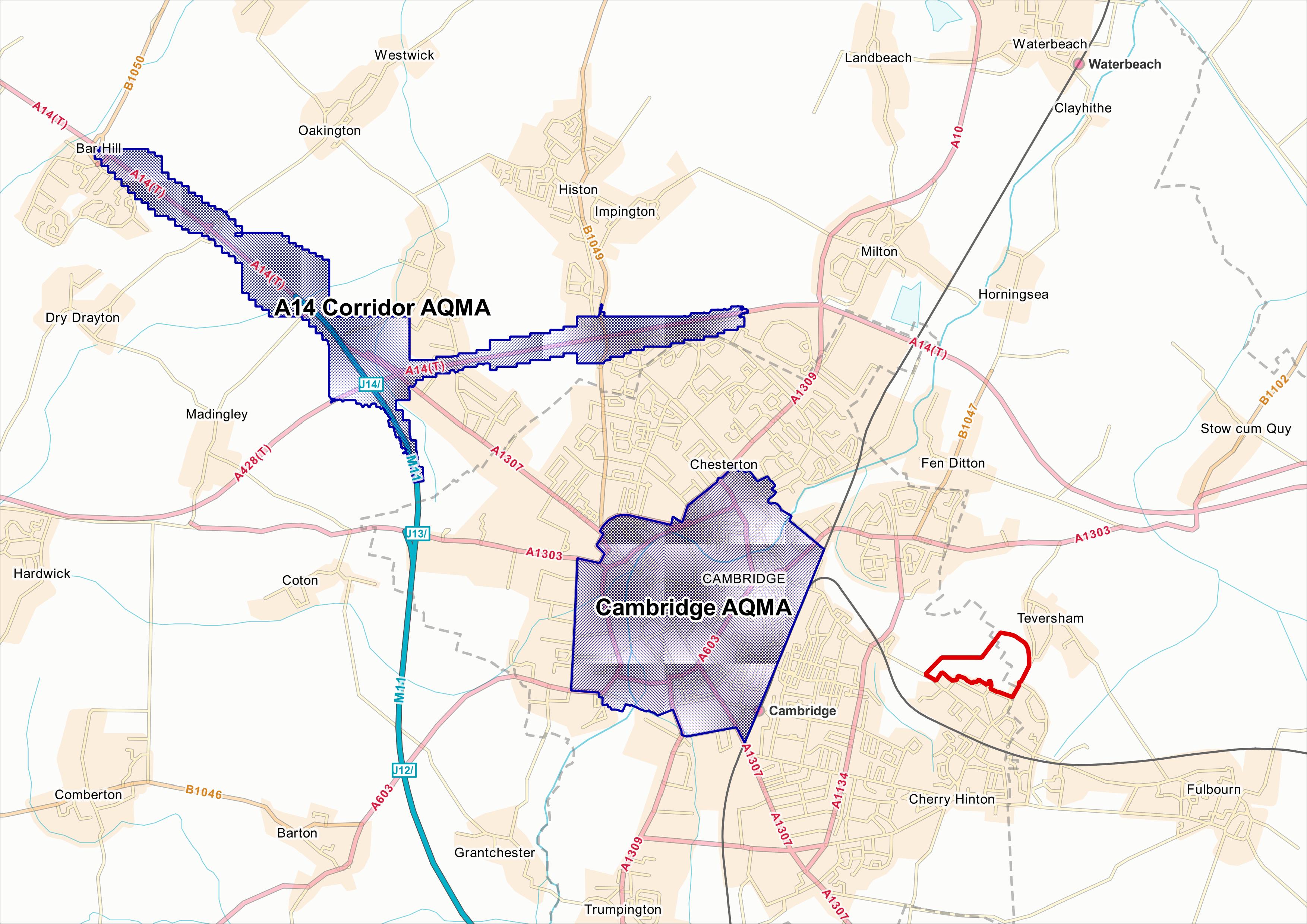
(1) Both local authorities have declared Air Quality Management Areas (AQMAs) for exceedances of air quality objectives. See figure 35.
Air quality conditions at the site will be affected by a range of local emission sources, including those from local road traffic. Activities at Cambridge Airport will give rise to emissions of air pollutants, and possibly odour, which could have an effect on air quality across the site.
(1) The construction and operation of the proposed development has the potential to affect local air quality at existing residential properties, including those within the AQMAs. Key considerations for air quality include the following:
- Presence of AQMA's
- Potential impact on air quality within the AQMA
- Need to mitigate so the development does not have an adverse impact upon air quality within the AQMA's.
- Mitigation at the construction phase to minimise impact on the local air quality for existing residential properties
- Mitigation at the operational phases of the development to minimise impact on the local air quality not only on existing residential properties but also proposed residential properties
- Appropriate mitigation measures should be incorporated in the development proposals to avoid or lessen potential impacts.
 Ground conditions
Preliminary ground investigation works undertaken to date on-site have identified some potential localised soil contamination which is associated with current and historical land uses. As it stands, the principle of the development take into account these potential areas of contamination and, where possible, locates more sensitive land uses away from them accordingly.
Further detailed ground investigation works will be undertaken to better define the exact extent of any contamination on-site and provide remediation techniques and mitigation measures where necessary to facilitate the development.
(1) It is accepted that the site is adjacent to an airport and that noise is a key consideration. The allocated area is affected by both airport and other external noise (i.e. road traffic).
Under the process of Environmental Impact Assessment (EIA), the applicants' will be required to prepare a Noise Assessment submitted as part of the outline planning application. This should consider existing noise levels at and around the site from a range of sources (e.g. road and rail) and also specific activities at Cambridge Airport (e.g. take offs and landings, taxiing aircraft, and aircraft engine testing). It will be necessary in each case to make a prediction of noise impact upon the proposed development area, and where necessary to identify mitigation to achieve satisfactory levels of noise, both internally and for relevant amenity areas.
Mitigation may include consideration of the development layout, building orientation and building heights, positioning of sensitive land uses or open spaces, as well as the design and acoustic insulation of properties (where appropriate).
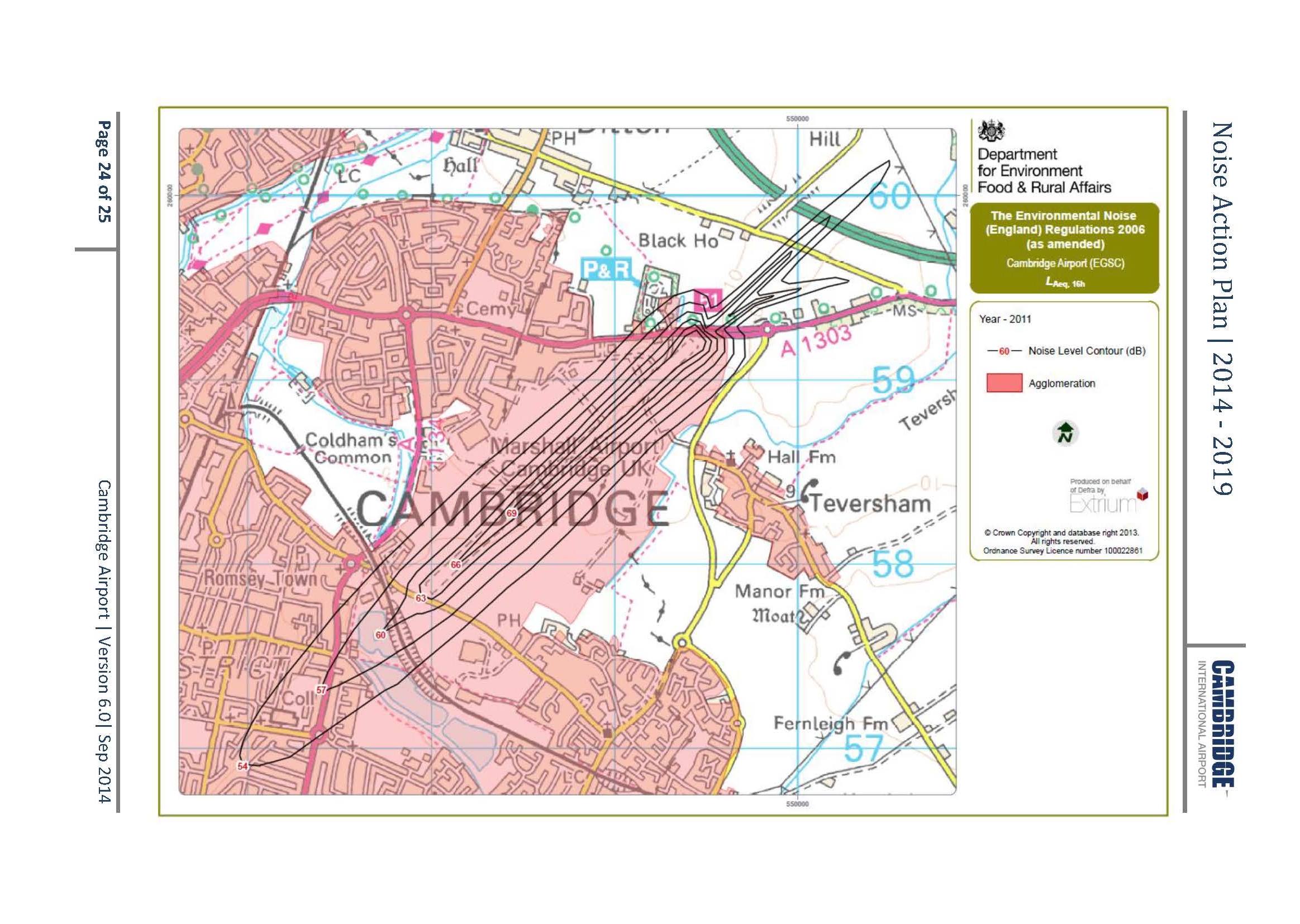
In taking the decision to allocate the site for development, the Council took into account noise evidence prepared by an expert noise consultant, which demonstrates on a preliminary basis that noise effects are expected to be within acceptable ranges and can be dealt with through normal design measures (see figure 36). The EIA process and detailed noise assessment will need to develop this further in support of a planning application, to the satisfaction of the Local Planning Authority.
Airport safety
The airport radar is a key tool to allow Air Traffic Control to safely manage the airspace near to the airport. The current location of the airport radar, and its associated safeguarding criteria, imposes height restrictions across the site to ensure the radar remains fully effective and to maintain aircraft safety. The radar in its current position would limit building heights and compromise the capacity of the site to deliver housing and other uses. The radar will need to be relocated to allow the development to proceed.
The airport fire crews must be fully drilled and ready to respond to a potential incident on the airfield. Training is currently delivered on site, using the airport's Fire Training Ground located adjacent to the western boundary of the site. It is recognised that fire training in close proximity to new development may cause concerns for new residents. Marshall has committed to ceasing activity at the current fire training ground to allow the development to proceed. It is anticipated that a S106 agreement will place a positive obligation on Marshall to cease use of the fire training ground before first occupation of homes, thus protecting the amenity of future residents. Preliminary enquiries suggest that it would be viable to undertake training of the Airport Fire Crew at alternative third party airport locations. At the current time, there are no proposals to relocate the facility within the Airport site.
The airport uses a range of other airport navigational aids to safely manage aircraft arrivals and departures. The potential impacts of the development on all airport infrastructure will need to be assessed on an ongoing basis to influence the design, and to ensure navigational aids are appropriately calibrated as development comes forward.
(1) As the site is located adjacent to Cambridge Airport, there are other constraints that apply. These are not ultimate constraints to the development, but will have an impact on the form of the development and the design of open space. Industry guidance and best practice on matters such as lighting, landscaping, drainage and construction management will be applied to ensure structures are not built in locations that create safety risks, and to ensure design solutions and maintenance regimes are put in place to proactively manage potential risks to aircraft. These constraints are set out in Safeguarding of Aerodromes Advice Notes, published by the Airport Operators Association, as follows:
- AN02 Lighting
- AN03 Potential Bird Hazards from Amenity Landscaping and Building Design
- AN06 Potential Bird Hazards from Sustainable Urban Drainage Schemes
- AN08 Potential Bird Hazards from Building Design.
In addition, the following airport constraints have been considered:
- Obstacle Limitation Surfaces - height restrictions associated with the airport's runways
- Public Safety Zones - areas that are protected from development in the interests of public safety, which are located at the runway ends and thus are not impacted by the proposed development
- Navigation Equipment - the continued safe operation of the airport's navigational equipment in accordance with CAA Guidance Note CAP670: Air Traffic Services Safety Requirements
- Instrumental Landing System (Localiser)
- VHF Direction Finder
- Distance Measuring Equipment.
(2) Whilst not an exhaustive list, the following constraints should be taken into account when developing design proposals for LNCH:
- Green belt boundary
- Retention of public footpath
- Protected grass verge along Airport Way
- City Wildlife Site along Teversham Drift (hedgerow)
- Retention of existing vegetation where appropriate
- Surface water flooding and the incorporation of a Sustainable Urban Drainage System
- Gas pipe and easement
- Response to noise from the Airport / GRE and traffic along Airport Way / Cherry Hinton Road
- Protection of the amenity of residential dwellings immediately bordering the site
- Limited height under Coldham's Lane Bridge.
